
12:00 PM | ***Accumulating snow in the DC-to-Philly-to-NYC corridor from late this evening into early tomorrow morning***
Paul Dorian

A key factor during the upcoming snow event in the Mid-Atlantic region will be a strong and still-strengthening upper-level jet streak that will enhance upward motion at the surface and help to produce several inches of accumulating snow in many spots. Map courtesy NOAA, tropicaltidbits.com
Overview
A cold front that passed through the region last night has set up shop in the southern Mid-Atlantic region and low pressure will slide along the frontal boundary zone resulting in accumulating snow all along the DC-to-Philly-to-NYC corridor from later this evening into early Saturday. While there will be limited moisture available to this system, and it’ll be a fast-mover, a strong and still-strengthening upper-level jet streak will enhance upward motion in the DC-to-Philly-to-NYC corridor and the result will be several inches of snow in many spots by Saturday morning. Contrary to the storm earlier this week, this upcoming system will encounter an established cold, dry air mass on its front side meaning snow will be the dominate precipitation type all the way down to the DC metro region.

Low pressure will be approaching the Mid-Atlantic coastline by the wee hours of the morning with accumulating snow falling in the DC-to-Philly-to-NYC corridor. Map courtesy NOAA, tropicaltidbits.com
Details
A cold front has stalled out across the southern Mid-Atlantic region and the next low pressure system will push along the frontal boundary zone later today and tonight. As a result of the influx of reinforcing cold, dry air, the arrival of moisture on Friday evening is going to result in snow being the dominant precipitation type…all the way down to the DC metro region.

The circled area on this forecast map for later tonight highlights the region with strong upward motion produced by a powerful upper-level jet streak. Map courtesy NOAA, Pivotal Weather
While there are limiting factors for snow accumulations with this approaching low pressure system, there are also a couple of important favorable factors. On the limiting side, this approaching low pressure system will be rather weak, a fast-mover (about an 8 hour period of snow expected), and it’ll have limited amounts of available moisture. However, I believe several inches of snow is still a possibility in much of the I-95 corridor as a result of a couple of favorable factors.

Colder-than-normal air will follow the early weekend snow event in the Mid-Atlantic region with below-normal temperatures on Saturday night and Sunday. Map courtesy NOAA, tropicaltidbits.com
First, there will be a strong and still-strengthening jet streak in the upper part of the atmosphere that will generate strong upward motion at the surface adding to the chance for significant accumulating snow. By the way, given the strength of the upward motion due to the powerful jet streak aloft, there is the chance for some “thundersnow” during this event somewhere in the Mid-Atlantic region. Second, the fresh cold and dry air mass in the wake of last night’s cold frontal passage is creating atmospheric conditions that will allow for a high “snow-to-rain” ratios (i.e., greater than the normal 10:1…probably on the order of 12 or 13-to-1) and this suggests even a small amount of “liquid equivalent” precipitation can produce several inches of snow which would be on the light and fluffy side…not like the heavy, wet snow of earlier in the week.
Snowfall estimates have been tweaked up a bit and are as follows: 3-6 inches in both the DC and Philly metro regions from later this evening into early Saturday morning with isolated higher amounts possible…2-5 inches across the NYC metro area with isolated higher amounts possible. This will be a quick-moving system with about an 8 hour period of snow (light and fluffy texture) from later this evening into tomorrow morning (10-11 PM to 8-9 AM).
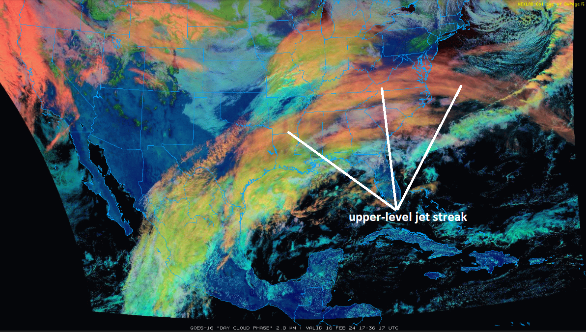
A mid-day (Friday) look on a satellite image of high clouds associated with a key player for the upcoming snow event in the Mid-Atlantic region - i.e., a strong and still intensifying upper-level jet streak - which extends all the way from eastern Texas to the east coast. Image courtesy NOAA GOES-16 (Day Cloud Phase).
Following the departure of the low, cold, breezy and dry conditions will dominate for the remainder of the weekend as high pressure pushes in from the west and the departing low pressure intensifies off to our east. This high pressure then pushes to our east early next week which will begin a warming trend as a low-level southwesterly flow of air should develop in the Mid-Atlantic region.
Meteorologist Paul Dorian
Arcfield
arcfieldweather.com