****Another cold shot pushes into the Mid-Atlantic region with overnight lows in the 20's…heavy rain/strong wind event late Friday night/Saturday in Mid-Atlantic...significant snow farther north****
Paul Dorian

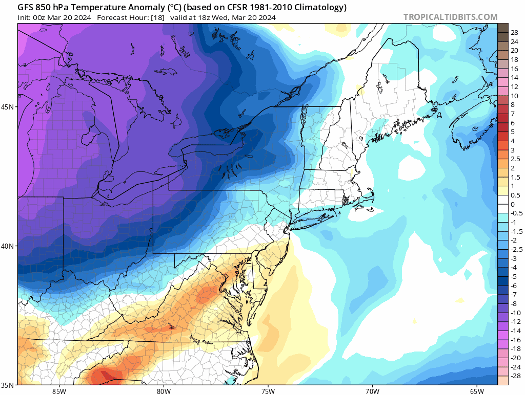
The passage of a strong cold front late Wednesday will usher in a colder-than-normal air mass for Thursday and Friday and overnight temperatures should fall well below the freezing mark in many spots. Maps courtesy NOAA, tropicaltidbits.com
Overview
An outbreak of colder-than-normal air in the Mid-Atlantic region earlier this week will be followed up by a second shot that arrives on Wednesday night following the passage of a strong cold frontal system. The approaching strong cold front will produce some rain shower activity in the southern Mid-Atlantic region and it is likely to be just cold enough for snow showers and perhaps even heavier snow squalls across upstate Pennsylvania and interior New York State. Following the passage of the front, temperatures will drop into the 20’s late Wednesday night and again late Thursday night…even in the immediate I-95 corridor region.
The cold air mass sticks around into the day on Friday and then attention will turn to a developing low pressure system that is likely to intensify as it pushes to a position just off the Mid-Atlantic coastline by early Saturday morning. As a result, a heavy rain event is likely from late Friday night into Saturday from the I-95 corridor region to the coast. In fact, there is the possibility for as much as 2-4 inches of rain during the early part of the weekend in the DC-to-Philly-to-NYC corridor…watch out for localized flooding. Farther north, the early weekend storm system can bring substantial snowfall of a foot or more to ski country including upstate New York and much of northern New England. On the back side of the storm, winds can become very strong out of the N-NW with gusts possible up to the 40-50 mph range from late Saturday into Sunday and chilly air will push into the northeastern part of the nation.
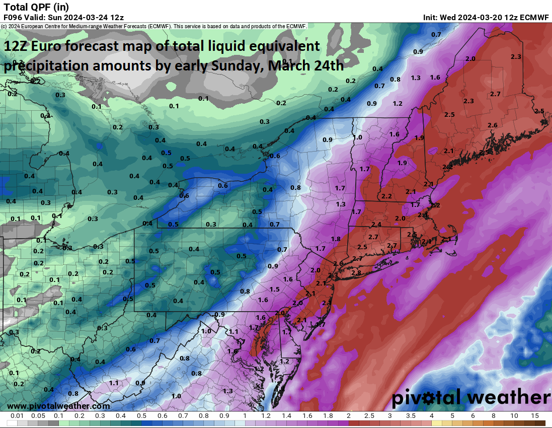
Forecast map of total liquid equivalent precipitation amounts between now and early Sunday, March 24th, as depicted by the 12Z Euro. The rainfall can be significant from the I-95 corridor to the coast with 2-3 inches on the table…watch for localized flooding. Map courtesy ECMWF, Pivotal Weather
Details
Despite the fact that spring has officially sprung, there will be additional cold air outbreaks across the northern US during the next couple of weeks taking us right into the early part of April. One outbreak arrived in the Mid-Atlantic region earlier in the week, and a second and even more impressive shot of cold air arrives on Wednesday night following the late day passage of a strong cold front. It appears quite likely that temperatures will drop to well below the freezing mark in many spots both late Wednesday night and again later Thursday night and this includes in the immediate I-95 corridor region.
The average low temperatures for this date in the big cities are as follows: Philly 35 degrees in Philly, 40 degrees in DC, and 37 degrees in New York City so the anticipated overnight lows in the middle or upper 20’s would be well below-normal for this time of year. Temperatures on Thursday will generally be confined to the 40’s for highs despite plenty of sunshine and there will be a stiff NW breeze making it feel even colder than the actual air temperatures. After another overnight with temperatures bottoming out in the 20’s along the I-95 corridor, it may turn a bit milder on Friday; however, it’ll remain below-normal for this time of year. Skies should start the day on Friday as mostly sunny; however, clouds will be on the increase by the latter stages of the afternoon.

Strong low pressure will push to a position just off the Mid-Atlantic coastline by early Saturday morning likely leading to a soaking and heavy rain event for the I-95 corridor with as much as 2-3 inches on the table for the big city metro regions of DC, Philly and NYC....even some isolated higher amounts Map courtesy NOAA, tropicaltidbits.com
The increase in clouds later Friday will be the result of moisture heading this way from the Gulf of Mexico and there is plenty of it to tap into. Low pressure will push out of the southeastern states by later Friday night and then intensify early Saturday morning as it moves to a position just off the Mid-Atlantic coastline. As a result, rain is likely to spread into the Mid-Atlantic region later Friday night and continue through much of the day on Saturday and the rain will be heavy at times. In fact, as much as 2-4 inches of rain can fall in the DC-to-Philly-to-NYC corridor - isolated higher amounts are even possible - by the time the storm winds down on Saturday evening…watch out for localized flooding.
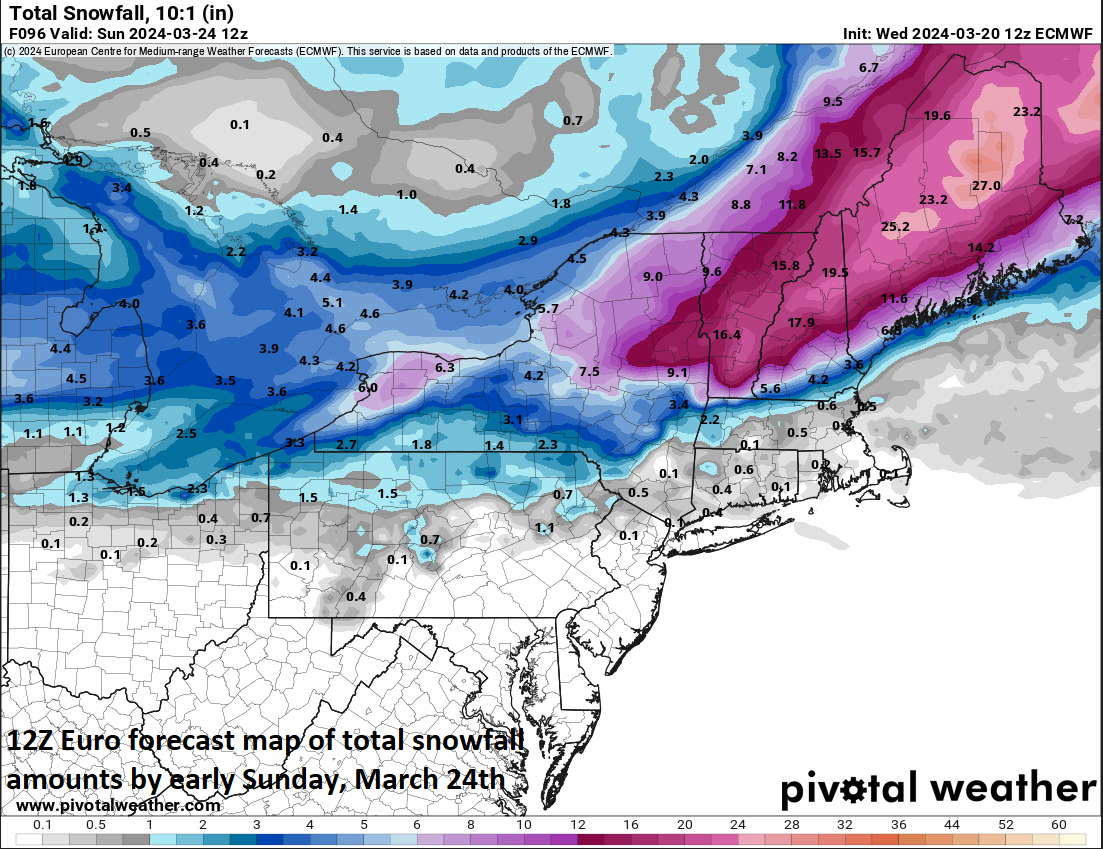
Forecast map of total snowfall amounts between now and early Sunday, March 24th, as depicted by the 12Z Euro and it can be substantial across portions of upstate NY and northern New England. Map courtesy ECMWF, Pivotal Weather
Farther north, there is likely to be enough cold air around on Saturday for substantial accumulating snow of a foot or more in such places as upstate New York and interior northern New England…many of the same places that can get hit later today by snow showers and isolated heavier snow squalls. On the back side of the storm, winds can become very strong out of the N-NW with gusts possible up to the 40-50 mph range from late Saturday into Sunday and chilly air will push into the northeastern part of the nation. Given the expected very wet ground conditions, these powerful winds could bring down some weakened trees…something to be on the alert for from late Saturday into Sunday.
Meteorologist Paul Dorian
Arcfield
arcfieldweather.com
Follow us on Facebook, Twitter, YouTube