
7:00 AM (Wednesday) - **HOT stretch of weather begins early next week...possible strong-to-severe storms late Friday should set stage for a nice weekend**
Paul Dorian

The hottest weather so far this season comes to the Mid-Atlantic region next week with multiple 90+ days on the table. Map courtesy ECMWF, tropicaltidbits.com
Overview
Philly and DC have not seen 90 degrees yet this month, but that is about to change in a big way. It’ll turn very warm on Thursday and Friday and 90 degree highs are certainly on the table, but the real heat comes next week. In fact, there is a chance for an extended period of 90+ degrees beginning next Monday which will follow what should be a pretty decent Father’s Day weekend. The nice weekend weather will be set up by the passage of a cool front on Friday night that can spark some strong-to-severe thunderstorm activity.

Comfortable warmth today gives way to very warm conditions on Thursday and Friday, but the real heat begins early next week for the Mid-Atlantic region. Map courtesy ECMWF, tropicaltidbits.com
Details
Temperatures have not reached 90 degrees so far this month in Philly (PHL) and Washington, D.C. (DCA), but that is likely to change later this week and next week could very well present an extended stretch of hot weather in the Mid-Atlantic region. Today’s temperatures will remain in the comfortable zone, but as an upper-level ridge builds in on Thursday temperature will soar…likely to the upper 80’s in many spots along the I-95 corridor. The hottest day of this week comes on Friday just ahead of an approaching cold front with highs likely at 90 degrees or slightly above in DC, Philly and NYC.
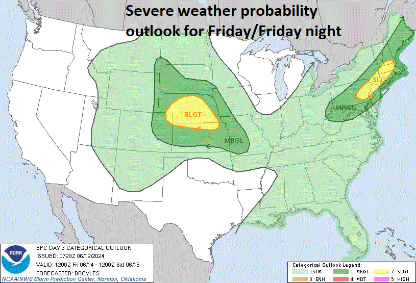
A cool frontal passage late Friday can spark a few strong-to-severe thunderstorms in the Mid-Atlantic region. Map courtesy NOAA/SPC
The arrival of the cool front late Friday will likely produce some strong-to-severe thunderstorm activity late in the day or early at night, but those storms will help to set the stage for a decent Father’s Day weekend. There should be plenty of sunshine on both weekend days and - while it’ll be quite warm - temperatures should stay in the 80’s for afternoon highs. The real heat gets turned on beginning next Monday as strong upper-level ridging builds into the eastern US. Temperatures should climb into the 90’s on Monday, June 17th, in the I-95 corridor and likely stay in the 90’s through at least mid-week and perhaps all the way through next week…get the A/C ready.
Meteorologist Paul Dorian
Arcfield
arcfieldweather.com