
1:15 PM | ***Severe weather threat across much of the interior Northeast US and Mid-Atlantic...new tropical wave off SE US coast to add some "fuel to the fire" later in the week***
Paul Dorian

Thunderstorms are breaking out across the interior Mid-Atlantic and NE US and a rather widespread severe weather event is likely from this afternoon through tonight with tornadoes on the table. Images courtesy NOAA, College of DuPage
Overview
A rather widespread severe weather event is likely across much of the interior Northeast US and Mid-Atlantic region from this afternoon through tonight and tornadoes are certainly on the table. The main area of concern for tornadic activity extends from south-central Pennsylvania to upstate New York and Vermont...areas not usually thought of when it comes to tornado threats. The atmosphere is becoming increasingly unstable this afternoon given the combination of ingredients that includes high heat and humidity, low-level wind shear, and an incoming cold frontal system. The chance of showers and thunderstorms may decrease some on Thursday, but then it should rise again on Thursday night and Friday when moisture from a newly developing tropical wave enters the picture. This system will add some “fuel to the fire” by the end of the work week adding to chance for some heavy downpours on Friday along the eastern seaboard. The high heat of recent days will back off some on Thursday, Friday, and Saturday, but then will return in full force once again for Sunday, Monday, and Tuesday.
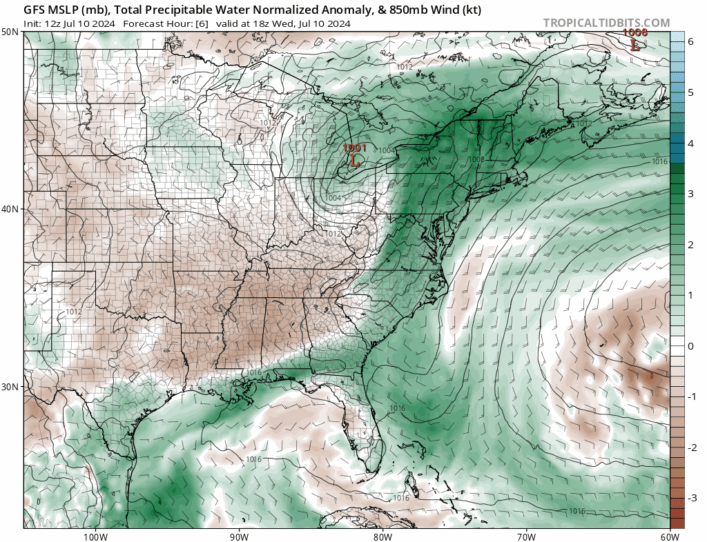
Highly anomalous precipitable water amounts (shown in green) exist today along the east coast and will actually become reinforced on Thursday and Friday by a newly forming tropical system off the SE US coastline. The moist region (shown in green) will actually back to the north and west later this week raising the chance for additional showers and thunderstorms. Maps courtesy NOAA, tropicaltidbits.com
Details
It is not often that the atmosphere becomes this unstable across the interior sections of the Northeast US and Mid-Atlantic, but there is the chance for multiple supercell thunderstorms later today and tornadoes are certainly on the table. The combination of high heat, tropical moisture, low-level wind shear, low-level jet, and an incoming cold front will destabilize the atmosphere markedly during the next few hours and thunderstorms will become more and more numerous. While the remnant low of Beryl has pushed well off to the northwest of here, it is contributing to a southerly flow of air along the eastern seaboard which is bringing tropical air all the way from the southwest Atlantic Ocean to eastern New England. While the greatest instability later today will take place across upstate PA, upstate NY, and Vermont, there can be some strong-to-severe thunderstorm activity that makes its way all the way into the Mid-Atlantic’s I-95 corridor; especially, on the northwest side.

The atmosphere is becoming increasingly unstable this afternoon in the Mid-Atlantic region and Northeast US and severe thunderstorms and tornadoes are a serious threat. One parameter that is used to determine stability in the atmosphere is known as Convection Available Potential Energy (CAPE) and the circled region on the map features high CAPE values which is indicative of very unstable atmospheric conditions. Map courtesy NOAA/WPC
The incoming cold front that is adding to the severe weather threat of today will slide to the east coast during the overnight hours and then hang nearby on Thursday and Friday. The proximity of the front and the fact that a newly developing tropical system can throw some moisture this way raises the chance for additional showers and thunderstorms later in the week. Any shower or thunderstorm that forms in the Thursday night/Friday/Friday night time frame can result in very heavy rainfall. The high heat of recent days is likely to back off some on Thursday, Friday and Saturday, but humidity will remain a factor.

A new tropical wave (circled region) is now developing off the SE US coastline and it looks like it will back to the north and west during the next couple of days and this will enhance chances for heavy rainfall on Thursday night and Friday in some areas near and along the east coast. Map courtesy NOAA/NHC
Looking ahead, the frontal moisture along the east coast should finally push to the western Atlantic Ocean later this weekend and this will reduce the chance for rain around here by Sunday. However, to go along with those likely rain-free conditions, the high heat is likely to return in full force with intensifying upper-level ridging near the east coast. In fact, temperatures can soar once again into the middle and upper 90’s for afternoon highs early next week in places like DC, Philly, and NYC.
Meteorologist Paul Dorian
Arcfield
arcfieldweather.com
Follow us on Facebook, Twitter, YouTube