
10:20 AM (Tues) | **Threat for heavy rainfall increases later tomorrow and lasts into the weekend...a combination of tropical moisture associated with Beryl’s remains and a stalling frontal system**
Paul Dorian

With the remnant low associated with Beryl to the northwest of the I-95 corridor, tropical moisture (indicated by green) will ride up along the eastern seaboard from southwest-to-northeast. The combination of tropical moisture and a stalling-out frontal system will result in an enhanced threat of some very heavy rainfall in the period from later tomorrow to Saturday. Map courtesy tropicaltidbits.com, NOAA
Overview
Rainfall has been rather sporadic in much of the Mid-Atlantic region during the past couple of months with some spots getting drenched by small-scale thunderstorms and other areas staying largely rain-free. The end result of this weather pattern has been the browning of many lawns and the need for some soaking rainfall. The best chance in awhile for some heavy rainfall on a more widespread basis comes to the Mid-Atlantic region in the time period from later tomorrow into the upcoming weekend. The combination of tropical moisture associated with Beryl’s remains and a stalling frontal system along the coast will enhance this chance for heavy rainfall and, hopefully, there will be some improvement to area lawns.

With a stalled-out frontal system along the east coast later this week, the chance for some very heavy rainfall will be much increased compared to recent days. Map courtesy Weather Bell Analytics, NOAA
Details
Two main weather stories across the Mid-Atlantic region in recent days include the high heat and humidity and the rather sporadic or inconsistent rainfall. There may be some improvement on both ends in the near-term with an easing of the high heat and humidity by later in the week and the potential is high for some heavy rainfall in the Mid-Atlantic region from the mid-week to the weekend.
High heat and humidity will continue today and tomorrow in the Mid-Atlantic region with afternoon highs in the middle 90’s along the DC-to-Philly-to-NYC corridor and dew points will be in the 70’s reflecting the uncomfortably high moisture levels. While thunderstorms later today and this evening will be limited in scope, any storm that does form can produce heavy rainfall for a localized region.
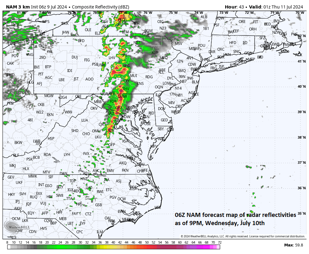
One high-resolution forecast model (NAM-3km) features a line of strong-to-severe thunderstorms later tomorrow evening across the central portions of the Mid-Atlantic region. The threat for heavy rain and strong storms in the DC-to-Philly-to-NYC corridor will likely be on the northwest side of I-95. Map courtesy Weather Bell Analytics, NOAA
On Wednesday, with the high heat and humidity still intact, the chances for showers and thunderstorms will increase. The remnant low of Beryl will become absorbed by an incoming upper-level trough and track well to the north and west of the I-95 corridor on Wednesday, but its role in an enhanced chance for heavy rain will not be unimportant. First, there will be plenty of tropical moisture associated with Beryl riding to the north on Wednesday on the front end of the incoming trough of low pressure. Second, the remnant low of Beryl will help to push a frontal system to the east coast and this system will stall-out and act as a conduit for moisture to ride along from south-to-north between the mid-week and weekend.

Heavy rain will be a threat later tomorrow and tomorrow night in the Mid-Atlantic region and severe weather is also on the table (e.g., damaging wind gusts). Forecast map by NOAA’s Storm Prediction Center
As a result, with hot and humid air in place and the frontal system nearby, the atmosphere will become quite unstable by later tomorrow and expect to see the development of numerous showers and thunderstorms in the Mid-Atlantic region; especially, to the northwest of I-95. With tropical moisture, any shower or thunderstorm that forms later tomorrow can result in some very heavy rainfall and flash flooding may become a concern. In addition, enough shear may develop in the atmosphere to help in the formation of some severe thunderstorm activity later tomorrow in the Mid-Atlantic region that’ll increase chances for strong wind gusts on a localized basis.
As the front locks in along the east coast on Thursday, the chance for showers and thunderstorms will continue and there should be a bit of relief in the high heat and humidity of recent days with highs likely confined to the 80’s along much of the I-95 corridor. The threat for showers and thunderstorms is likely to continue on Friday and Saturday with the upper-level trough and stalled-out frontal system still hanging around the eastern seaboard. This will result in additional showers and thunderstorms as we end the work week and begin the weekend and the overall setup can lead to some very heavy rainfall and perhaps flash flooding risks. The front should finally dissipate by the time we get to the second half of the weekend and the upper-level trough slides to the east of here which should result in a diminished chance of rain throughout the Mid-Atlantic region.
Meteorologist Paul Dorian
Arcfield
arcfieldweather.com
Follow us on Facebook, Twitter, YouTube
Monday’s video discussion with a focus on the upcoming heavy rain threat: