11:00 AM | ***Strong-to-severe thunderstorm threat this afternoon into tonight along the DC-to-Philly-to-NYC corridor...downpours likely...possible damaging wind gusts***
Paul Dorian

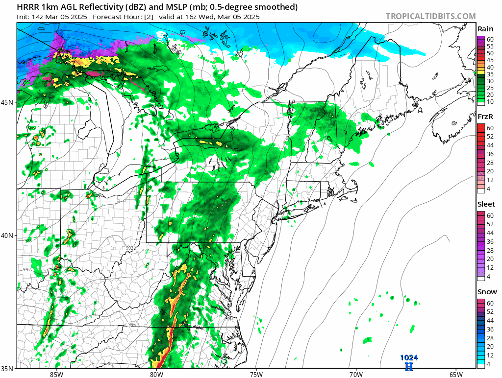
A high-resolution model (HRRR) forecast loop of radar reflectivities for this afternoon and evening suggest that a pretty solid squall line will form near the I-95 corridor region and a second line will attempt to form on its heels (and the second line will run into a more stable atmosphere). Maps courtesy NOAA, tropicaltidbits.com
Overview
Ingredients are in place for strong-to-severe thunderstorm activity later today into early tonight along the DC-to-Philly-to-NYC corridor which will include downpours and the possibility of damaging wind gusts. In addition, a few isolated tornadoes are on the table later today in the Mid-Atlantic region and an enhanced risk of tornadoes will take place farther to the south from southeastern Virginia into the Carolinas. Meanwhile, in the storm’s cold sector, there are blizzard conditions today across portions of Iowa, Minnesota and Wisconsin where 60+ mph winds can cause considerable blowing and drifting of snow.

A powerful low-level jet will feature winds of 70-to-80 knots later this afternoon from the Mid-Atlantic region to the Carolinas. This raises the possibility of damaging wind gusts during any afternoon/evening thunderstorm activity that is likely to form as a strong cold front slides from west-to-east towards the coast. Map courtesy NOAA, tropicaltidbits.com
Details
A major storm system that originated over the Pacific Ocean continues to wreak havoc today across a wide part of the nation. This system generated copious amounts of damaging wind reports on Tuesday focused on the Lower Mississippi Valley and central Gulf coast, and there were at least 8 reports (unconfirmed) of tornadoes. The severe weather risk today has shifted to the eastern states with strong-to-severe thunderstorms likely later today into early tonight along the DC-to-Philly-to-NYC corridor. Downpours are likely and there can be hail during any thunderstorm activity, and there is a big concern for damaging wind gusts. The risk of damaging wind gusts is heightened by a powerful low-level jet that will reach 70 to 80 knots just a few thousand feet off the ground level. Isolated tornadoes are also on the table in the Mid-Atlantic region with the highest chance likely to the south of the PA/MD border. An enhanced risk of tornadoes later today will take place farther to the south from southeastern Virginia to the Carolinas where low-level wind shear will be at higher levels compared to locations up the east coast.

Strong low pressure is wreaking havoc on much of the eastern half of the nation today with blizzard conditions in its cold sector (Iowa, Minnesota, Wisconsin) and the threat of severe weather up and down the eastern seaboard from the Mid-Atlantic to northern Florida. Map courtesy NOAA, tropicaltidbits.com
Another player on the field is a very strong surface low pressure system that this morning featured “category 1” hurricane-type central pressures while positioned over eastern Wisconsin. In the cold sector of this storm, blizzard conditions are taking place in such places as Iowa, Minnesota and Wisconsin where gusts past 60 mph are resulting in considerable blowing and drifting of snow.

“Blizzard Warnings” are in effect across portions of Iowa, Minnesota and Wisconsin (orange) and “Tornado Watches” are in effect across the Carolinas (in yellow). Map courtesy NOAA/WPC
The rough timetable for potential strong-to-severe thunderstorm activity in DC is 1-5 pm, 2-6 pm in Philly, and 4-8 pm in the NYC metro and along coastal New Jersey. Note: a second line of showers and thunderstorms will try to form behind the initial main squall line. However, this second line will be limited in its severity as it runs into a more stable atmosphere by the time it reaches the I-95 corridor this evening. All of the rain activity should wind down by late tonight and Thursday promises to be another windy day in the Mid-Atlantic region featuring strong winds that can gust to 45 mph or so from a northwesterly direction. It’ll be cooler as well on Thursday and there will be partial sunshine as high pressure returns to the area.
Meteorologist Paul Dorian
Arcfield
arcfieldweather.com
Follow us on Facebook, Twitter, YouTube
Video discussion: