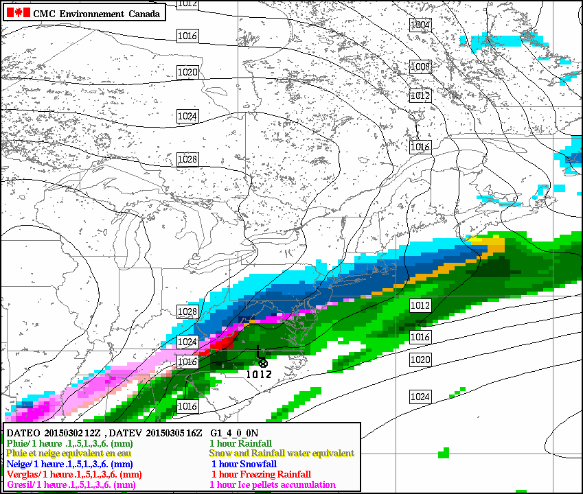
 [12Z Canadian model forecast map for mid-day Thursday (blue=snow].
Discussion
Overview
March began with snow and ice on Sunday, more snow and/or ice is coming for tomorrow afternoon and evening and then, after a temporary warmup on Wednesday, a significant snow event is possible from late Wednesday night into Thursday. Before we get into the details on the very active next few days, let us first throw out some new numbers regarding the amazingly cold February which just ended.
February recap for DC, Philly, NYC
At Reagan National Airport in Washington, DC (DCA), February 2015 was the coldest month at any time of the year since January 1994. DCA saw seven days completely below freezing which is the most in any month since 1979. Dulles Airport in Virginia (IAD) recorded its 2nd coldest February ever and BWI Airport in Maryland saw its coldest February since 1934 (source Washington Post/Capital Weather Gang).
In Pennsylvania, February 2015 was the coldest February ever in State College, Erie, Williamsport and Harrisburg. At Philly International Airport (PHL), this was the 7th coldest February ever recorded going back to 1874 and the coldest month at any time of the year since December 1989 (source phillywx.com).
In New York City, February 2015 turned out to be the third coldest February ever and the coldest since 1934. It was the 2nd coldest February ever recorded in Newark, NJ.
Finally, here is just a sampling of places which set their all-time monthly (cold) temperature records: Buffalo (NY), Islip (NY), Hartford (CT), Bridgeport (CT), Syracuse (NY) and Bangor (ME).
Tuesday afternoon and evening - snow, ice threat
After a very cold night in which temperatures drop into the teens, clouds will thicken up early Tuesday ahead of the next precipitation event. Precipitation is likely to break out during the mid-day or early afternoon hours in DC, mid-to-late afternoon hours in Philly and New York City, and it should be cold enough for that initial precipitation to be of the frozen variety. In DC, the precipitation could start as all snow, but a wintry mix is more likely whereas in Philly and NYC the precipitation is liable to begin as all snow. In all areas, any initial snow will change over to a wintry mix fairly quickly later tomorrow or early tomorrow night and, yes, there can be some snow and ice accumulations by midnight. Temperatures tomorrow night should slowly rise and any mixed precipitation is likely to change to plain rain by early Wednesday.
Wednesday – milder with plain rain
Wednesday promises to be a milder day with periods of rain. Temperatures could even flirt with the 50 degree mark on Wednesday in portions of the I-95 corridor. The more important story; however, will be the approach of another Arctic cold frontal system. This front will pass through the region late Wednesday and this will begin a downward trend in temperatures that could set the stage for significant snow on Thursday.
Late Wednesday night/Thursday – potential significant snowfall
Once the Arctic front reaches the east coast, it will stall out due to the alignment of the upper-level winds which will prevent any significant movement to the southeast. At the same time, copious amounts of moisture will begin heading northeast along the stalled out frontal boundary zone and into the I-95 corridor. At the same time, colder air will be pushing in from the northwest and the result could very well be a changeover rain early in the day to an accumulating snow and significant accumulations are possible up and down the I-95 corridor.

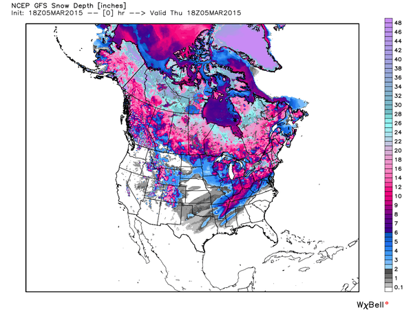 [Pretty amazing to see 54% of the US with snow cover in early March (through mid-day Thursday); map courtesy Weather Bell Analytics]
 [12Z GEM model forecast map of total snowfall accumulations during this upcoming event; courtesy tropicaltidbits.com]
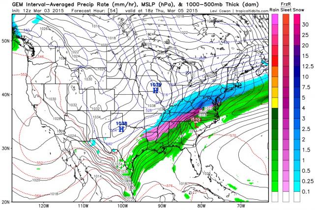 [Tuesday 12Z Canadian forecast map for Thursday mid-day (blue=snow)]
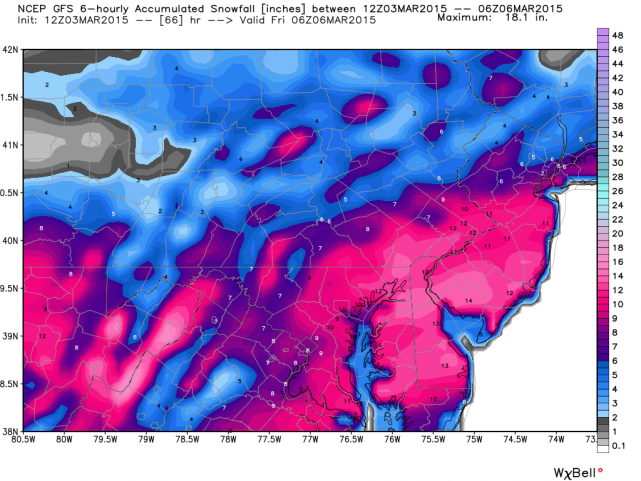 [Tuesday 12Z GFS snowfall forecast map for the late Wednesday night/Thursday storm]
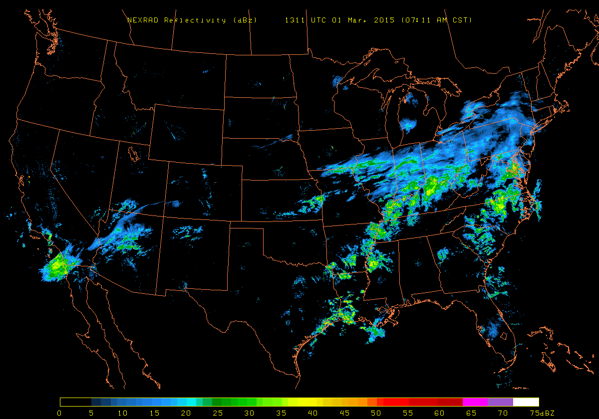 [US radar image with plenty of moisture headed to the Mid-Atlantic region; NEXRAD image courtesy University of Wisconsin]
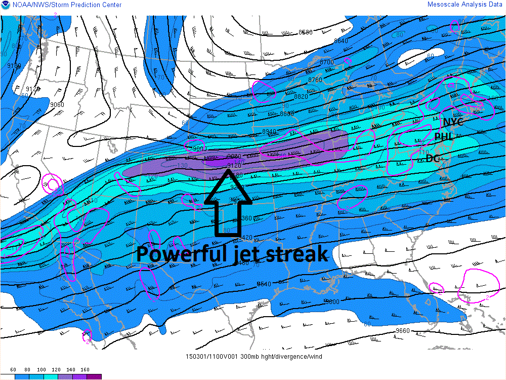 [Sunday AM 300 millibar winds showing powerful jet streak (purple) which is headed right into the Mid-Atlantic region; courtesy NOAA]