12:15 PM | **Possible crippling snowstorm for Friday/Saturday**
Paul Dorian

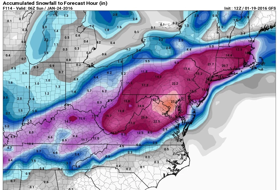
12Z GFS total snow accumulation map by late Saturday night; map courtesy pivotalweather
Overview
All systems are go on the latest GFS model for a major – and potentially crippling – snowstorm at week’s end in the Mid-Atlantic region including the DC-to-Philly-to-NYC corridor. Low pressure will pull out of the Tennessee Valley on Friday and head towards the Mid-Atlantic coastline. This storm will undergo explosive intensification between Friday and Saturday as it will be supported by a vigorous wave of upper-level energy. At the same time, “banana-shaped” cold high pressure will set up to the north and northwest of the surface low pressure system – a classic signature for Mid-Atlantic snowstorms.
This is the type of storm that can easily generate 1-2 feet of snow in DC-to-Philly-to-NYC strip, but there are still a few days to go and some details still have to be ironed out. In addition to the snowfall, winds will become a major factor as a tight pressure gradient develops between the strengthening low pressure system and the high pressure to the north and northwest. As a result, blowing and drifting is likely to become an issue and beach erosion will be a concern at coastal regions; especially, given that a full moon is coming on Saturday when winds will be at their highest (potentially 60 mph at the coast, 40 mph inland).

12Z GFS surface forecast map for Friday night; map courtesy Weather Bell Analytics
Latest GFS forecast model run
The 12Z GFS surface maps for Friday night and Saturday night depict movement of the storm from near the Carolina coast to east of the New Jersey coastline with a tight pressure gradient as represented by the black lines. A conveyor belt of moisture wraps around the storm by Saturday – another classic signature for Mid-Atlantic snowstorms - and this could result in a very snowy Saturday along with strong winds. The GFS snowfall map features a “bullseye” around the DC metro region, but this location could certainly change some by later this week and extend to the northeast. If there is any change in the latest GFS model, it is that the storm track is slightly farther to the southeast of yesterday’s model run which actually would lessen the threat of mixing with or a changeover to rain/sleet in the I-95 strip. We'll see over the next day or two if that storm track slight shift to the southeast is the beginning of a trend. Later today, we'll check out the latest European model run.

12Z GFS surface forecast map for Saturday night; map courtesy Weather Bell Analytics
Timing
Snow could arrive in the DC region during Friday morning and then move into Philly during the early-to-mid afternoon hours, NYC late afternoon.
Stay tuned – 3 days to go on this one.
Meteorologist Paul Dorian
Vencore, Inc.