11:20 AM | **Arctic blast arrives tonight with snow in some areas…accumulating snow/ice late Friday night/early Saturday then plain rain…another system to watch for Sunday/Sunday night**
Paul Dorian
12Z GFS forecast map of 850 mb temperature anomalies early tomorrow night ("first freeze"); map courtesy tropicaltidbits.com, NOAA
Overview
No doubt this is a very complicated forecast in the Mid-Atlantic region for the next five days or so as we’ll experience a deep freeze which will be followed by a rather rapid thaw which will then be followed by another freeze. In addition, there will be multiple systems that can impact us with accumulating snow, ice and/or rain.
12Z GFS forecast map of 850 mb temperature anomalies early Saturday evening ("thaw"); map courtesy tropicaltidbits.com, NOAA
Details
One upper-level system will arrive later tonight at about the same time the Arctic front reaches us and it looks like snow will break out over the Delmarva Peninsula and southern/central New Jersey and an inch or two could actually accumulate in those areas by early tomorrow. The overnight snow could also expand into the big city metro regions of DC, Philly and NYC where a coating to an inch can accumulate and slippery conditions would likely develop rapidly given the expected sharp drop in temperatures..
12Z GFS forecast map of 850 mb temperature anomalies early Monday afternoon ("second freeze"); map courtesy tropicaltidbits.com, NOAA
On Thursday and Thursday night, the Arctic winds will howl and wind chill values can fall at times to zero or below in the I-95 corridor. Snow showers can fall at just about any time on Thursday and Thursday night; especially, in areas north of the PA/MD border and it’s possible a heavier snow squall or two makes it all the way to the coast from the Great Lakes and this could cause a quick accumulation. Temperatures on Thursday will do no better than the 20’s for highs and then they'll bottom out at bitter cold levels by early Friday morning. Specifically, low temperatures in the upper single digits are possible in the NYC metro region early Friday, near 10 degrees across many of the the Philly N and W suburbs, and not far from 15 degrees in the DC area. After a brisk start to day on Friday, the winds will lighten up noticeably during the afternoon hours which will make the Arctic cold a little easier to take.
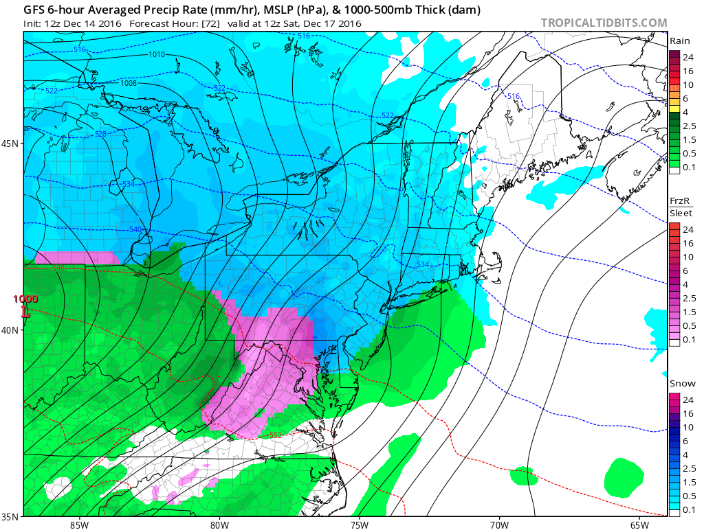
12Z GFS surface forecast map for early Saturday morning (snow in blue, ice in pink, rain in green); map courtesy tropicaltidbits.com, NOAA
This Arctic air mass will then begin to retreat to the north late Friday night and early Saturday morning, but not before moisture arrives from the Great Lakes region. Snow is likely to break out in the DC, Philly, NYC corridor around midnight or so and there can be accumulations by the time early Saturday morning rolls around. During the morning hours on Saturday, the snow will transition to a period of ice from southwest-to-northeast in the I-95 corridor and then completely changeover to plain rain by mid-day or so, but there can be additional snow/ice accumulations before that changeover takes place. Temperatures could very well climb into the 40’s by later Saturday after the complete retreat of the low-level Arctic air with some more rain likely during the afternoon hours. Preliminary snowfall estimates for late Friday night and early Saturday are as follows: a coating to a couple of inches in and around DC, 2-4 inches in and around the Philly and NYC metro regions.
12Z GFS surface forecast map for early Saturday afternoon (snow in blue, ice in pink, rain in green); map courtesy tropicaltidbits.com, NOAA
The rain will tend to lighten up for awhile on Saturday night, but then it resumes on Sunday as a system develops along the next Arctic front which will close in from the Midwest. Temperatures may actually peak near 50 degrees early Sunday, but then colder Arctic air will arrive and it is possible that there be a changeover from rain to sleet and snow later Sunday/ Sunday evening in the I-95 corridor. Following the passage of this next Arctic frontal system, the beginning of next week promises to very cold day for the middle of December.
12Z GFS surface forecast map for early Sunday evening (snow in blue, ice in pink, rain in green); map courtesy tropicaltidbits.com, NOAA
Stay tuned…told you it was complicated.
Meteorologist Paul Dorian
Vencore, Inc.
vencoreweather.com


