11:00 AM | *Spring begins with accumulating snow in parts of the I-95 corridor*
Paul Dorian
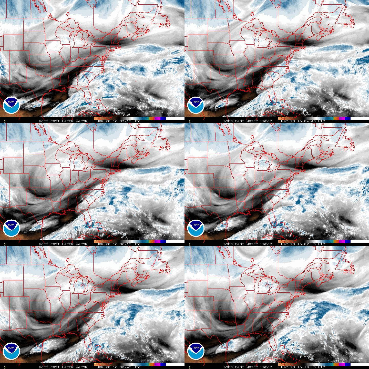
Latest water vapor imagery loop featuring "spinning motion" over the Midwest associated with upper-level low; courtesy NOAA
Overview
Spring has officially begun and apparently no one notified Mother Nature. The first full day of spring will turn out much colder than Christmas Day in the Mid-Atlantic region and Northeast US. In addition, accumulating snow is quite likely from later today through tonight in parts of the I-95 corridor as low pressure intensifies off the Mid-Atlantic coastline. Cold, dry Arctic air poured into the Mid-Atlantic region during the past 24 hours and this has allowed for some breaks of sunshine today and the possibility for some accumulating snow by later tonight.
12 hour change in the 500 millibar height field; courtesy NOAA
Snowfall
There was plenty of “front-runner” moisture on Saturday associated with this two-part system and it actually resulted in some snowfall south of the Mason-Dixon Line across West Virginia, northern Maryland and Virginia, and even into the northern and western suburbs of DC. Much of the action later today and tonight will take place north of the Mason-Dixon Line from Philly northeastward to the eastern sections of northern New England. While the DC metro region can get another coating to an inch so of snow later today from this unfolding coastal low pressure system, more substantial snow is likely to fall as one progresses northeastward along the I-95 corridor; especially, in those areas close to the coastline (as suggested by the 09Z SREF snowfall forecast map below). For example, anywhere from a coating to 2 or 3 inches of snow can fall in the Philly and NYC metro regions later today and tonight, up to 4 or 5 inches can fall across interior and coastal New Jersey, central and eastern Long Island, and 6-10 inches of snow is possible by early tomorrow morning in eastern New England roughly from Providence, RI to just south of Boston to eastern Maine. Snow will be of the wet variety and should, for the most part, only accumulate on non-paved surfaces in the after dark hours. Also, the highest snowfall amounts will tend to take place on the south and east sides of the metro regions.
09Z SREF total snowfall map for upcoming storm with increasing accumulations as one progresses up the I-95 corridor; courtesy NOAA
Key players
The latest water vapor imagery loop (top) shows quite well a "circulation" pattern in the atmosphere over the Midwest as this is the location of a vigorous upper level low. This upper atmosphere feature is currently diving to the south-southeast right towards the area of greatest height falls in the Deep South (above) and this southward plunge will play a key role in the ultimate strength and track of surface low pressure. By dropping so far to the south, the positioning of this upper low will allow for rather significant intensification of the unfolding surface low pressure system and it should help keep it fairly close to the coast later today and tonight rather than "out-to-sea". Low pressure will trek from the southeastern states later today to the coastal waters of the Mid-Atlantic and this system should intensify as it moves in a northeastward direction. As the storm strengthens, its precipitation shield will expand in coverage on the northwest side of the surface low pressure center - first breaking out over the Delmarva Peninsula and then eventually spreading up along the I-95 corridor as the storm moves northeast.
In addition to the upper level low, another key factor in the overall scenario involves the now well-entrenched Arctic air mass that is currently in place in the Mid-Atlantic region. Overnight temperatures dropped into the lower 30’s across much of the region and, perhaps more importantly, dew points dropped considerably as the drier Arctic air flooded in from the north. This drop in overall humidity (correlated to the drop in dew point temperatures) will play a key role later today as precipitation at the onset will tend to quickly cool the lower atmosphere by several degrees through the "evaporative cooling" process. As a result, while precipitation may begin in the form of light rain or perhaps a mix of rain and snow, it should change to all snow not long after onset time in much of the region after those lower boundary-layer temperatures back into the 30's.
Let’s hope the rest of spring goes better than this – stay tuned.
Meteorologist Paul Dorian
Vencore, Inc.


