11:45 AM | *Potential for a major east coast storm later this week*
Paul Dorian
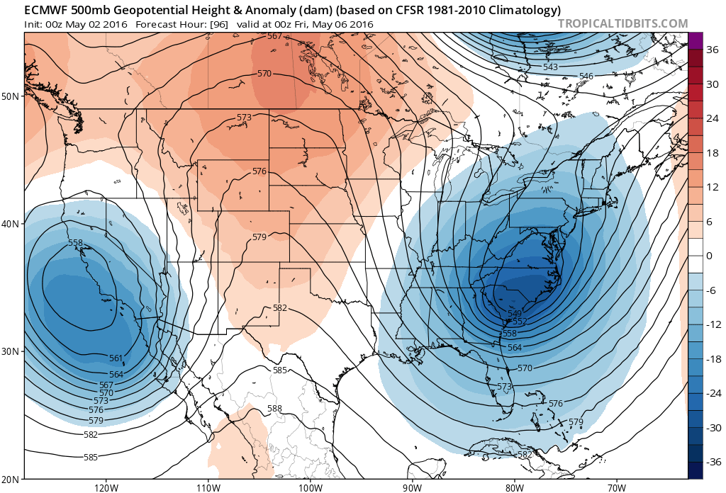
00Z Euro model forecast of 500 mb height anomalies for Thursday night with a deep upper-level trough in the eastern US; map courtesy tropicaltidbits.com
Overview
This will be a very unsettled week in the Mid-Atlantic region with multiple chances of rain and numerous low pressure systems will be contributing factors. The latest surface map (not shown) features low pressure sitting just off of the Mid-Atlantic coastline. Another low pressure system will intensify over the Delmarva Peninsula during the next 12 hours or so and it’ll produce more rain around here from early tonight into Tuesday including the threat for strong-to-severe thunderstorms. A third low pressure system will form along the Mid-Atlantic coastline later in the week. That third low pressure system looks like it will meander around for a couple of days (classic "omega" block) as a deep upper-level trough develops along the east coast, and this setup could ultimately result in a strong nor’easter during the late Thursday/Friday time frame. This potential late week nor’easter could bring soaking rains to the I-95 corridor and it could be just cold enough for snowflakes to fly in higher elevation locations from western Pennsylvania to eastern West Virginia.
00Z Euro model forecast of surface pressure anomalies for Thursday night with a strong surface low pressure system off the Mid-Atlantic coastline; map courtesy tropicaltidbits.com
Short-term heavy rain and thunderstorm threat
Warmer air is currently trying to push to the northeast along the I-95 corridor, but it is quite a struggle as chilly, dense low-level air is reluctant to give up its ground. As a result of this on-going "atmospheric battle", scattered showers will form early this afternoon and then - as the atmosphere destabilizes later in the day - thunderstorms are likely to form south of the PA/MD border. These showers and thunderstorms will likely become more widespread early tonight in the Mid-Atlantic region and some of the storms can be on the strong-to-severe side with heavy rainfall. The advancement of the warmer air this afternoon will have a much better chance at "succeeding" in the DC metro region (where the sun should break out) compared to areas farther to the northeast such as in Philly and NYC. By late tonight, low pressure will form along this temperature boundary zone and it'll likely produce more rain around here on Tuesday and some of that can be heavy at times.
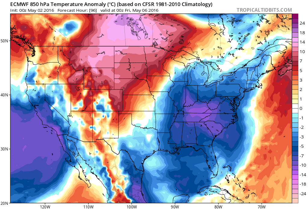
00Z Euro model forecast of 850 mb temperature anomalies for Thursday night with well below normal temperatures in the eastern US; map courtesy tropicaltidbits.com
Late Thursday/Friday coastal storm threat
By mid-week, colder air will begin to drop southeastward across the Great Lakes from central Canada and a deep upper-level trough will start to form in the eastern US. As the deep upper-level trough intensifies later in the week, strong surface low pressure is likely to develop near the Mid-Atlantic coastline and once it forms, it will be slow-moving and spin around for a couple of days. A classic "omega" block in the upper atmosphere will form later in the week and slow down the movement of the east coast storm. Deep upper-level troughs will form along both US coastlines and strong ridging will unfold in the middle of the country resulting in an upper-level flow pattern that resembles the Greek letter "omega". The result of this blocking pattern could be periods of rain in the late Thursday/Friday time frame and some of it may be heavy at times. Also, given the cold air mass that will be feeding into this system from Canada, snowflakes may fall in higher elevation locations from western Pennsylvania to eastern West Virginia. Once this system finally pulls away early next week, prospects for sustained warmer weather should jump significantly. Last night’s 00Z European model run featured a deep upper-level trough in the eastern US and western US with strong high pressure ridging in between (top). Also, last night's European model run featured strong surface low pressure off the Mid-Atlantic coastline and well-below normal temperatures for this time of year in the eastern US.
Meteorologist Paul Dorian
Vencore, Inc.


