
2:00 PM | *Strong Arctic high pressure to our north spells trouble for the weekend with the potential of ice and/or snow*
Paul Dorian
12Z GFS surface forecast map for early Saturday featuring strong Arctic high pressure to our north; map courtesy tropicaltidbits.com, NOAA/EMC
Overview
While we’ll get noticeably milder on Wednesday, Thursday and Friday in the Mid-Atlantic region, building Arctic high pressure to our north at the end of the week will result in much colder conditions for the weekend. A frontal system will pass through the region on Friday and this will set off some drastic changes around here as we head into the weekend. To make matters worse, moisture will head our way from the south-central US and the combination of this moisture with strong surface Arctic high pressure to our north may result in a prolonged period of ice and/or snow.

12Z GFS forecast map of height anomalies at 500 millibars for early Saturday; map courtesy tropicaltidbits.com, NOAA/EMC
Short term ice threat
We are now transitioning to a much milder weather pattern for the Mid-Atlantic region that will become noticeable on Wednesday and last into the day on Friday. The current entrenched Arctic air mass is reluctant to give up its ground; consequently, there can be some snow, sleet or freezing rain during the next 12 hours or so; especially, on the northern and western side of the I-95 metro regions so watch out for icy road conditions. On Wednesday, the milder air will win out as the current Arctic air mass goes in full retreat to our north and temperatures could reach the 50 degree mark for highs. The warmest day of the week is likely to be on Thursday as a strengthening southwest wind will boost temperatures to near 60 degrees in the metro regions of DC, Philly and NYC. Changes begin on Friday, however, as while we may stay mild early in the day, it won’t get nearly as warm as Thursday and a frontal system will work its way through the region setting the stage for a much colder weekend.

12Z GFS forecast map of 850 mb temperature anomalies for early Saturday; map courtesy tropicaltidbits.com, NOAA/EMC
Weekend frozen precipitation threat
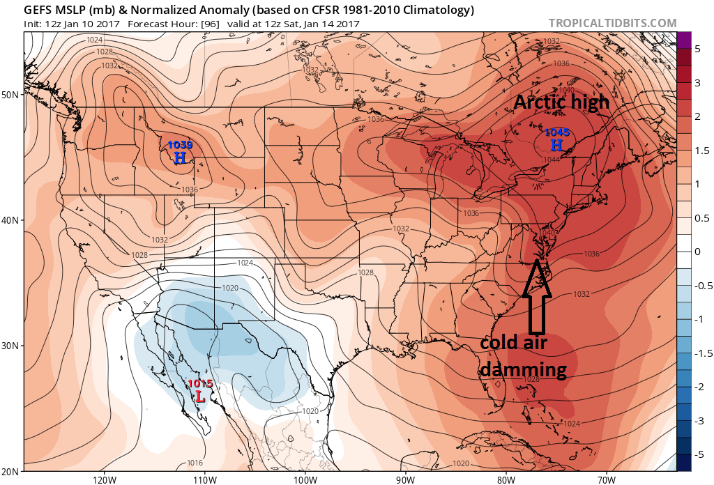
By the weekend, significant high pressure ridging in the middle part of the atmosphere (500 millibar, ~18,000 feet) will build into the eastern states and temperature anomalies at 850 millibars (~5000 feet) will continue at above-normal levels. We don’t live at those levels, however, and ground-level temperatures are likely to be on the cold side thanks to the strong surface Arctic high pressure situated to our north. The 12Z GFS forecast map for early Saturday portrays a classic cold air damming situation in which cold air pours down the eastern side of the Appalachians into the I-95 corridor extending southward from an Arctic high pressure system to the north. The bending of the isobar pattern (black lines of equal pressure) on this model forecast map is a classic signature of cold air damming. Given the potential combination of incoming moisture with high pressure ridging in the middle part of the atmosphere, above-normal temperatures at 850 mb, and strong surface Arctic high pressure to our north, ice could end up being a problem this weekend somewhere in the I-95 corridor region. However, it could also end up being just cold enough for snow - instead of ice - which is probably the lesser of two evils.
Stay tuned – strong Arctic high pressure to the north spells trouble.
Meteorologist Paul Dorian
Vencore, Inc.
vencoreweather.com