
2:00 PM | **Cold blast becomes noticeable tonight...accumulating snow tomorrow night/early Friday...weekend threat**
Paul Dorian

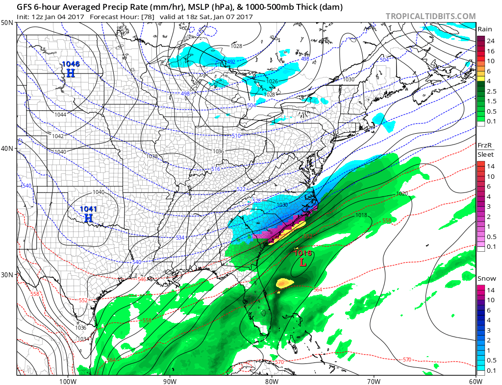
12Z GFS forecast map for late tomorrow night (snow in blue); map courtesy tropicatidbits.com, NOAA
Overview
A significant blast of Arctic air will become quite noticeable tonight as the sun goes down, temperatures drop, and the winds pick up out of the northwest and it’ll stay colder-than-normal right into the early part of next week. In addition to the cold, accumulating snow is likely around here tomorrow night and early Friday from one low pressure system and then there will another system to monitor this weekend near the eastern seaboard. Although odds currently favor the worst effects of that weekend system to stay just to our south and east, there are reasons to believe that it could shift to the north and west somewhat from current model projections.
Details on the Mid-Atlantic Outlook
The front edge of very cold Arctic air is pushing towards the I-95 corridor and the changing temperatures will become quite noticeable after the sun goes down and the winds pick up out of the northwest. Temperatures by tomorrow morning could drop to near the 20 degree mark in many suburban locations along the I-95 corridor and it’ll stay below normal right into the early part of next week. A rebound in temperatures is likely during the early-to-middle part of next week in much of the eastern US.
12Z GFS forecast map for early Saturday afternoon; map courtesy tropicaltidbits.com, NOAA
Two separate waves of low pressure will head towards the Mid-Atlantic coastline over the next few days and there is a good chance of accumulating snow from the first system tomorrow night and early Friday. Specifically, snowfall on the order of a coating to 2 or 3 inches is likely in the entire region from DC-to-Philly-to-NYC from tomorrow night into early Friday and road conditions will likely become slippery for the Friday morning commute.
The upper-level system associated with the second system will dive deeper into the southern states compared to the first and there are signs that it will then phase with some northern jet stream energy. The result will likely be a strengthening storm just off the Mid-Atlantic coastline on Saturday and it is possible that its biggest impact will stay to our south and east with some places in the Southeast US receiving significant accumulating snow (e.g., Carolinas, Georgia). There are reasons to believe, however, that there can still be an important north and west shift of this weekend's storm track from current computer model projections which would result in more significant snow in the I-95 corridor region of DC, Philly and NYC. This shift to the north and west can happen, in my opinion, based on the overall unfolding upper-level pattern and, in part, based on the warm waters of the western Atlantic Ocean. One final important factor regarding this weekend's system, the air will be so cold in the eastern US, it will not take much liquid equivalent precipitation to generate important accumulating snowfall amounts.
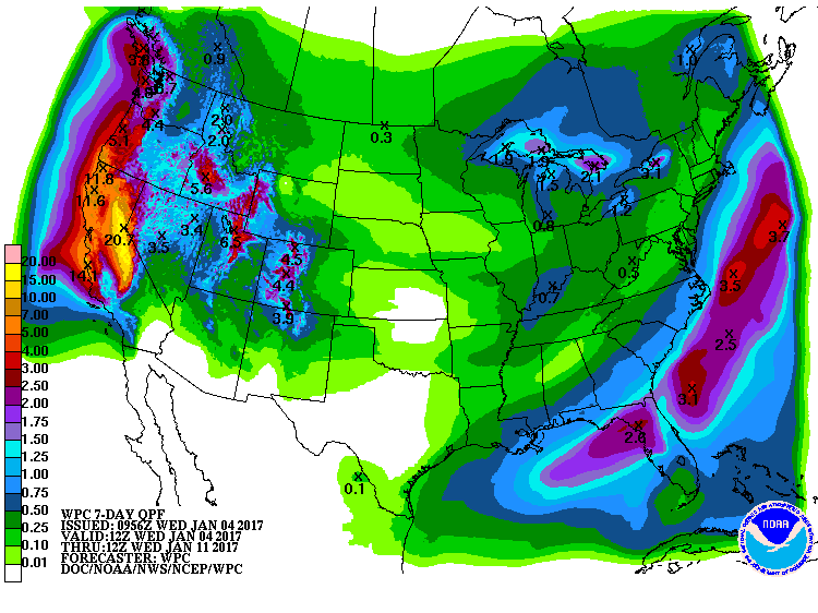
NOAA's forecast of precipitation totals over the next 7 days with more than twenty inches in eastern California
The California Blitz
Not only is the weather exciting here in the eastern US with the cold wave and potential accumulating snow, the state of California is going to experience some mind-boggling precipitation amounts over the next week or so. In fact, there can be up to 20 inches of liquid equivalent precipitation in the Sierra Nevada Mountains of eastern California and this could translate into 10 feet or more of snow in some of the highest elevations in that area.
As always, stay tuned.
Meteorologist Paul Dorian
Vencore, Inc.
vencoreweather.com