2:00 PM | ***More snow on the way for the DC, Philly, NYC metro regions and brutal cold follows for Saturday night and Sunday***
Paul Dorian

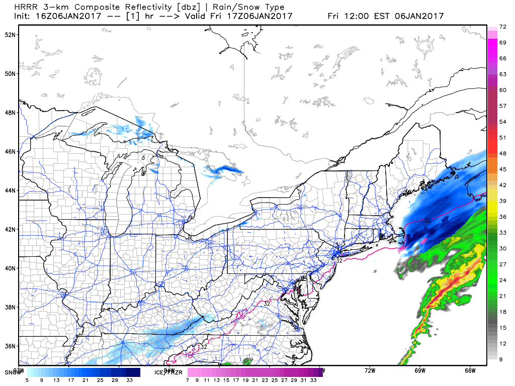
High-Resolution Rapid Refresh (HRRR) computer forecast model shows the snow (in blue0 advancing into the southern Mid-Atlantic by early tomorrow morning. The last frame in this loop is valid for 5AM on Saturday and this particular short-term model only goes out as far as 18 hours from the initialization time (on an hourly basis). Maps courtesy Weather Bell Analytics at weatherbell.com
Overview
A wall of cold has swept over the nation and, earlier in the day, every state in the union except for Florida had temperatures below the freezing mark somewhere within its borders. In addition, 25 states had temperatures below zero and 6 states actually had locations with temperatures below -20°F. The cold is not the only weather problem for the nation – soon there will widespread regions experiencing significant snow or ice. In fact, there will be frozen precipitation over the next 24 hours extending from Texas to New England and this includes many unusual areas in the Deep South and Southeast US. The DC-to-Philly-to-NYC corridor will also be under the influence of this developing major storm system and snow will return here by early tomorrow. Following the Saturday storm, brutal cold air will flood into the eastern US from the north and there may be some all-time record lows reached in portions of the Carolinas helped along by the expected fresh and deep new snowpack.

A wall of cold has spread across the nation and this map shows surface air temperatures (purple represents areas below freezing); map courtesy AccuWeather (Jesse Farrell)
Details
A wave of upper-level energy will dive deep into the southern states by early tomorrow and it will then phase with some northern stream upper-level energy. The result of this phasing will be a rapidly intensifying storm system just off the Mid-Atlantic coastline by later tomorrow. One current sign that there is lots of energy available in the atmosphere for this developing system to tap into is the preponderance of thunderstorm activity that is now exploding over the Gulf of Mexico (see "lightning strikes" map below). Significant snow will accumulate from this storm in areas that are not too familiar with it all the way from Alabama to southeastern Virginia and some spots in this zone could see a foot or more by tomorrow night. Snow will also spread northward early tomorrow morning right into the Mid-Atlantic's I-95 corridor and continue into the afternoon hours. The air mass during this upcoming event will be quite cold around here and that suggests just a little "liquid-equivalent" precipitation can go a long way in terms of snow accumulations (i.e., dry, fluffy snow forms in the cold air and this type of snow piles up quicker than wet snow).
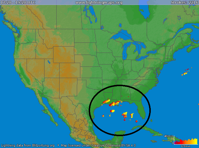
Current lightning strikes over the Gulf of Mexico (circled region) indicates it is in general quite an energetic atmosphere and this will contribute to a rapidly intensifying storm system along the east coast on Saturday; map courtesy lightningmaps.org, blitzortung.org
The preliminary snowfall estimates for the Mid-Atlantic's I-95 corridor are as follows: a coating to a couple of inches in the immediate DC, Philly, NYC metro regions, 2-4 inches in areas just to the south and east of these big cities (e.g., interior southern New Jersey, southern Maryland), and 6 inches or more near the coastline (e.g., Salisbury, Maryland, Cape May, New Jersey, eastern Long Island). A word of caution on these estimates, there will be a sharp gradient in snowfall accumulation in the NW quadrant of this coastal storm and a slight shift in storm track can have a significant impact on snow totals here in the immediate I-95 corridor. In addition to the storm track, a slight change in the projected strength of this storm or the extent of its precipitation field can also have a big impact on snowfall amounts around here. In other words, it won't take much for a more significant snowfall to occur on Saturday in the DC, Philly and NYC metro regions. In terms of timing, the snow is likely to reach the DC area by 3 or 4 am and continue to around mid-day, reach Philly by 8 or 9 am and continue into the early-to-mid afternoon hours, and reach New York City by late morning and continue there into the late afternoon or early evening.
Following the snow, there will be downright brutal cold air for much of the eastern US coming from the north and portions of the interior Southeast US can experience monthly or even all-time record lows by Sunday morning. In fact, some spots could drop to 5 or 10 degrees below zero in interior sections of the Carolinas (e.g., Raleigh) aided by the expected fresh and deep snowpack and the clearing skies likely to follow the storm tomorrow night. The northern and western suburbs of DC, Philly and NYC could see low temperatures not far from 10 degrees by early Sunday morning and again early Monday morning as the bitter cold air will stick around through the early part of next week.
California Pounding to Continue
Not only is the weather exciting in the southern and eastern US with the serious cold wave and accumulating snow, the state of California is going to experience some mind-boggling precipitation amounts over the next week or so. In fact, there can be up to 25 inches of liquid equivalent precipitation in the Sierra Nevada Mountains of eastern California over the next several days and this could translate into 10 feet or more of snow in some of the highest elevations in that particular area. Needless to say, these upcoming series of storms will have a major impact on the California drought which actually began to wane in severity many months ago.
Meteorologist Paul Dorian
Vencore, Inc.
vencoreweather.com
Extended video discussion: