1:20 PM | *Some wild weather next couple of weeks*
Paul Dorian
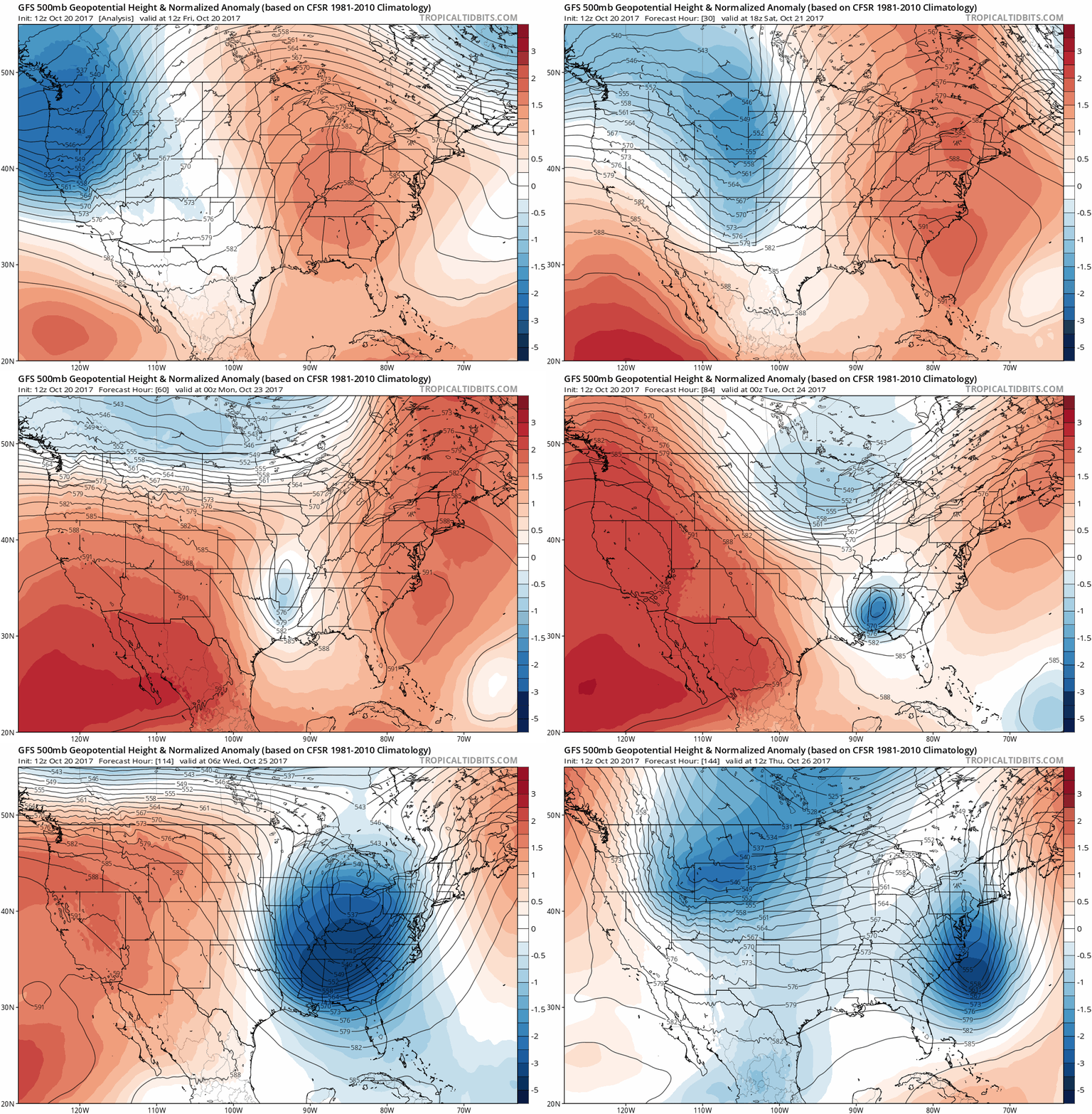
12Z GFS forecast of 500 mb height anomalies between today and next Thursday (in 6-hour increments). This weekend's strong high pressure ridging in the eastern US (orange) evolves into a deep upper-level trough of low pressure (blue) by the middle of next week. Maps courtesy tropicaltidbits.com, NOAA/EMC
Overview
This week has been about as quiet as it gets this time of year in the eastern part of the nation with very strong and relatively stationary high pressure dominating the scene for several days. In fact, that same high pressure system will continue to control the weather for the Northeast US/Mid-Atlantic region right through the upcoming weekend. Beyond that, however, a rapidly changing weather pattern will likely result in some wild weather for the eastern states over the next couple of weeks that could include soaking rain, possible severe thunderstorm activity, and occasional impressive cold air outbreaks.
NOAA's forecast map of total precipitation during the next 5 days (Today-Wednesday) with soaking rain in the eastern half of the nation. Map courtesy NOAA/WPC
Discussion
This weekend will see a continuation of our recent weather pattern in the I-95 corridor with cool nights and pleasant days, but by early next week attention will turn to our northwest. On Monday, a chilly air mass for this time of year will be diving to the southeast from the Upper Midwest and vigorous energy in the upper part of the atmosphere will result in a strong deep upper-level trough by mid-week in the eastern US that will take on a slightly negative tilt adding to the instability. The core of this chilly air mass is headed towards the Southeast US where temperatures will plunge to as much as 20°C below normal by mid-week, but even the I-95 corridor region from DC-to-Philly-to-NYC will turn colder-than-normal for next Wednesday and Thursday.
12Z GFS forecast map of 500 mb vorticity and winds next Tuesday evening features a strong wave of energy swinging through the Mid-Atlantic region and this could set off some severe thunderstorm activity. Map courtesy tropicaltidbits.com, NOAA/EMC
Ahead of the cold front, moisture will ride northward from the Gulf of Mexico and this should result in a soaking rain for the eastern states with the main action in DC, Philly and New York City setting up for Tuesday and Tuesday night. A strong wave of energy in the upper-part of the atmosphere could very well result in some severe weather activity across the Southeast US on Monday and then in the Mid-Atlantic region on Tuesday. Temperatures will drop to below-normal levels following the frontal passage for next Wednesday and Thursday, but then they should rebound some by the end of the work week in this rapidly changing weather pattern.
Yes, this is a long range forecast (384 hours) by the 12Z GFS and still in the "purely speculation" phase; nonetheless, it is featuring a very impressive cold air outbreak for the first week of November in the middle part of the country. Map courtesy tropicaltidbits.com, NOAA/EMC
Instead of settling down at the end of next week, the weather pattern may actually produce a repeat performance in the eastern states during the weekend of the 28th and 29th with yet another deep upper-level trough moving perhaps associated with more soaking rain event and possible severe weather activity. Looking way ahead, there are early signs for a real impressive cold air outbreak for the middle of the country during the first week of November.
Stay tuned…could be quite interesting weather during the next couple of weeks.
Meteorologist Paul Dorian
Vencore, Inc.
vencoreweather.com


