
12:20 PM | *”Gales of November”…major storm to bring very strong winds to Great Lakes, Mid-Atlantic, Northeast US*
Paul Dorian

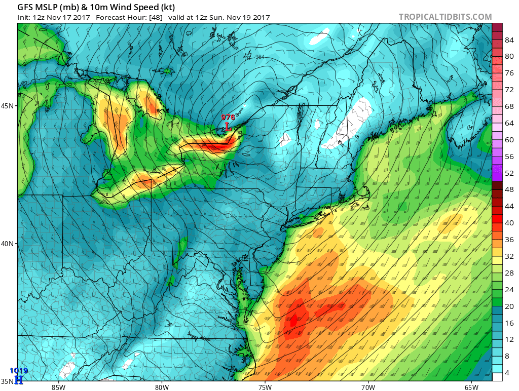
12Z GFS forecast map for Sunday morning with major storm located near Lake Ontario and a tight isobar pattern throughout the Great Lakes and Mid-Atlantic regions which suggests strong winds; courtesy tropicaltidbits.com, NOAA/EMC
Overview
Somewhat reminiscent of the storm that brought down the “SS Edmund Fitzgerald” in November 1975, a major storm will develop over Great Lakes this weekend and produce dangerous wind gusts in that area and winds here in the I-95 corridor could gust to 50 mph or so on Sunday behind the passage of a powerful cold front. This next cold shot will continue an overall colder-than-normal weather pattern for November that looks like it will stay intact to the end of the month with additional cold air outbreaks to follow. In fact, another cold air outbreak is likely to reach the Mid-Atlantic region at mid-week and result in a cold Turkey Day for the entire Northeast US.
12Z GFS forecast map of lower atmosphere wind gusts on Sunday morning with the highest gusts concentrated over the Great Lakes and western Atlantic; courtesy tropicaltidbits.com, NOAA/EMC
Discussion
A major storm and associated powerful cold front will have a big impact on much of the eastern US this weekend including right here in the I-95 corridor region from DC-to-Philly-to-NYC. On Saturday, this powerful cold front will charge to the southeast and produce strong thunderstorm activity in the Tennessee and Ohio Valleys. Low pressure will move over the western Great Lakes and intensify rapidly so that by the time it reaches Lake Ontario early Sunday the central pressure will be down to about 976 millibars (28.82 inches). Winds this weekend could gust to 60 mph over the Great Lakes and perhaps reach 50 mph or so right here in the I-95 corridor on Sunday. Temperatures will be below-normal for this time of year on Sunday in the Mid-Atlantic following the frontal passage with highs generally to the 40’s and even lower wind chill values.

12Z GFS forecast map of 850 mb temperatures anomalies for Thanksgiving Day (early afternoon)...colder-than-normal in the eastern US; courtesy tropicaltidbits.com, NOAA/EMC
The temperatures should moderate some by mid-week, however, another cold shot will head our way and arrive around Wednesday night. This mid-week shot of cold air is likely to result in a breezy and cold day for Thursday, Thanksgiving Day, with temperatures doing no better than the 40’s in the afternoon. After that, some moisture will gather in the Gulf of Mexico and head towards the southeast US coastline on Friday and it’ll have to be closely monitored as it could come quite close to the Mid-Atlantic region. Additional cold air outbreaks will likely follow for later next weekend and beyond to the end of the month.
Meteorologist Paul Dorian
Vencore, Inc.
vencoreweather.com