
Wed 1:50 PM | **”Clipper” snow later tonight/early tomorrow can cause slippery spots…potential wild pattern setting up for later this month**
Paul Dorian
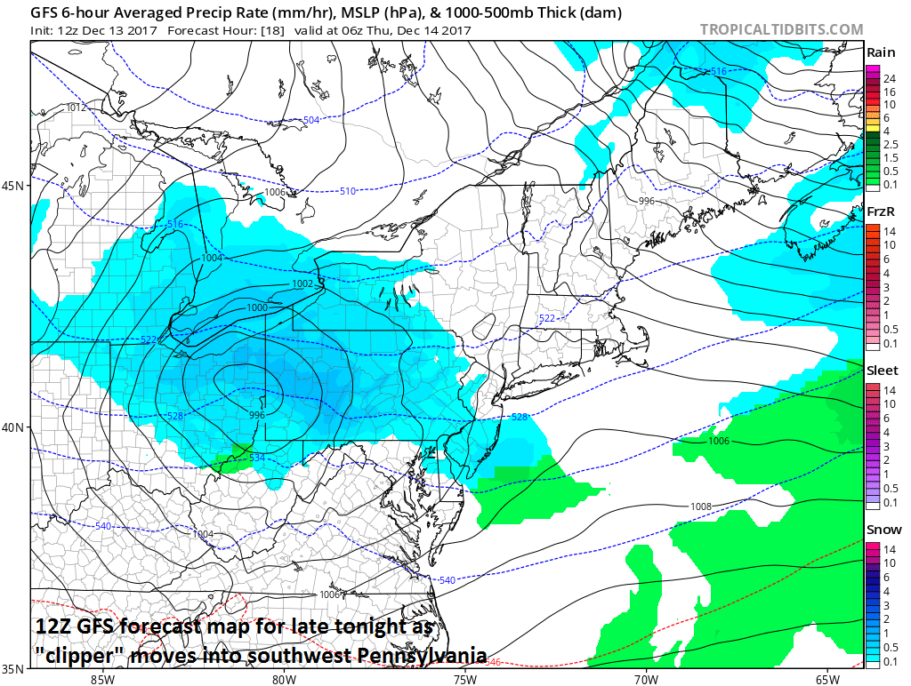
12Z GFS forecast map for late tonight (snow in blue); map courtesy NOAA/EMC, tropicaltidbits.com
Overview
Arctic air plunged into the Mid-Atlantic region late yesterday and temperatures today are well below-normal in DC, Philly and NYC. Meanwhile, a “clipper” low pressure system is dropping southeastward across the Upper Midwest and it should reach southwestern Pennsylvania by later tonight. As a result, snow is likely to break out later tonight in much of the Mid-Atlantic region; primarily, in areas to the north of the Mason-Dixon Line, but even the DC metro region can see some snow shower activity. Any snow that falls with this “clipper” system can quickly cause slippery conditions on untreated roadways given the very cold surface temperatures. Looking ahead to later this month, there are signals for continued cold air outbreaks into the eastern US – perhaps after a temporary milder stretch early next week – and the pattern may become quite stormy as well.
“Clipper” snow late tonight/early tomorrow
A fast-moving low pressure system (hence the term “clipper”) is heading southeast across the Upper Midwest and it will trek eastward across southern Pennsylvania late tonight and early Thursday. Snow associated with “clipper” systems generally falls to the north of the track and, in this case, that means Philly and NYC are likely to receive more snow than the DC metro region. However, all three metro regions can see some snow later tonight (despite the "dry" look of the GFS forecast map in areas to the south of the PA/MD border). In all areas, any snow that does fall can quickly create slippery road conditions as temperatures are (and have been for several hours) well below-freezing - unlike this past weekend when roads were relatively warm during our first snow event.
While moisture is limited with this system, accumulations on the order of a dusting to an inch or two are quite possible in Philly and NYC metro regions as snow-to-liquid ratios will be quite high given the very cold air mass in place across the region and a dusting of snow is possible in the DC metro region. In other words, a little moisture at these temperatures can go a long way in terms of snowfall. The approximate starting time for the I-95 corridor is as follows: 7-11 PM in DC, 9 PM-1 AM in Philly, and 11 PM-3 AM in the NYC metro region. The snow pulls out quickly early tomorrow morning as the “clipper” low pressure system pulls off the New Jersey coastline.

Compilation of MJO index forecasts by numerous computer models with "phase 8" reached at the end of the forecast period (December 27th) as indicated by the arrow.
Teleconnections and the outlook for later this month
Many different teleconnection indices exist and are used by forecasters to get some insight into potential medium and longer-range weather conditions in a particular part of the world. Two such “teleconnection” indices point to more cold weather for the Mid-Atlantic region – perhaps after a temporary milder stretch early next week. The Madden-Julian Oscillation (MJO) and Eastern Pacific Oscillation (EPO) indices suggest there is more cold air coming our way later this month and indications are that it might get quite stormy as well – perhaps right around the time Christmas Day rolls around.

Temperature composite maps for each MJO phase in the current three month period with the central and eastern US typically colder-than-normal (shown in blue) during "phase 8" (circled)
MJO
The MJO is a tropical disturbance that propagates eastward around the global tropics with a cycle on the order of 30-60 days. The MJO has wide ranging impacts on the patterns of atmospheric circulation and influences both precipitation and surface temperature patterns across the US. Research has found that the location of the MJO, or phase, is linked with certain temperature and precipitation patterns around the world. The MJO phase diagram illustrates the recent and forecasted progression of the MJO index through different phases which generally coincide with locations along the equator around the globe. The very latest mean model forecast of the MJO index propagates it from its current "phase 6" location into "phase 8" (indicated by arrow) as we progress towards late December (follow green line in figure above in a counter-clockwise fashion). Phase 8 for the MJO index this time of year typically signals colder-than-normal temperatures in the eastern U.S. (see circled area below in "phase 8" temperature anomaly chart).

Forecast of the EPO index is for it to drop sharply into negative territory later this month.
EPO
The EPO is a dipole pattern similar to the North Atlantic Oscillation (NAO) index in the Atlantic, but is located in the eastern Pacific. The negative phase of the EPO typically corresponds to widespread cooling over central and eastern North America. In fact, when the EPO goes sharply negative, there is a predisposition for colder air to head across the pole (cross polar flow) from Siberia into Canada and ultimately into the eastern US. Model forecasts not only suggest the EPO index will drop into negative territory in coming days, but it looks like a sharp drop is coming later this month – all suggestive of more cold weather in the eastern US.

Temperature anomaly composite map for negative EPO in December
Meteorologist Paul Dorian
Vencore, Inc.
vencoreweather.com
AM video discussion: