10:15 AM | **Brutal cold air plunges into the US next week**
Paul Dorian
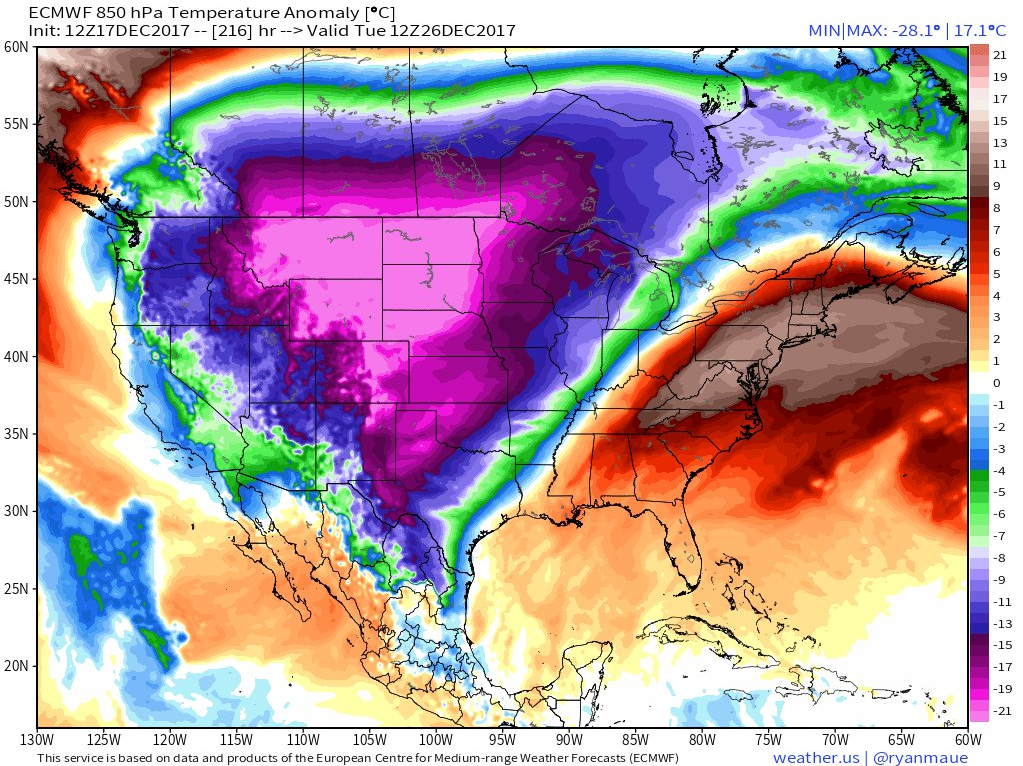
Yesterday's 12Z Euro model forecast map of 850 temperature anomalies for next Tuesday, December 26th with brutal cold across the Northern Plains; map courtesy weather.us (Dr. Ryan Maue)
Overview
This is looking like a relatively quiet week across the country compared to last, but next week could turn out to be quite active with storm threats and brutal cold air is likely to plunge into the US from way up north. The bitter cold air mass will first arrive in the Northern Plains by this weekend and then it should spread across much of the rest of the nation during the early part of next week. “Teleconnection” signals support the notion that it turns very cold next week in much of the nation and the new year is likely to start in the deep freeze for many areas.
MJO index forecast by the GEFS with "phase 8" reached at the end of the forecast period (December 31st) as indicated by the arrow.
Teleconnections
Two “teleconnection” indices point to more unseasonable cold weather coming to much of the nation as we move through Christmas week and into the new year. Specifically, the Madden-Julian Oscillation (MJO) and Eastern Pacific Oscillation (EPO) indices both suggest more below-normal cold air is coming to the nation and it very well result in brutally cold conditions for many areas.
Temperature composite maps for each MJO "phase" for this time of year with the central and eastern US typically colder-than-normal (shown in blue) during "phase 8" (circled)
MJO
The MJO is a tropical disturbance that propagates eastward around the global tropics with a cycle on the order of 30-60 days. The MJO has wide ranging impacts on the patterns of atmospheric circulation and influences both precipitation and surface temperature patterns across the US. Research has found that the location of the MJO, or phase, is linked with certain temperature and precipitation patterns around the world. The MJO phase diagram illustrates the recent and forecasted progression of the MJO index through different phases which generally coincide with locations along the equator around the globe. The very latest mean model forecast of the MJO index propagates it from its current "phase 7" location into "phase 8" as we progress towards the end of December (follow green line in figure above in a counter-clockwise fashion). "Phase 8" for the MJO index in the December/January/February time frame (circled above) typically signals colder-than-normal temperatures in the eastern half of the nation.
Forecast of the EPO index (left) shows a sharp drop into deep negative territory by Christmas Day and the temperature anomaly composite map (right) is shown for negative EPO during the month of December.
EPO
The EPO is a dipole pattern similar to the North Atlantic Oscillation (NAO) index in the Atlantic, but is located in the eastern Pacific. The negative phase of the EPO typically corresponds to widespread cooling over central and eastern North America. In fact, when the EPO goes sharply negative, there is a predisposition for colder air to head across the pole (a.k.a., "cross polar flow") from Siberia into northern Canada and ultimately into the central and eastern US and in late December/early January, this can result in brutally cold air. Model forecasts not only suggest the EPO index will drop into negative territory in coming days, but it indeed looks like a sharp drop is coming – all suggestive of more unseasonably cold weather across the central and eastern US.
06Z GEFS forecast map of the 500 mb pattern by the middle of next week (12/28) with air flowing from near the North Pole into the northern US (indicated by arrows); map courtesy NOAA/EMC, tropicaltidbits.com
The negative EPO will discharge cold from northern Canada into the US by the upcoming weekend, but exactly when it arrives in the eastern US is still somewhat of an open question and there are some differences between computer forecast models. The latest European model suggests warmer-than-normal conditions may hold on in the eastern US to Christmas Day (Monday), but NOAA's GFS model brings in the colder air just before the holiday arrives. The timing of the cold air's arrival in the eastern US may be quite important as their is liable to be some precipitation in the boundary zone between the retreating warm air to the southeast and the advancing cold air to the northwest. Stay tuned...Christmas Day may just turn out to be the transition day in the Mid-Atlantic region when the cold air arrives - ultimately, there is little doubt that the cold air will win out around here.
Meteorologist Paul Dorian
Vencore, Inc.
vencoreweather.com


