12:00 PM | **Widespread bitter cold headed to much of the nation…multiple snow threats as well including one by early Christmas morning in the Mid-Atlantic/Northeast US**
Paul Dorian

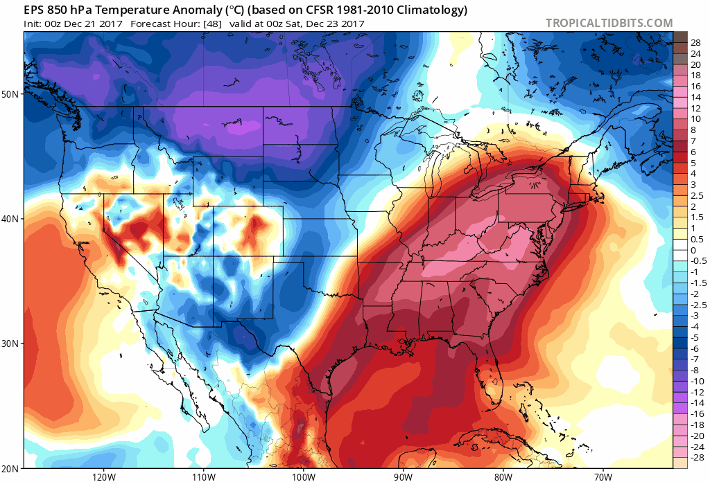
00Z EPS forecast maps of 850 mb temperature anomalies over an 8-day period in 24-hour increments from Friday night (12/22) to Saturday night (12/30) with widespread cold spreading across much of the nation. Courtesy tropicaltidbits.com
Overview
The weather pattern across the nation will become quite wild over the next couple of weeks with widespread bitter cold and multiple snow threats. After a mild and wet day on Saturday in the Mid-Atlantic, a strong cold front will pass through the region and usher in a colder air mass for Christmas Eve (Sunday). In fact, it looks like once this colder pattern sets up in the Mid-Atlantic region, it’ll stick around going well into the month of January. In addition to the upcoming cold, there are likely to be multiple snow threats going forward including one for the Mid-Atlantic and Northeast US on Sunday night and early Monday (Christmas Day) and then another possible accumulating snow threat at the end of next week.

12Z GFS forecast map of upper-level (250 mb) winds as of late Sunday night featuring a strong jet-streak in the Mid-Atlantic/Northeast US. This jet streak will help induce the formation of strong low pressure near the Mid-Atlantic coastline late Sunday. Map courtesy NOAA/EMC, tropicaltidbits.com
Details
A strong cold front will close in on the Mid-Atlantic region on Saturday and strong low pressure will ride up along the boundary zone producing rain in the area. Temperatures will turn quite mild ahead of the front with highs well up in the 50’s in most spots along the I-95 corridor. Colder air will then filter into the I-95 corridor on Sunday following the passage of the cold front and there could be partial sunshine to start the day. At this point, there are some mixed signals with respect to computer forecast models, but I believe there are strong reasons to believe cyclogenesis will take place with low pressure forming near the Mid-Atlantic coastline by late Sunday and this system could then produce some snow in the Mid-Atlantic/Northeast US by Christmas morning. The 12Z GFS computer forecast model run now predicts a more impressive-looking "negatively-tilted" wave of upper-level energy by early Christmas morning compared to its earlier "flatter" solutions at 500 mb. This latest model solution is more favorable for accumulating snow in the Mid-Atlantic/Northeast US compared to recent runs. Other computer forecast models such as the Canadian and Euro already had "negatively-tilted" waves of upper-level energy in the Mid-Atlantic region by early Monday morning.

12Z GFS forecast map of surface conditions for early Christmas morning (Monday) with low pressure off the Mid-Atlantic coastline and snow (in blue) in much of the Mid-Atlantic/Northeast US.
Two important factors favor the development of a storm near the Mid-Atlantic coastline by the end of Christmas Eve Day including: 1) a frontal (temperature) boundary zone and 2) strong jet-streak induced upward motion. The cold front that pushes through the region late Saturday will slow down as it slides off the coast and this will result in a northeast-to-southwest temperature gradient near the coast with colder air to the north and west and warmer air to the south and east. This boundary zone will be a favored area for storm development once an impressive-looking jet-streak moves overhead. Upward motion associated with this jet-streak rotating around the base of an upper-level trough should help in the development of strong low pressure system by Sunday night and the air should become just cold enough for snow by early Christmas morning in much of the Mid-Atlantic and Northeast US. Once this low pressure system pushes off to the northeast later Monday, even colder air will pour into the Mid-Atlantic region and we’ll be very cold on Tuesday and Wednesday with highs likely limited to freezing or below.

12Z GFS forecast map of surface conditions for Friday night, December 29th with low pressure near the Mid-Atlantic coastline and snow (in blue) in much of the Mid-Atlantic/Northeast US.
Late next week and this is, of course, still several days away, strong high pressure is likely to trek across the northern US and this could potentially set us up nicely for accumulating snow around the end of next week (~Friday, December 29th). This strong high pressure system could evolve into a “snow-favorable” “banana-shaped” feature to our north and northwest by the end of next week - anchoring cold air for the Mid-Atlantic region. At the same time, copious amounts of moisture may pull out of the south-central states and head right into this cold air mass that will be entrenched in the local region. The cold and active pattern is likely to then continue beyond this late December snow threat and well into the month of January.
Meteorologist Paul Dorian
Vencore, Inc.
vencoreweather.com
Detailed video discussion on the prospects of cyclogenesis near the Mid-Atlantic coastline late Sunday into early Monday: