12:10 PM | **Grassy accumulations of snow on Friday in parts of I-95 corridor…impressive weekend Arctic blast…Sunday storm to stay to our south…increasing threat for early-to-mid next week**
Paul Dorian

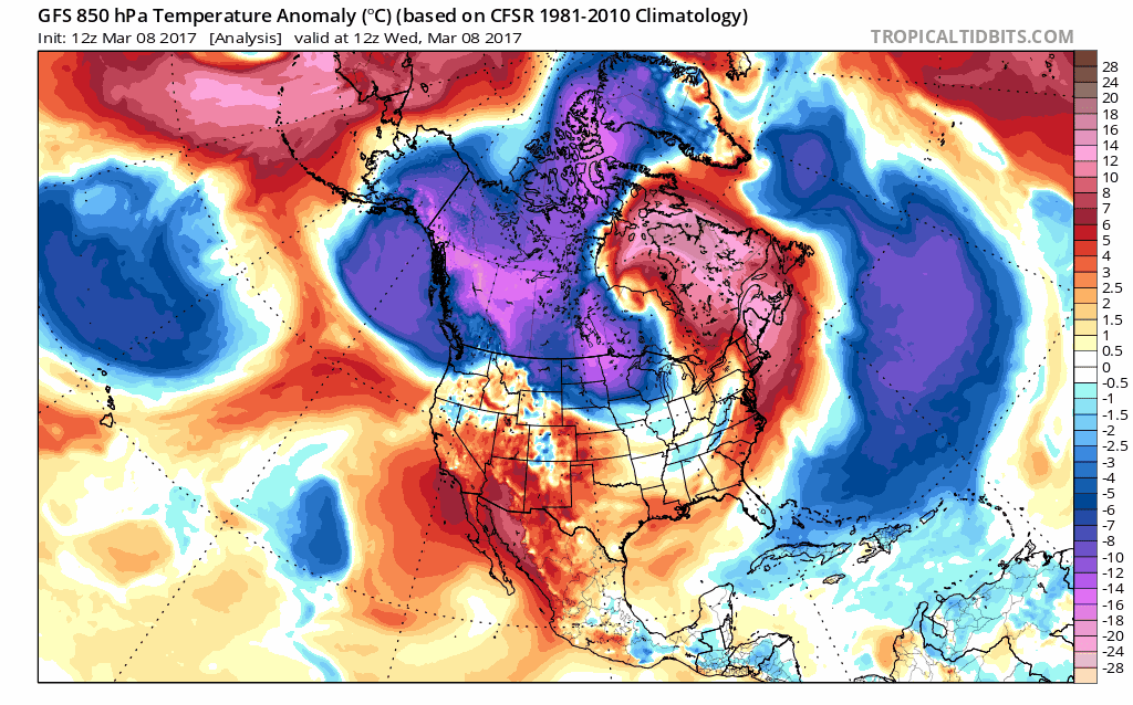
12Z GFS loop of 850 mb (~5000 foot level) temperature anomalies in 6-hour increments from early today until early Thursday; maps courtesy tropicaltidbits.com, NOAA/EMC
Overview
There are three different low pressure systems to monitor for the period extending from tomorrow night into the middle part of next week and accumulating snow is certainly on the table for the I-95 strip from DC-to-Philly-to-NYC, but perhaps the biggest story of all could be the Arctic blast that is coming for the weekend. “Air trajectory” maps show that the air coming into the Mid-Atlantic region for the weekend has its origins in the Canadian Arctic where they have experienced some of the coldest March weather in decades. An Arctic front will slide through the Mid-Atlantic region on Friday – accompanied by strengthening low pressure – and its passage will usher in air that will likely be some 15-20 degrees below normal for this time of year.
The low pressure that forms along this Arctic frontal boundary zone will generate rain at first in the Mid-Atlantic region, but then as colder air filters in from the north, a changeover to snow is likely early Friday and there can be some grassy accumulations in much of the I-95 corridor. After Arctic cold air pours into the area on Friday night and Saturday, the next storm system will be suppressed well to the south - sparing the DC-to-Philly-to-NYC corridor of any snow. A third system is likely to develop in the Mid-Atlantic region in the late Monday night or Tuesday time frame and it could intensify rapidly near the coastline with lots of cold air to in place.

"Backwards" air trajectory plot showing that the source region of the air reaching central Pennsylvania this weekend is the Canadian Arctic; plot courtesy tweet by Dr. Jon Nese, Penn State University, NOAA
Thursday night/Friday "rain-to-snow" scenario
Low pressure will form along an Arctic frontal boundary zone on Thursday night and rain is likely to break out in the I-95 corridor after midnight. As colder air pushes in from the north, there is going to be a changeover of rain-to-snow by Friday morning; primarily, in those areas north of the PA/MD border, but even the DC northern and western suburbs have a shot at seeing some snowflakes. The changeover of rain-to-snow will occur in a northwest-to-southeast fashion late Thursday night and early Friday.

12Z GFS forecast maps for 7am Friday (left) and 7pm Friday (right); maps courtesy tropicaltidbits.com, NOAA/EMC
As far as snow accumulations are concerned, there is the chance for a coating of snow on grassy surfaces in the northern and western suburbs of DC during the mid-to-late morning hours on Friday. In Philly and NYC, the changeover to snow could take place by the morning commute time with a coating to an inch or two possible on grassy surfaces in the Philly suburbs from this event, and 1-3 inches are possible in and around the New York City metro region.

12Z GFS forecast map of total snowfall for the Thursday night/Friday event; map courtesy tropicaltidbits.com, NOAA/EMC
Weekend Arctic blast
By Friday night, winds will intensify out of the north/northwest and Arctic air with its origins in the Canadian Arctic will flood into the Northeast US. An example as to just how cold this air mass has been at its source region, Mould Bay, Canada which is located on Prince Patrick Island in the Northwest Territories, set a record low temperature last weekend of minus 66.5 degrees (F) [credit to Washington Post/Capital Weather Gang]. In addition, just this morning (and during the Iditarod dog sled race), Fairbanks, Alaska saw its temperature plunge to minus 39 degrees (F) – this kind of extreme cold is rarely seen this late in the winter season. High temperatures on Saturday in Philly could struggle to reach the freezing mark at a time of year when normal highs are around 50 degrees.
This forceful plunge of Arctic air into the Northeast US will contribute to a suppressed storm track later in the weekend for a system that may actually end up in the Deep South. This southern route should spare the DC, Philly, NYC corridor from any snowfall during the second half of the weekend, but it’’ll stay very cold for this time of year.

12Z GFS surface forecast map for Tuesday morning; map courtesy tropicaltidbits.com, NOAA/EMC
Late Monday night/Tuesday storm threat
By early next week, vigorous upper-level energy will likely drop southeastward from central Canada into the Upper Midwest and this disturbance could spawn the formation of a rapidly intensifying low pressure system near the Mid-Atlantic coastline by Tuesday of next week. There will be plenty of cold air in the Northeast US at this time so the possibility of snow does exist for the late Monday night/Tuesday time frame. A reinforcing shot of Arctic air will follow this system and keep it well below normal around here right through the middle of next week.
Stay tuned, this is an active and complicated pattern.
Today’s extended video discussion:
Meteorologist Paul Dorian
Vencore, Inc.
vencoreweather.com