12:20 PM | **Two more rain events in the Mid-Atlantic between tonight and Friday…rain and perhaps a strong thunderstorm tonight/Tuesday...heavy rain/severe thunderstorm threat Thursday into Friday**
Paul Dorian

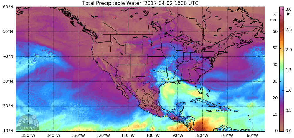
24-hour loop of total precipitable water showing moist air flowing northward from the Gulf of Mexico; loop courtesy University of Wisconsin/CIMSS
Overview
Two strong upper-level waves of energy will bring rain events to the Mid-Atlantic region between tonight and Friday and each event can feature strong or severe thunderstorms. The first wave arrives this evening and will produce rain in the overnight hours in the DC-to-Philly-to-NYC corridor and perhaps a strong thunderstorm or two. On Tuesday, the steadiest and heaviest rain will be gone, but there can be an occasional shower and perhaps a strong thunderstorm or two in the I-95 corridor as it turns noticeably windy and warmer.
The next event looks especially volatile and will feature a powerful low pressure system in the Northeast US and it'll impact the DC-to-Philly-to-NYC corridor from Thursday into Friday night. Rain is likely to be quite heavy on Thursday and Thursday night and there can be some severe thunderstorm activity in parts of the Mid-Atlantic region. On the backside of the storm, it’ll turn much cooler and very windy around here on Friday with additional rain showers likely. Accumulating snow is likely on Friday in the Ohio Valley and also in the higher elevation locations of western NY, western PA, western MD, West Virginia, and the Smoky Mountains of the Tennessee Valley. One final note, grounds are now pretty well saturated after the recent heavy rain event and this will raise concerns for localized flooding during each of the this week’s rain events.

12Z NAM forecast maps for this evening at the surface (left) and 500-mb level (right); courtesy tropicaltidbits.com, NOAA/EMC
Event 1 (Tonight/Tuesday)
Very moist air is currently flowing out of the Gulf of Mexico region and towards the Mid-Atlantic. At the same time, upper-level energy is pushing from the southern states towards the eastern Great Lakes and this combination will generate rain here later this evening. The rain will continue into the overnight hours from DC-to-Philly-to-NYC and there can be a few thunderstorms mixed in as well. On Tuesday, the steadiest and heaviest rain will be off to our northeast, but occasional showers are still likely in the I-95 corridor and there can be a strong thunderstorm or two as we’ll be in the unstable warm sector of this low pressure system. Temperatures will climb to or even above the 70 degree mark on Tuesday and winds will become quite noticeable from the south or southwest. The total rainfall amounts for this initial event are likely to increase from southwest-to-northeast in the Mid-Atlantic region with half an inch possible in DC, one inch in Philly, and 1.5 inches in and around the NYC metro region.

12Z NAM forecast maps for Thursday evening at the surface (left) and 500-mb level (right); courtesy tropicaltidbits.com, NOAA/EMC
Event 2 (Thursday into Friday)
This late week event looks especially volatile for the Mid-Atlantic region and is likely to feature a monster storm system in the Northeast US. This late week event will also last longer than event #1 as upper-level low will be deep and slow-moving. In addition, much colder air will wrap into the backside of the this late week system and this will likely result in accumulating snowfall on Friday for the Ohio Valley and Appalachian Mountains. In the I-95 corridor from DC-to-Philly-to-NYC, rain is likely on Thursday and Thursday night and some of it can be heavy at times. Furthermore, this will likely be an atmospheric setup that generates severe thunderstorm activity in the Mid-Atlantic region later Thursday into Thursday night. Once this deep and slow-moving upper-level system grinds away from here at the end of the work week, the weekend should show some gradual improvement. After a breezy and chilly day on Saturday, it should calm down and turn warmer on Sunday and Monday.
One final note, the northern half of California is about to get pounded once again. By the end of the week, heavy rain will return to northern California from another Pacific Ocean powerhouse storm system and the Sierra Mountains in the eastern part of the state are likely to get dumped on with more heavy snowfall.
Meteorologist Paul Dorian
Vencore, Inc.
vencoreweather.com
Extended video discussion: