1:45 PM | *Threat for strong-to-severe storms tonight in the I-95 corridor, but even more likely just to the west of here*
Paul Dorian

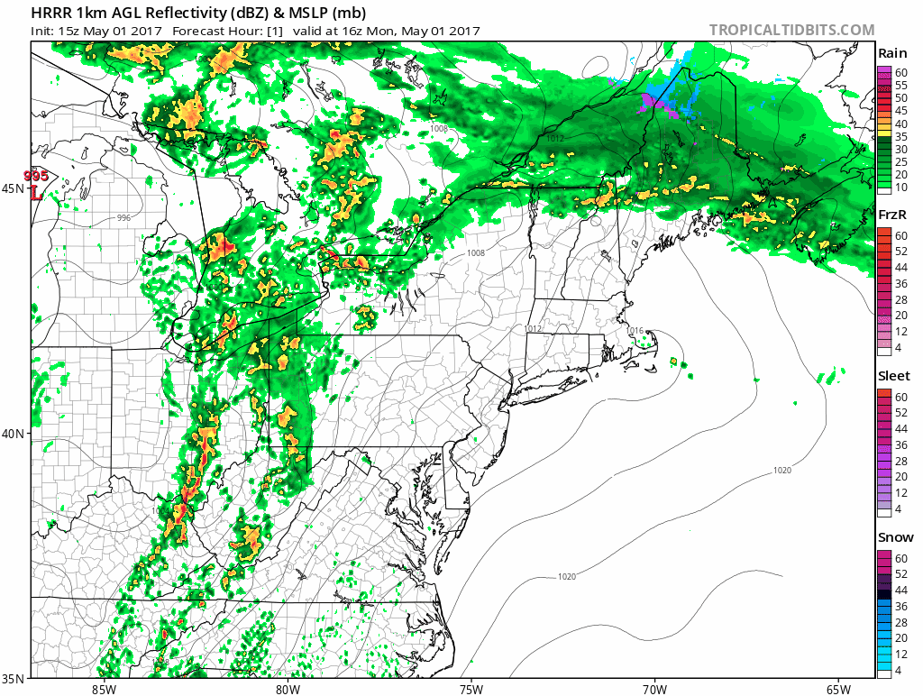
The latest high-resolution (HRRR) computer forecast model with hourly forecast maps of radar echoes over the next 18 hours; maps courtesy tropicaltibits.com, NOAA
Overview
A strong cold front is crossing the Ohio Valley today on its way to the eastern seaboard and thunderstorms have increased in intensity and coverage at mid-day across eastern Ohio and western West Virginia. The surface cold front currently stretches from the Great Lakes through eastern Ohio and into eastern Kentucky and will pass through the Mid-Atlantic region late tonight. While there is a threat for strong-to-severe thunderstorms tonight in the I-95 corridor, an even greater chance is likely just west of here in places like western and central Pennsylvania and West Virginia where a tornado watch has already been issued by NOAA's Storm Prediction Center.

The latest visible satellite image shows some breaks in the clouds at mid-day to the west of the I-95 corridor. Any brightening of skies or actual sunshine this afternoon would help to destabilize the lower atmosphere and increase the chance for strong-to-severe thunderstorm activity; image courtesy Penn State eWall, NOAA/GOES-13
Details
Despite an abundance of clouds, temperatures have jumped to near 80 degrees at last hour in the DC metro region and to near 70 degrees in and around Philly. The current cloud cover is, in fact, a limiting factor for potential severe storm activity as it helps to inhibit the rise in temperatures and this acts to stabilize the lower atmosphere. The latest visible satellite image, however, does show numerous breaks in the clouds and any brightening during the next few hours or intervals of actual sunshine would help to destabilize the lower atmosphere in the I-95 corridor and increase the chances for strong-to-severe thunderstorms later tonight.

Latest radar image with the main line to watch extending from eastern Ohio to western West Virginia; image courtesy NOAA
In addition to the cloud cover being a limiting factor, the expected timing of the frontal passage is not great for the prospects of severe weather in the I-95 corridor as it looks like it’ll come through towards morning - which is a more stable time of day compared to late afternoon/early evening. Nonetheless, the time period to watch for potential strong-to-severe thunderstorm activity in the I-95 corridor is from about 6 pm or so to around midnight and the greatest chance in the immediate I-95 corridor will be on its western side. The latest radar map shows an initial line of showers out ahead of the actual surface cold front, but that initial line should weaken over the next few hours and the solid line seen in eastern Ohio is the one to watch for the I-95 corridor as it slowly treks to the east this afternoon and evening.
The latest high-resolution (HRRR) computer forecast model shows organized thunderstorms west of here over the next several hours and then scattered showers and thunderstorms making it into the I-95 corridor early tonight. Any thunderstorm that makes it into the I-95 corridor can contain damaging wind gusts, downpours and perhaps even some hail.
Meteorologist Paul Dorian
Vencore, Inc.
vencoreweather.com
Extended video discussion on tonight's threat as well as the potential late week significant rain event: