10:30 AM | *Late week heavy rain event in DC, Philly, NYC to be followed by an extended period of colder-than-normal weather*
Paul Dorian
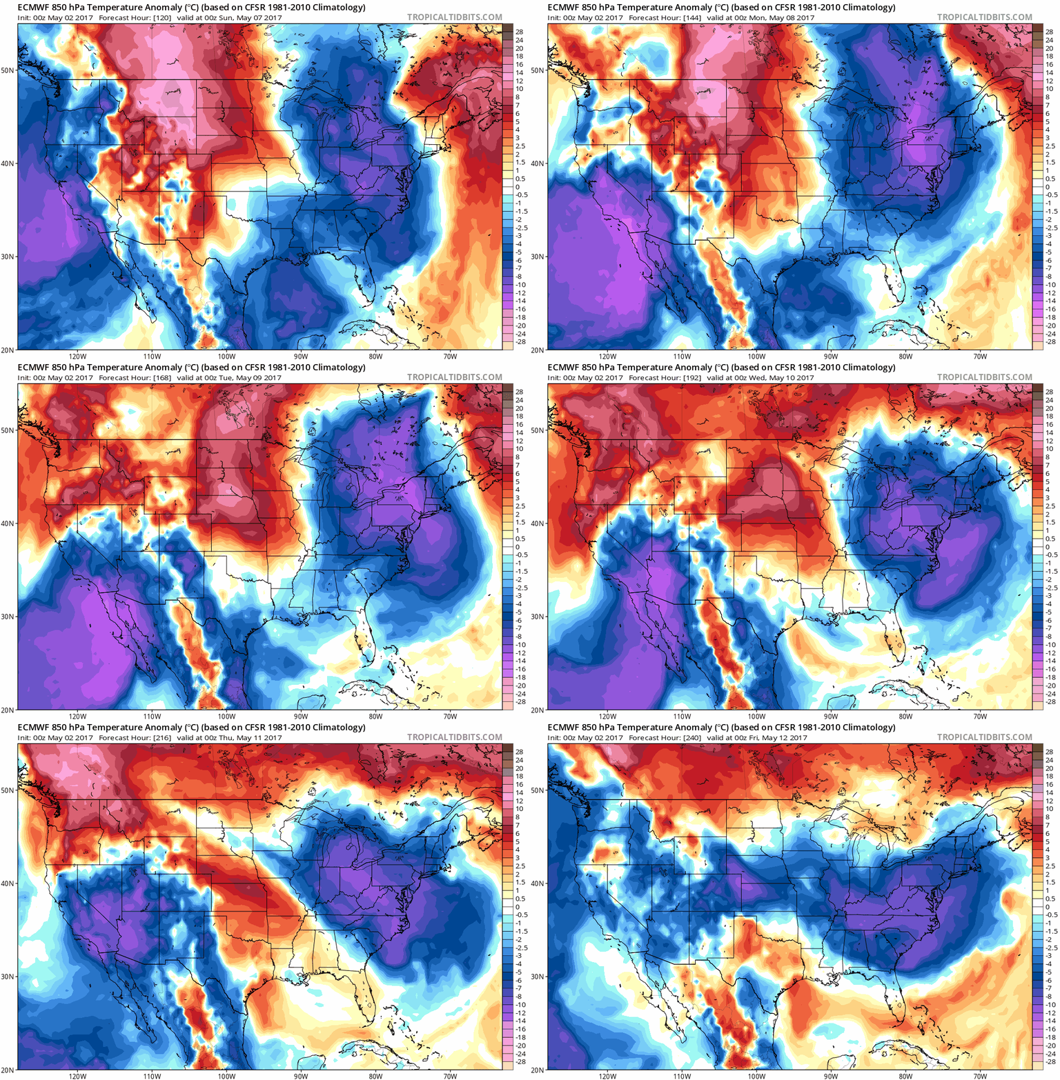
00Z Euro model forecast maps of 850 mb temperature anomalies from Saturday evening, May 6th to Thursday evening, May 11th; maps courtesy tropicaltidbits.com
Overview
There are two big weather stories for the I-95 corridor region from DC-to-Philly-to-NYC going forward over the next week-to-ten days: (1) a heavy rain event is coming that will be centered on late Thursday night and Friday and (2) an extended period of colder-than-normal weather from this coming Saturday through Thursday of next week and this overall stretch could even result in accumulating snow in some of the higher elevations of the Mid-Atlantic region. Strong low pressure will form at mid-week in the south-central US and head towards the Great Lakes region later Thursday. Rain should overspread the I-95 corridor from west-to-east late Thursday or Thursday night and continue into Friday resulting in a soaking rainfall for DC, Philly and NYC. Colder-than-normal air pushes in this weekend following the passage of a cold front and thanks to the formation of a classic “omega”-shaped blocking pattern in the upper atmosphere, it will stay colder-than-normal around here for several days.
00Z Canadian model surface forecast map for Friday morning with heavy rain along the I-95 corridor (indicated by yellow/orange region) and strong low pressure centered over West Virginia; map courtesy tropicaltidbits.com
Late week heavy rain event
Deep upper-level low pressure will unfold over the south-central US at mid-week and spawn the formation of a strong surface low pressure system. This strengthening low pressure area will then move towards the Great Lakes later Thursday and it should have a deep connection to the Gulf of Mexico which will increase the amount of moisture available to the overall system. On Thursday, heavy rain and potential severe weather can take place in the Southeast US and then rain should overspread the DC-to-Philly-to-NYC corridor later Thursday night. A soaking rain will continue into Friday around here and there can be some convection (i.e., thunderstorm activity) as warmer air pushes north along the eastern seaboard in the warm sector of the storm situated to our west. By the time the rain winds down later Friday, there can be rainfall amounts in excess of 1.50 inches in much of the I-95 corridor.
"Omega"-shaped blocking pattern in the upper atmosphere next week keeps deep upper-level low in the Northeast US for several days producing an extended period of colder-than-normal weather; map courtesy tropicaltidbits.com
Extended stretch of colder-than-normal weather
Once this low pressure system grinds its way into the Northeast US, it’ll become part of an overall “omega”-shaped blocking pattern in the upper atmosphere and this will assure very slow movement and result in an extended period of chilly weather for the I-95 corridor. The classic signature of an “omega”-shaped blocking pattern this time of year is to have deep upper-level low pressure near both coasts with abnormally high pressure ridging in the central US - and that will indeed become the look by next Tuesday (called "omega" since the upper-level flow pattern takes the shape of the Greek letter "omega"; detailed video discussion on the "omega" blocking pattern).
00Z GFS total snowfall forecast map for the next ten days with accumulations in higher elevation locations of the Mid-Atlantic region; map courtesy tropicaltidbits.com, NOAA/EMC
The colder-than-normal conditions this weekend and next week may also result in some accumulating snow in the higher elevation locations of the Mid-Atlantic with places like West Virginia and upstate Pennsylvania in the cross-hairs. With deep upper-level low spinning around over the Northeast US this weekend, the weather in DC, Philly and NYC will remain on the unsettled side with an occasional shower possible to go along with the unusual chill for this time of year. The 00Z Euro computer forecast model of 850 millibar temperature anomalies features colder-than-normal conditions in the Mid-Atlantic region from Saturday, May 6th to Thursday, May 11th with some areas getting as low as 20 degrees (C) below-normal for this time of year.
Meteorologist Paul Dorian
Vencore, Inc.
vencoreweather.com
Extended video discussion:


