12:00 PM | *First half of June to bring more cool weather to the Mid-Atlantic*
Paul Dorian
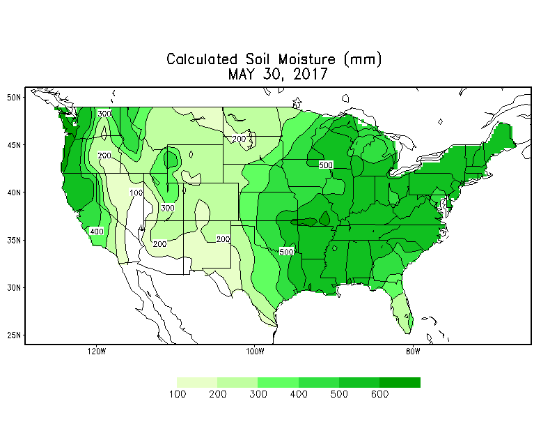
High soil moisture currently exists throughout the eastern US and this is a contributing factor to the expectation of more cooler-than-normal weather in the Northeast US as we progress through the first half of June; map courtesy NOAA/CPC
Overview
May is very likely to end up cooler-than-normal in the I-95 corridor region from DC-to-Philly-to-NYC and it looks like the same overall pattern will continue through the middle of June. Upper-level low pressure has dominated the scene in the Northeast US during the past several weeks and there are signs that this scenario will continue for awhile longer and contribute to more cool air outbreaks and more rain events. Another contributing factor to the cooler-than-normal weather in this region is the "soil moisture" which is quite high given all the recent rainfall and this scenario shows no sign of changing significantly anytime soon.
00Z EPS 500 mb height anomaly forecast for days 1-5 (left) and 6-10 (right); maps courtesy tropicaltidbits.com
Discussion
The average 500 millibar height anomaly for the next five days from the 00Z Euro Ensemble model forecast features below-normal heights (blue) in the Northeast US and even more widespread below-normal in days 6-10 which takes us to the 10th of June. This type of upper-air pattern will keep us unsettled and allow for cool air outbreaks around here and likely lead to more significant rain events during the next couple of weeks. The 850 millibar temperature anomaly pattern for the next five days (below) indicates generally cooler-than-normal (blue) in the Northeast US and then even more widespread below-normal conditions in days 6-10.
00Z EPS 850 mb temperature anomaly forecast for days 1-5 (left) and 6-10 (right); maps courtesy tropicaltidbits.com
As far as additional rainfall is concerned, there is the chance for scattered showers and thunderstorms later today in the Northeast US and again later Friday from a couple of different frontal systems, but the more ominous setup may come Sunday into Monday. Early signs point to a potential soaking rain event late in the weekend and into the early part of next week and temperatures are likely to trend to below-normal levels by the early and middle parts of next week as deep upper-level low pressure rebuilds across the Northeast US.
Soil moisture is already high in much of the eastern US and shows no sign of changing significantly in the near future with more substantial rain likely on the horizon. When soil moisture is high, it becomes a limiting factor for heat waves as the sun’s energy is used up in part in the evaporation of moisture in the ground rather than in the heating of the soil which, in turn, heats the atmosphere. In fact, high soil moisture was an important factor in the “2017 Mid-Atlantic Summertime Outlook” of normal-to-slightly below normal temperatures for the summer season in this region.
Meteorologist Paul Dorian
Vencore, Inc.
vencoreweather.com


