12:00 PM | **Heavy rain and severe thunderstorm threat from late today into tonight...tropical update**
Paul Dorian
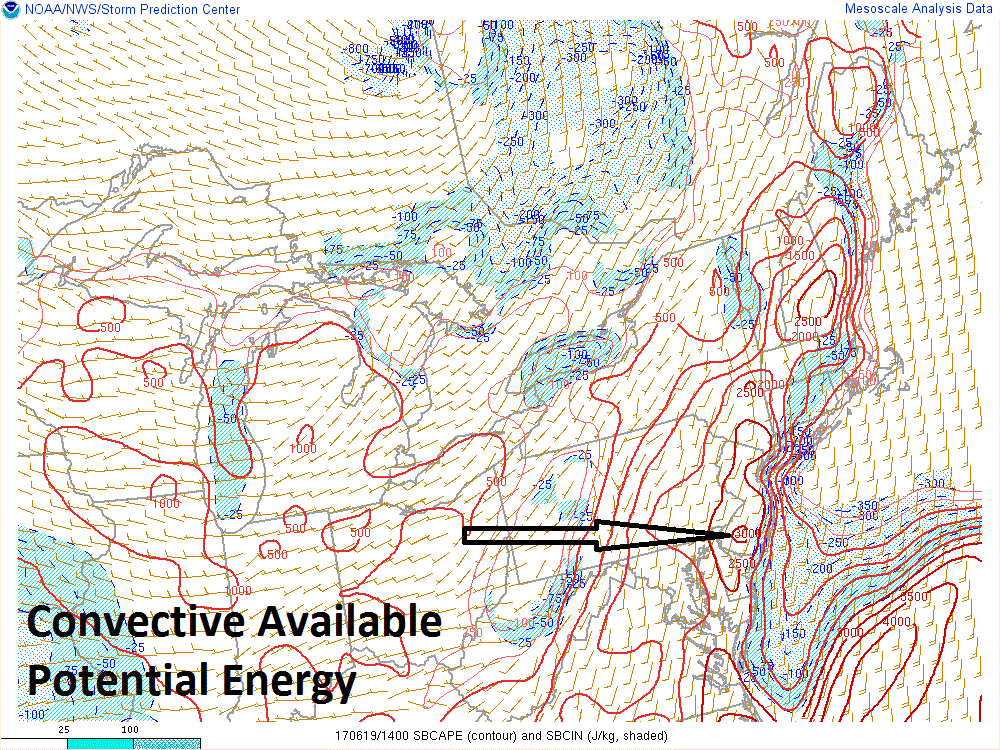
Latest analysis of Convective Available Potential Energy (CAPE) indicates high instability over the I-95 corridor; courtesy NOAA/SPC
Overview
A potent cold front is headed towards the I-95 corridor and it may help to generate severe thunderstorms in DC, Philly and New York City from late today into tonight. Heavy rainfall is likely at times during this event and flash flooding is a concern for the entire region. Any thunderstorm can produce damaging wind gusts, downpours, hail, intense lightning and even possible isolated tornado activity. The most likely timetable for these potential powerful storms is 3pm -9pm.
Severe storm discussion for the Mid-Atlantic
Ingredients are falling into place for strong-to-severe thunderstorms from late today into tonight in the I-95 corridor which can include flash flooding, damaging wind gusts of up to 65 mph, hail, intense lightning and even possible isolated tornadoes. At the surface, there is a strong cold front moving slowly eastward towards the eastern seaboard. In the upper atmosphere, there is a strong upper-level wave of energy crossing the Great Lakes which will pivot across the Mid-Atlantic by early tonight. The atmosphere is already quite unstable as indicated by the Convective Available Potential Energy (CAPE) which is highest (i.e., most unstable) right near the I-95 corridor region of Philly and SW New Jersey.
Latest analysis of Precipitable Water indicates high moisture content over the I-95 corridor; courtesy NOAA/SPC
In addition, there is plenty of available moisture as indicated by the latest map of precipitable water which shows a peak value (i.e., most moist) right over southeastern Pennsylvania. Once the upper-level energy pivots across the area later today/early tonight, it will provide some serious lifting action in the atmosphere, and the effect will be to “squeeze out” a lot of available moisture in the form of tropical-like downpours. Latest satellite images continue to show some breaks in the clouds in advance of the cold front and this will also allow for further destabilization of the atmosphere as surface temperatures climb towards the 90 degree mark.
Once the activity dies down late tonight, the I-95 corridor may actually set up for a decent stretch of weather on Tuesday, Wednesday and Thursday. It’ll likely become unsettled again at the end of the week and into the upcoming weekend.
Tropical Update
There is increasing likelihood for heavy rain over the next few days extending from the Florida Panhandle to Texas as a tropical storm forms over the Gulf of Mexico. A broad area of low pressure extends today from the Yucatan Peninsula across adjacent portions of the southeastern Gulf of Mexico and it is generating a large area of disorganized showers and thunderstorms along with winds to gale force several hundred miles east and northeast of the estimated center. While the low still lacks a well-defined center of circulation, gradual development is expected today through Tuesday while it moves across the southern and central Gulf of Mexico, and a tropical or subtropical cyclone is likely to form. Later in the week, this system is likely to slide in the western Gulf of Mexico region and another tropical storm may form over the western Atlantic Ocean or Caribbean Sea.
Meteorologist Paul Dorian
Vencore, Inc.
vencoreweather.com
Mid-day extended video discussion:


