12:30 PM | **Wild weather next several days with everything from the 60’s to Arctic cold…heavy rain, thunderstorms, fog to possible ice and accumulating snow**
Paul Dorian

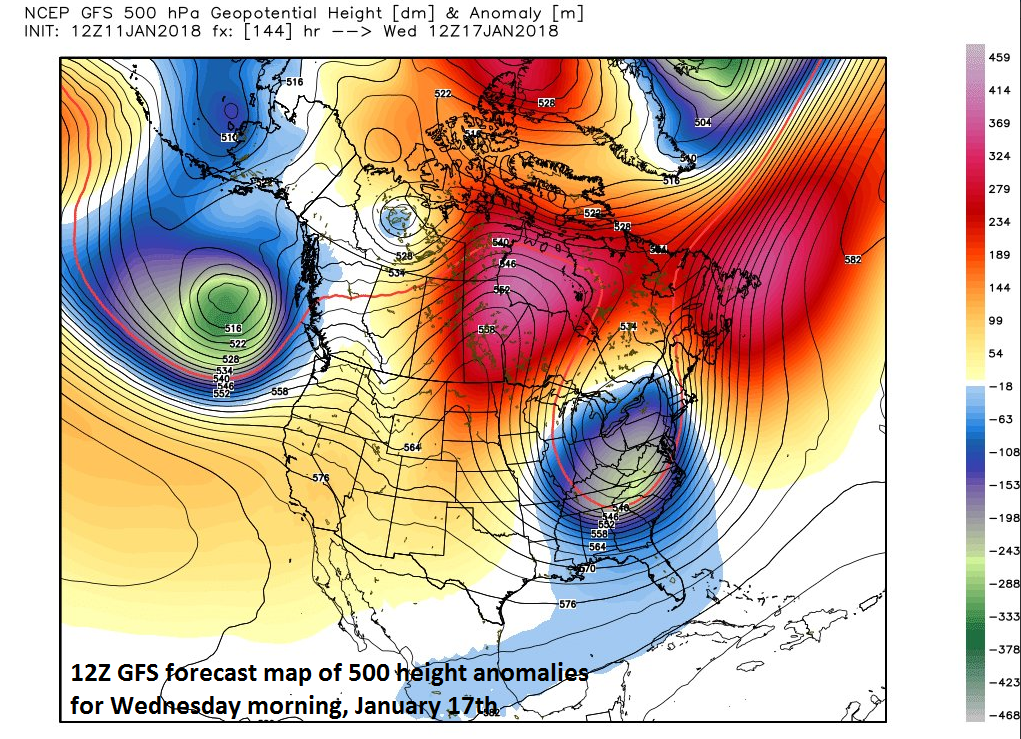
12Z GFS forecast map of 500 mb height anomalies on Wednesday, January 17th featuring an impressive upper-level trough over the Mid-Atlantic region with high pressure ridging west of Hudson Bay; map courtesy NOAA/EMC, Weather Bell Analytics (Joe Bastardi)
Overview
The overall weather pattern from tonight through the middle of next week will be quite volatile with wild swings in temperatures from the 60’s on Friday afternoon to Arctic cold for this weekend and much of next week. This late week "January thaw" will also result in heavy rain for the I-95 corridor and thunderstorms could even get mixed into the picture as well as some patchy fog. As Arctic cold arrives in the big cities on Saturday morning, the precipitation could mix with or change to ice and/or snow before ending by mid-day. Then, after a couple of dry and quite cold days, accumulating snow may threaten the I-95 corridor from later Tuesday into Wednesday as a reinforcing Arctic blast arrives in the eastern US.

12Z GFS forecast map for Saturday morning, January 13th. Lots of colors on this map means lots of potential problems...rain (green), sleet/freezing rain (purple, pink), snow (blue); map courtesy NOAA/EMC, tropicaltidbits.com
Thursday night-Saturday (wild swing in temperatures…heavy rain, thunderstorms-to-ice, snow threat)
This relatively brief "January thaw" that began on Wednesday in the I-95 corridor will peak tomorrow afternoon with temperatures likely reaching the 60’s from DC-to-Philly-to-NYC. There will be other "January thaw" time periods in the Mid-Atlantic region later this month - perhaps even more dramatic than the current one. An Arctic cold front will be heading in our direction from the Ohio Valley on Friday and its arrival here early in the weekend will bring a dramatic end to the late week mild spell. A strong storm will form along the frontal boundary zone on Friday and will move just to the northwest of the big cities by later tomorrow night.
Soaking rain is coming to the Mid-Atlantic region as part of this warm up and transition to Arctic cold and it looks like the heaviest of the rain will be concentrated in two different time periods: 1) late tonight into early Friday and then 2) later tomorrow night into early Saturday. In each of these two time periods, there can be some heavy rain at times and a thunderstorm or two can mix into the picture. Also, patchy fog is possible at just about any time from tonight through tomorrow night given the cold ground and the milder air moving into the lower part of the atmosphere.
As the Arctic cold advances to the southeast in the Ohio Valley on Friday, rain will change to ice and then to accumulating snow and some areas could receive significant accumulations of snow and ice. In fact, this type of pattern may result in a “flash freeze” across portions of the Ohio Valley as temperatures are likely to drop very quickly from above-to-below freezing and roadways become treacherous in a hurry. The transition to Arctic cold may not be quite as dramatic here on Saturday, but there is a concern that the rain mixes with or changes to sleet and/or snow before ending on Saturday morning. Temperatures here will also tumble from relatively mild levels tomorrow night to near freezing by later in the day on Saturday (expect cold, windy conditions for the late afternoon Eagles playoff game).

12Z GFS forecast map for Tuesday afternoon, January 16th with snow in blue; map courtesy NOAA/EMC, tropicaltidbits.com
Tuesday/Wednesday (accumulating snow threat)
After a couple of dry and cold days on Sunday and Monday, upper-level energy from the Northern Plains will be dropping southeastward across the Ohio Valley by Tuesday. As has been the case for much of this winter, the northern branch of the jet stream has dominated the scene in this “La Nina” winter, and this is a case in which a wave of upper-level energy will “dig” to the southeast from the northern Plains and ultimately produce problems for the Mid-Atlantic/Northeast US. In this particular scenario, low pressure is likely to form somewhere near the Mid-Atlantic coastline later Tuesday into Wednesday as a reinforcing Arctic air mass pushes towards the region along with the wave of upper-level energy. The result could very well be accumulating snow for the DC-to-Philly-to-NYC corridor from later Tuesday into Wednesday – stay tuned.
Meteorologist Paul Dorian
Vencore, Inc.
vencoreweather.com
Today’s video discussion on the wild weather pattern for the next several days: