2:15 PM | ***Wild weather continues: 50 degree drop in temperatures…more heavy rain possible thunderstorms…ice threat tomorrow morning…mid-week snow threat***
Paul Dorian

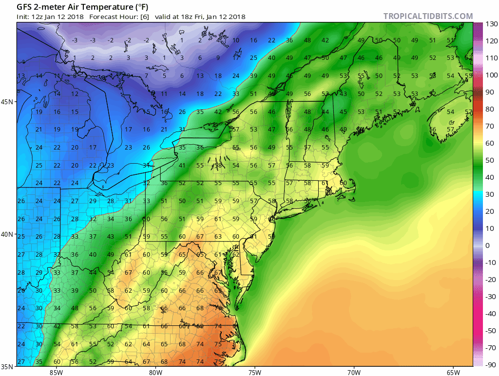
12Z GFS forecast of surface air temperatures between this afternoon and early Sunday (6-hour increments); maps courtesy NOAA/EMC, tropicatidbits.com
Overview
A very active weather pattern has begun and will continue for the next several days. Heavy rain has already fallen today on much of the I-95 corridor and another round will take place later tonight into early Saturday. An Arctic front will pass through the region by early tomorrow and this will result in about a 50 degree temperature drop between now and early Sunday morning in the I-95 corridor as Arctic air floods the area following the warm conditions of today. The rain could end as a period of sleet and/or freezing rain tomorrow morning as the Arctic air arrives; especially, to the north and west of the big cities. Then, after a couple of dry and cold days, snow may threaten the I-95 corridor from later Tuesday into Thursday as low pressure tries to form near the Mid-Atlantic coastline.

Latest radar map with "boxed in" region indicating where our second round of heavy rain is coming from; map courtesy College of DuPage, NOAA
Today/Tonight/Saturday
An Arctic cold front is heading in our direction from the Ohio Valley and its arrival early tomorrow will bring a dramatic end to our current relatively short-lived warm spell. A strong storm is forming along this advancing frontal boundary zone and it will move in a northeasterly direction very close to the DC-to-Philly-to-NYC corridor in the late night hours. Heavy rain has already plagued much of the I-95 corridor today; especially, along the Delaware River region from Philly northward into New York. There will be a break in the action this afternoon and early evening with nothing more than scattered showers, but then another round of steadier and heavy rain with possible thunderstorms is coming for later tonight into early Saturday as the strong low pressure system moves nearby.
As the Arctic cold advances to the southeast early tomorrow, rain will likely change briefly to a period of sleet and/or freezing rain; especially, to the north and west of the big cities. Roadways can become slippery in some spots and any remaining water left behind on untreated surfaces from today’s storm is likely to freeze by later in the day. Temperatures could very well drop from the 50’s late tonight to the 30’s in only about a 3-hour period following the passage of the Arctic front and temperatures will then likely hold steady or slowly fall though the rest of the day. The late afternoon Eagles playoff game will feature dry, quite cold and windy conditions with temperatures dropping into the 20’s.
Late Tuesday into Thursday threat of snow
An upper-level trough will intensify in the eastern US by the middle of next week and low pressure is likely to form somewhere near the Mid-Atlantic coastline as another Arctic air mass arrives. If this orientation of the upper-level feature takes on a “negative” tilt (i.e., axis extends from northwest-to-southeast) tilt then a strong storm would likely form in time to produce accumulating snow for the DC-to-Philly-to-NYC corridor. If, however, this upper-level feature stays “neutral” or “positive” in its orientation then low pressure could form too far to our south and east to greatly impact the DC, Philly and NYC metro regions. It is a bit too early to tell with any kind of certainty, but the potential is there for accumulating snow during the mid-week time frame. It will be cold enough during this time period for snow, however, another noticeable warm up is likely during the following Friday/Saturday/Sunday time period.
Meteorologist Paul Dorian
Vencore, Inc.
vencoreweather.com