12:00 PM | ****The worst that winter has to offer next few days…snow, extreme cold and dangerous sub-zero wind chills****
Paul Dorian

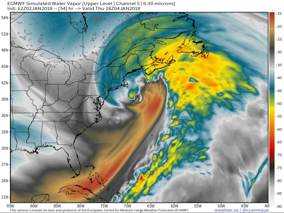
Simulated water vapor image for Thursday afternoon using GOES-16 and Euro computer forecast model data featuring a powerful storm off of New England with hurricane-like winds and strength; map courtesy Dr. Ryan Maue (weather.us), NOAA, ECMWF
Overview
The bitter cold weather pattern of the past couple of weeks for the eastern two-thirds of the nation will not ease up at all this week and an added feature will be a powerful storm that develops over the western Atlantic Ocean. This storm is likely to generate ice and accumulating snow from Florida to New England over the next couple of days and accumulating snow can fall all the way back to the immediate I-95 corridor region between DC and Philly. Temperatures today will stay below freezing across about 80% of the nation and record lows have been set this morning in dozens of locations repeating a similar performance of yesterday morning. Perhaps even more important than any snow that falls from this upcoming storm will be the extreme cold that follows in the eastern US during the Thursday night to Saturday time period. Wind chills will reach dangerous sub-zero levels as winds gust to 50 mph or so in this late week time period and power outages are a concern. A relaxation in temperatures is likely to arrive in the Mid-Atlantic region by early next week, but there may be a wintry mix of rain, sleet and/or snow to accompany that “warm up”.

12Z NAM forecast map at 500 mb for Thursday morning with "phasing" together of upper-level energy just off the Mid-Atlantic coastline. Any quicker "phasing" of these systems could shift the significant snow axis to the west for the upcoming storm system. Map courtesy NOAA/EMC, tropicaltidbits.com
The powerful Atlantic Ocean storm
A storm will form off of the east coast of Florida on Wednesday and it’ll become a monster by the time it reaches the area east of Maine on Thursday night. This storm will intensify rapidly as upper-level energy “phases” together near the east coast and a trough aloft goes "negatively-tilted" (i.e., trough axis oriented NW-to-SE) which will generate strong upward motion at the surface. Central pressure for this storm could actually drop to 28.14 inches by Thursday night according to the latest (12Z NAM) computer forecast model as it treks to the east of Maine and this rapid and deep strengthening will result in a very strong pressure gradient that will produce powerful winds - indeed, power outages are of concern for later in the week.

12Z NAM forecast maps for Thursday morning (left) and Thursday evening (right) featuring a rapidly intensifying low pressure system over the western Atlantic Ocean; maps courtesy NOAA/EMC, tropicaltidbits.com
Rather typical for rapidly intensifying ocean storms, there is likely to be a sharp drop off to precipitation amounts on its western edge. This sharp drop off in total precipitation amounts may very well setup in the zone between the east coast and Route 95 so that snowfall amounts could be limited to a dusting to 3 inches in DC and Philly, but significantly higher amounts can fall in the NYC metro region (3-6 inches) with 6+ inches from "Long Island to coastal New Jersey to the coastal sections of the Delmarva Peninsula". Southern New England is likely to get pummeled by this unfolding western Atlantic storm with significant snow and wind; especially, along coastal sections where a foot or more can accumulate. Any slight shift to the west in the currently expected storm track can increase snow amounts significantly in the DC-to-Philly corridor - and this is still within the realm of possibility.

Record or near record lows on the last two mornings (January 1, left; January 2, right) which extend from the Rockies to the east coast to the Gulf of Mexico; maps courtesy coolwx.com
The extreme Arctic cold
This three week period from around December 20th, 2017 to January 10th, 2018 will be one of the coldest stretches in a long, long time for a good part of the country and we'll look back at it in amazement when all is said and done. Just this morning temperatures dropped to 30 degrees in Pensacola, Florida and stretched to 110 hours with below zero conditions in Fargo, North Dakota. In addition, the ice coverage on the Great Lakes has increased by a substantial 16% in just the last 10 days.
In many ways, the extreme cold and dangerous wind chills that follow the upcoming storm may end up being more impactful than any snow that falls. Numerous low temperature records have been set today throughout the eastern two-thirds of the nation and this repeats the performance of yesterday morning. This roughly three week period from around December 20th to January 10th will be one of the coldest stretches in a long, long time for a good part of the country. In just the last 10 days, the ice coverage on the Great lakes has increased by 16$. The current cold wave is especially impressive given its extent in time (2-3 weeks) and space (Rockies to the east coast to the Gulf coast) and it is somewhat reminiscent of January 1977 which was well below-normal in the same general vicinity. In fact, many of the record lows that were set during the past couple of days broke records that were originally set in January of 1977.

January 1977 was a very cold month across the eastern two-thirds of the nation. There are many similarities to this current extended cold wave including the same areal extent as before and many of the records broken during the past two mornings were originally set in this particular month. Data courtesy NOAA
Temperatures on Wednesday ahead of the storm will actually make a run towards the 30 degree mark, but that should be the high point of the week. Single digits lows are quite likely again on Friday and Saturday mornings and highs will do no better than the low-to-mid teens in many spots on both days. Wind chill values are likely to drop well below zero in the period from Thursday night into Saturday as gusts to 50 mph are possible following the departure of the powerful Atlantic Ocean storm.
One final note, only 43 days until pitchers and catchers report to spring training.

According to NOAA, "low" temperature records have outpaced "high" temperature records across the US during the last 30 days.
Meteorologist Paul Dorian
Vencore, Inc.
vencoreweather.com
Extended video discussion on the upcoming Atlantic Ocean storm and extreme cold to follow: