11:50 AM | *****High impact weather event continues…soon to shift from accumulating snow phase to extreme cold phase with powerful winds and dangerous sub-zero wind chills*****
Paul Dorian

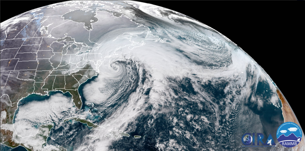
Mid-day look at the powerful western Atlantic storm.
Overview
A high impact weather event continues for much of the eastern US with bands of accumulating snow soon to be followed by extreme cold and dangerous sub-zero wind chills. This storm now ranks as one of the most intense east coast winter storms ever in terms of how fast and how much it has intensified while moving over the relatively warm waters of the western Atlantic Ocean (i.e., Gulf Stream). In fact, the central pressure dropped 54 millibars in a 24-hour period reaching major hurricane-like strength (category 3) by 7AM of 954 millibars (28.17) and it is unleashing hurricane-force winds along coastal sections of New Jersey to New England. Heavy snow bands rotating around the storm will continue for the few hours in the Mid-Atlantic region, but by later today, the powerful winds will become the main factor and then the extreme cold.

Mid-day look at the barometric pressure field associated with the powerful western Atlantic storm.
Details
This powerful ocean storm continues to intensify in the mid-day hours as it pushes north from off of the Mid-Atlantic coastline. Winds have shifted to a NW direction in most many areas from DC-to-Philly-to South Jersey which is indicative of an ocean storm beginning to pull away from the local region. Snow bands will continue to pinwheel around this powerful storm for another couple hours and any band can add quick additional accumulations to roadways and other surfaces. General snowfall totals in the DC-to-Philly-to-NYC corridor will range from about half an inch far west in the DC metro region to 3 inches in its far eastern areas, 2 or 3 inches far west in the Philly metro region to 6 inches or so in its far eastern sections, and anywhere from 6-12 inches likely in the NYC metro region where "whiteout" conditions are possible next couple hours as a heavy snow band moves overhead. Coastal sections of New Jersey can end up with as much as 12-18 inches in spots and winds will gust past 50 mph (i.e., blizzard conditions) this afternoon and evening. Even as the snow winds down, roadways will likely continue to be problematic since blowing snow will continue and re-cover many areas that have previously been cleared. Winds will gust past 40 mph through the afternoon and night at inland locations along the I-95 corridor and past 60 mph along coastal sections. Scattered power outages are, of course, a real concern from tonight into Saturday given the extreme cold that is on the way.

Mid-day colorized water vapor imagery look at the powerful western Atlantic storm.
The period from tonight through Saturday night will be an outrageously cold time period to go along with powerful winds that will produce dangerous sub-zero wind chills. Temperatures will drop sharply overnight with lows in many spots by early tomorrow in the lower-to-middle single digits. Overnight low temperatures both tomorrow night and Saturday night could bottom out near zero degrees to go along with those strong winds and dangerous sub-zero wind chills.

3 PM forecast map from high-resolution model (HRRR) with snow winding down in DC-to-Philly corridor.
Be prepared for this unfolding high impact weather event and check this NOAA web site for information on winter safety tips.
Meteorologist Paul Dorian
Vencore, Inc.
vencoreweather.com