2:00 PM **A weekend full of record-breaking cold**
Paul Dorian

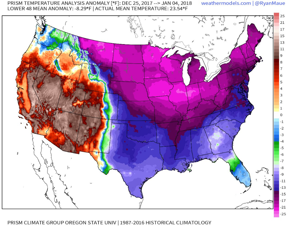
Nationwide temperature anomalies averaged for the ten-day period between Decmber 28th and January 4th; courtesy Dr. Ryan Maue at weathermodels.com, Prism Climate Group, Oregon State University
Overview
The stretch of weather that began just before Christmas Day has been very cold relative-to-normal for much of the eastern two-thirds of the country and it may reach a nadir this weekend. Temperatures during the next couple of mornings in the DC-to-Philly-to-NYC corridor should rather easily drop to single digits and some spots will likely reach zero or even sub-zero conditions. Each morning this week has featured numerous record-low temperatures in the Northeast US, Midwest and Mid-Atlantic regions and that pattern should continue tomorrow morning and perhaps become even more widespread early Sunday morning. It’ll stay very cold on Sunday, but less painful than Saturday as temperatures will climb a bit and winds will drop off in intensity and then there will be more modification on Monday with many areas attempting to climb above freezing for the first time in many days. More significant warming in the I-95 corridor is likely late next week for a few days and then an even greater and more widespread “January thaw” is possible later this month.
Intense and potential record-breaking cold
Over the just-ended ten day period from December 25th-January 4th, daily temperatures east of the Rockies averaged anywhere from 10°F to 25°F below-normal centered on the Northern Plains, Midwest, Great Lakes and New England. Furthermore, preliminary numbers suggest that the week-long period centered on New Year’s Eve (i.e., December 28th-January 3rd) may turn out to be one of the top five coldest in a large swath of the country from the Great Lakes to the Northeast US for that particular week of the year. The lowest US temperature recorded during this ten-day cold stretch was minus 45 degrees in two places: Embarrass, Minnesota (Sunday morning) and Hettinger, North Dakota (Monday morning). The lowest wind chill value during the ten-day cold stretch was minus 58 degrees on Sunday morning in Hettinger, North Dakota.
This widespread cold wave that has been ongoing in the eastern half of the nation since just before Christmas Day is likely to result in numerous daily cold temperature records this weekend across the Great Lakes, Mid-Atlantic and Northeast US (both record lows and record-cold highs). The most widespread time for record-breaking low temperatures may very well turn out to be early Sunday morning in this region as the combination of fresh snow cover and diminishing winds could produce perfect conditions for temperatures to plunge in the overnight hours.
Some of the records that are in jeopardy this weekend in the DC-to-Philly-to-NYC corridor are as follows:
- Saturday, January 6th: New York City-Manhattan (+6 degrees), Philly (+4 degrees), DCA (+2 degrees), BWI (+5 degrees), IAD (+4 degrees)
- Sunday, January 7th: New York City-Manhattan (+3 degrees), Philly (+4 degrees), DCA (+5 degrees), BWI (+3 degrees), IAD (+1 degree)
Other notes of interest (courtesy"weather.com"):
- if Philly and New York City slip below zero on Sunday morning, it would be the first time in Philly since 1994 and the second time in New York City since 1994 (last time below zero in NYC was in 2016).
- New York City has not seen an above freezing high temperature since Christmas Day and this should end up as one of the top five longest stretches for the most number of days in a row at 32 degrees or below.
-Chicago will tie a record on Saturday for most consecutive days (12) below 20 degrees for highs (set twice before in 1936 and 1895).

Long-range forecast map of 850 mb temperature anomalies by the 12Z GEFS averaged over the 5-day period of January 16-January 21 (i.e., days 12-16); courtesy NOAA/EMC, tropicaltidbits.com
January Thaw
Looking past this weekend, there is some good news in the temperature department. Temperatures should climb quite a bit late next week in the Mid-Atlantic region during the Thursday-Saturday time period (i.e., January 11-13) and it could be accompanied by some rain. Furthermore, a more substantial and widespread January thaw is possible later this month with signs pointing to this potential warm up occurring for much of the nation. A second bit of good news…pitchers and catchers report to spring training in just 38 days. One word of caution, any kind of thaw that takes place after this kind of a cold wave is liable to result in the explosion of potholes.
Meteorologist Paul Dorian
Vencore, Inc.
vencoreweather.com
Today’s video discussion on the “weekend full of record-breaking cold”: