
1:10 PM | *All systems go for a strong storm in the Mid-Atlantic region*
Paul Dorian
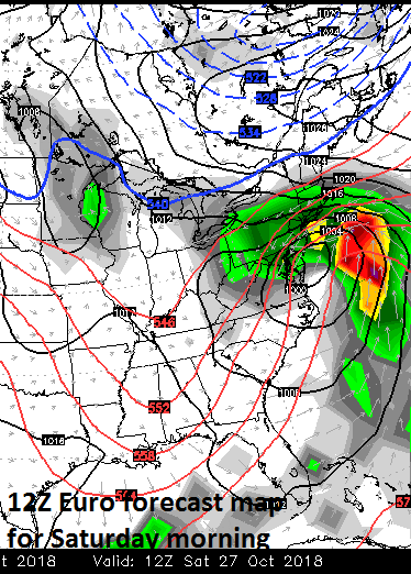
Low pressure near the Mid-Atlantic coastline on Saturday morning, October 27th according to the 12Z Euro; courtesy ECMWF, WSI, Inc.
Overview
The ingredients are going to fall into place for a strong storm in the Mid-Atlantic region that is likely to bring rain and wind to the I-95 corridor and points east to the coast from later Friday into late Saturday. The combination of copious amounts of low-level moisture, deep and broad upper-level energy, and an unfolding blocking pattern aloft is likely to result in strong low pressure near or along the east coast that will become a rather slow mover. Interestingly, some of the moisture that gets intertwined into this system will come from Hurricane Willa which has weakened very significantly in the past 24 hours (rise of 45 millibars in its central pressure) and is now a category 3 storm just off the west coast of Mexico. This tropical system will continue to weaken as it moves northeastward over the next couple of days; however, it will add some moisture and energy to low pressure that will develop over the Gulf of Mexico later in the week.

Very deep and large low pressure trough will form in the eastern US this weekend; courtesy NOAA/EMC, tropicaltidbits.com
Discussion
Colder air will push into the Northeast US later tonight following the passage of a cold frontal system and this chilly air mass will stick around into the latter part of the work week. At that point in time, a ton of moisture from the Gulf of Mexico will begin to push northeastward as a deep upper-level trough of low pressure forms in the eastern US. As the upper-level trough becomes negatively-tilted, strong upward motion will develop along the Mid-Atlantic coastline and low pressure is likely to intensify near coastal North Carolina by Friday night. As a result of “blocking” that develops by the weekend over eastern Canada, this storm will become somewhat of a slow-mover and only travel from coastal North Carolina to near New York City by Saturday night.

Hurricane Willa will continue to weaken as it moves to the northeast over the next couple of days; map courtesy NOAA/NHC
Clouds will thicken up early on Friday in the DC-to-Philly-to-NYC corridor and rain should begin later in the day and continue right through Saturday. Given the “blocking” pattern setting up aloft, the threat for rain may return by late Sunday and continue into Monday as a second piece of energy rotates through the deep upper-level trough in the eastern US. Colder air will seep into the overall pattern later in the weekend and the result could be some frozen precipitation in the interior higher elevation sections of the Northeast US by Sunday night or Monday.
Meteorologist Paul Dorian
Perspecta, Inc.
perspectaweather.com