11:15 AM | **Hurricane Michael likely to strike Florida Panhandle on Wednesday as a “major”**
Paul Dorian

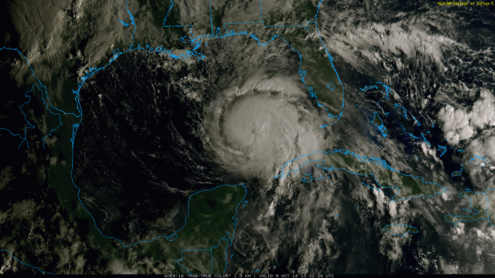
The latest “true color” satellite imagery loop of Hurricane Michael; courtesy NOAA/GOES-16, College of DuPage
Overview
Hurricane Michael continues to intensify as it moves over the very warm waters of the Gulf of Mexico (now a cat 2) and an eye is becoming more visible on satellite imagery. There is a high probability that Michael will reach major hurricane status (i.e., cat 3 or higher) before a landfall on Wednesday in the Florida Panhandle - perhaps between Destin and Apalachicola – as wind shear in its general vicinity continues to decrease. Once landfall is reached, Hurricane Michael will turn from a northerly direction to a northeasterly track and ride up along the Southeast US coastline and heavy rain and strong winds are likely in the already rain-soaked region of the Carolinas where Hurricane Florence stalled out last month. While it appears the DC-to-PHL-to-NYC corridor will not get a direct hit from the remains of Michael, there will be rain here on Thursday as the tropical system interacts with a strong cold front and some of the rain can be heavy at times. Quite cool and dry weather should follow in the Mid-Atlantic region for Friday, Saturday and Sunday.

The latest storm track of Hurricane Michael as predicted by NOAA’s National Hurricane Center where H=Hurricane, M=Major and S=Tropical Storm.
Details
At 11 am, Hurricane Michael is categorized as a “2” storm with max sustained winds now at 110 mph and a central pressure of 28.50 inches. The present movement is to the north at 12 mph. Hurricane Michael is a dangerous storm for the Florida Panhandle especially since it will be intensifying in the hours before landfall with storm surge a primary danger and wind damage also a significant threat. In fact, there is a strong likelihood that Michael will reach “major” hurricane status later today and then make landfall later tomorrow in the Florida Panhandle still as a “major” - perhaps even as a cat 4. Latest satellite imagery shows a symmetrical appearance to the hurricane indicative of intensification in recent hours as it crosses over very warm Gulf of Mexico waters.

Very warm waters in the Gulf of Mexico are helping to fuel the intensification of Hurricane Michael; courtesy NOAA, tropicaltidbits.com
Additional intensification is likely over the next 12-24 hours as (westerly) wind shear will diminish in its general vicinity and upper-level ridging builds overhead. Once Michael reaches the Florida Panhandle on Wednesday, it will become increasingly influenced by an upper-level trough of low pressure moving into the central US. As a result, its direction will change from north to northeast and this will allow for it to push along the Southeast US coastline from Wednesday night into Thursday. A cold frontal system will be closing in on the east coast on Thursday and it will interact with the moisture of Michael resulting in some rains in the DC-to-PHL-to-NYC corridor, perhaps heavy at times. A more direct hit by the remnants of Hurricane Michael is likely on Thursday across SE VA, the southern part of the Delmarva Peninsula, and perhaps in the extreme southern part of NJ. Following the passage of Michael and the cold frontal system, quite cool and dry weather will move into the Mid-Atlantic for Friday, Saturday and Sunday.
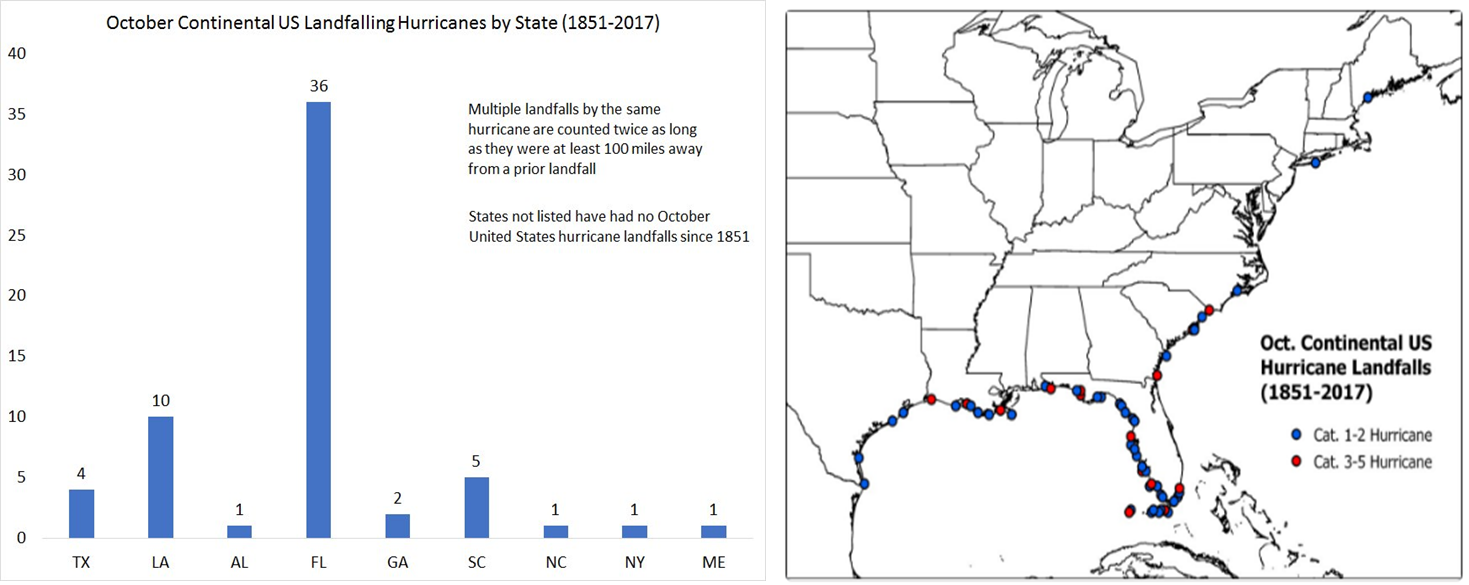
October landfalling hurricanes are not unusual for the state of Florida; info courtesy Dr. Philip Klotzbach (Colorado State University)
Florida hurricane history
Landfalling hurricanes in the state of Florida during October are not all that unusual. In fact, about 60% of all October continental US hurricanes have made landfall in Florida in the period 1851-2017. Hurricane Opal was the most recent October landfalling hurricane in the Florida Panhandle in 1995. Opal was a large and powerful category 4 hurricane that caused extensive damage along the northern Gulf Coast. It crossed the Yucatan Peninsula while still a tropical depression on September 27, 1995, then strengthened and moved northward in the Gulf before making a second landfall on October 4 in the Florida Panhandle near Pensacola as a 115-mph category 3 hurricane.
The most recent hurricane to hit the region was Hermine in September 2016 (as a category 1 storm). That system actually broke an unprecedented 10-year landfall drought in Florida which had extended back to October 2005 (Hurricane Wilma). The last major hurricane to make landfall the Florida Panhandle/Big Bend region was Hurricane Dennis in July 2005 (category 3). In fact, there have been three major hurricanes in the Florida Panhandle since 1950 (Eloise 1975, Opal 1995, Dennis 2005). In terms of November hurricanes, one notable storm was Hurricane Kate in 1985 which achieved major category 3 status before coming ashore in Mexico Beach, Florida as a slightly weakened category 2 system.
Meteorologist Paul Dorian
Perspecta, Inc.
perspectaweather.com
Today’s video discussion on Hurricane Michael: