
12:30 PM | **Major storm threat later next week/weekend from California to the east coast**
Paul Dorian
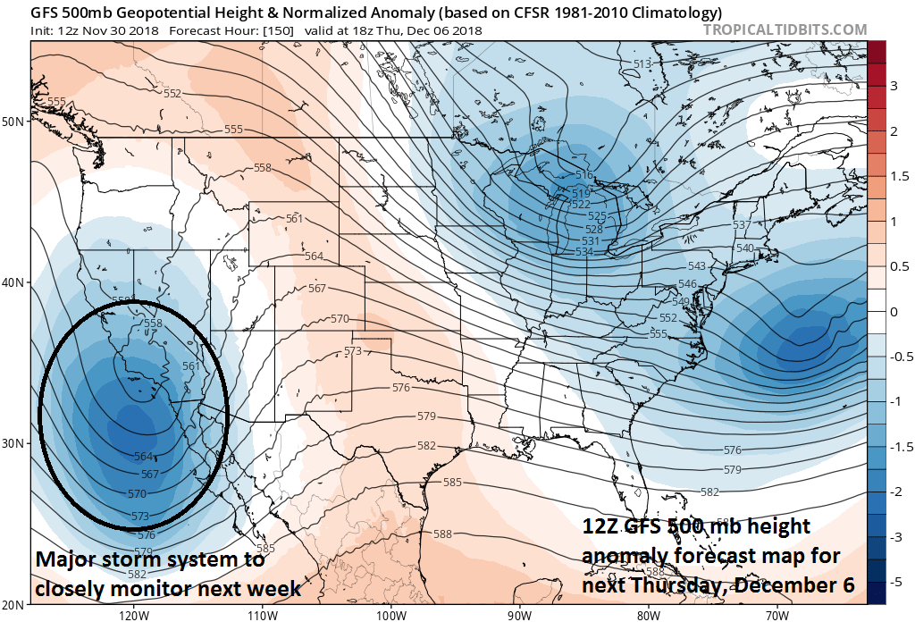
12Z GFS 500 mb height anomaly forecast map for next Thursday, December 6 with a deep upper-level just off the southwest coast of California; courtesy NOAA/EMC, tropicaltidbits.com
Overview
The cold and stormy pattern that brought widespread colder-than-normal conditions to much of the country in November as well as some significant early season snowfall looks like it will continue during the first couple weeks of December. One storm will pound the central Plains this weekend with significant accumulating snow and rain will once again dampen conditions in the Mid-Atlantic region. After that, there is likely to be a strong storm system over the eastern Pacific Ocean around the middle of next week riding along in the southern branch of the jet stream. This storm may hit California in the Wednesday/Thursday time frame with coastal rains and inland snows and it could take a southern track across the US and very well end up near the Mid-Atlantic coastline sometime next weekend as a significant snow and rain producer.

“Top ten coldest November” ever in many spots of the eastern and central US (Blue boxes = top 10, purple boxes = top 5); courtesy NOAA/SRCC
Details
The month of November winds down today and it has been colder-than-normal across a very large portion of the US and the widespread cold has actually extended from Mexico-to-Canada. In fact, numerous spots in the eastern half of the US are experiencing one of the top ten coldest Novembers in recorded history and the overall cold trend will continue in this same area during the first couple weeks of December. Looking ahead to next week, the 5-day period from December 2nd – December 7th is likely to average out with more widespread colder-than-normal conditions virtually extending from coast-to-coast. This colder-than-normal weather pattern will likely then continue across the eastern part of the nation in the following 5-day period from December 7th – December 12th while the western US returns to normal or slightly above normal temperatures.

2-meter temperature anomalies for the month of November with colder-than-normal conditions (blue, green) extending from Mexico-to-Canada; map courtesy Weather Bell Analytics at weatherbell.com, NOAA
In addition to the cold, November was quite stormy as well with much of the nation experiencing significant early season snowfall including the Plains, Midwest, Mid-Atlantic and Northeast. In terms of upcoming storminess, one storm will impact a large part of the nation this weekend with primarily rain in the east and accumulating snow from the central Plains to the Upper Midwest. In fact, a foot or more of snow can fall over the next few days in places like South Dakota and Nebraska. Looking ahead, another storm system is likely move over the eastern Pacific Ocean and head towards the central and southern parts of California around the middle of next week. After potentially hitting California in the Wednesday/Thursday time frame, this storm may then take the “southern route” and cross over the south-central states and then into the Southeast US by late next week or early in the following weekend. In fact, this storm very well could be sitting right near the Mid-Atlantic coastline sometime next weekend (December 8/9 time frame). There is potential that enough cold air will be around in the Mid-Atlantic region and Northeast US at the arrival time for this storm to result in accumulating snow…stay tuned on this as it will become clearer over the next few days.

850 mb temperature anomalies for days 3-7 (left, December 2 - December 7) and days 8-12 (right, December 7 - December 12); courtesy NOAA/EMC, tropicaltidbits.com
Looking farther ahead, the warm up that begins in the western US during the second week of December could very well push to the eastern US by the middle of the month and it could stick around for awhile - maybe even to Christmas.
Meteorologist Paul Dorian
Perspecta, Inc.
perspectaweather.com
Video discussion: