
2:15 PM | *Three systems to monitor next 5 days…nuisance snow tomorrow well north of PA/MD border…soaking rain event later Friday/Saturday…strong winds with next cold shot…an early peek at Christmas*
Paul Dorian
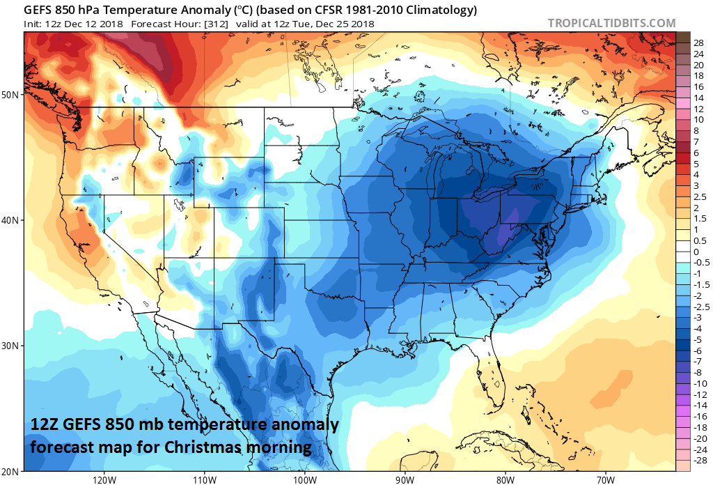
Long-range look at the 850 mb temperature anomalies for Christmas Day and the 12Z GEFS features quite cold air in the eastern half of the nation; courtesy NOAA/EMC, tropicaltidbits.com
Overview
There has been a bit of a lull this week in the recent active weather pattern, but that will change in coming days and there are three different systems that bear watching between today and early next week. The first system is likely to produce some nuisance snow in areas primarily well to the north of the Mason-Dixon Line from late tonight into mid-day tomorrow and there can be some slippery road conditions. The second and stronger system will generate a soaking rain event in the DC-to-Philly-to-NYC corridor from late Friday into Saturday morning and the rain can linger in late Saturday and even into Sunday as it’ll be a slow mover. On the heels of the weekend storm, another cold shot will arrive on Monday and it will be supported by vigorous energy in the upper atmosphere which could result in strong winds in the Northeast US and numerous snow showers.
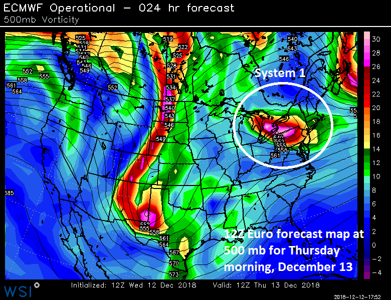
12Z Euro forecast map for Thursday morning with a strong wave of energy over the eastern Great Lakes/Northeast US; courtesy ECMWF, WSI, Inc.
System 1 (Late tonight/tomorrow)
The first three days of the work week have been rather quiet in the Northeast US/Mid-Atlantic with plenty of sunshine and overall good drying conditions. Temperatures have been persistently below-normal, however, continuing a trend that started in November for the Mid-Atlantic and much of the eastern US. One strong wave of energy in the upper atmosphere will slide across the Great Lakes and into the northern Mid-Atlantic region early Thursday likely producing an area of snow; primarily, in areas well to north of the PA/MD border. This type of system has limited moisture available to it; however, it can still generate a coating to an inch of snow across much of upstate Pennsylvania, New Jersey, and southern New York with a couple inches possible in higher elevation locations such as the Poconos. The timing of the snow is rather problematic as there can be some snow just in time for the AM commute on Thursday and the ground is quite cold due to the recent persistent cold so watch out for potential slippery spots.
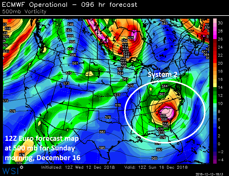
12Z Euro forecast map for Sunday morning with a strong wave of energy over the Southeast US; courtesy ECMWF, WSI, Inc.
System 2 (Friday, Saturday, Sunday)
On Friday, it’ll turn milder as the next system of interest takes shape in the south-central states and this will become quite complex. Surface low pressure will push towards the Tennessee Valley by late Friday supported by vigorous energy aloft and a secondary low pressure system is likely to form near the east coast by the early weekend. The combination of the two surface systems and strong energy aloft should result in a soaking rain from late Friday into Saturday in the DC-to-Philly-to-NYC corridor and, given the expected slow movement of the upper-level wave of energy, there can be some lingering rain late Saturday and even into the day on Sunday.
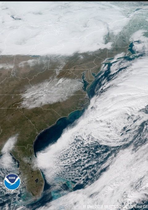
GOES-East satellite image revealing the deep snow pack over Virginia and North Carolina (clouds are seen off the east coast and over the Great Lakes); courtesy NOAA
One final note, this rain event will impact areas south of here as well such as North Carolina and southern Virginia and that raises concerns for potential localized flooding in those particular areas where there continues to be a deep snow pack.
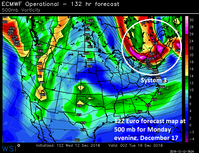
12Z Euro forecast map for Monday evening with a strong wave of energy over New England; courtesy ECMWF, WSI, Inc.
System 3 (Monday, Monday night)
Once the weekend systems push away from the eastern seaboard early next week, the doors will be opened for another shot of cold air to push southeastward from southeastern Canada and there will be quite unstable conditions as the upper atmosphere will again feature a powerful wave of energy. The result may be strong NW winds late Monday and Monday night in the Northeast US as well as numerous snow showers; especially, in higher elevation locations and those spots just downstream from the Great Lakes.
Sneak peek at Christmas
Looking ahead, temperatures are likely to modify later next week, but there are signs for a return to colder-than-normal conditions to return to much of the eastern US during Christmas week. In fact, the latest model run of the ensemble version of the GFS (i.e., 12Z GEFS) features quite cold air in much of the eastern US on Christmas morning, Tuesday, December 25th, and there are liable to be a couple of snow threats during Christmas week…stay tuned.
Meteorologist Paul Dorian
Perspecta, Inc.
perspectaweather.com
Video discussion: