11:15 AM | *Complex weekend storm system to bring the Mid-Atlantic region rain initially and then the real chance for a mixing with or changeover to snow and/or sleet*
Paul Dorian

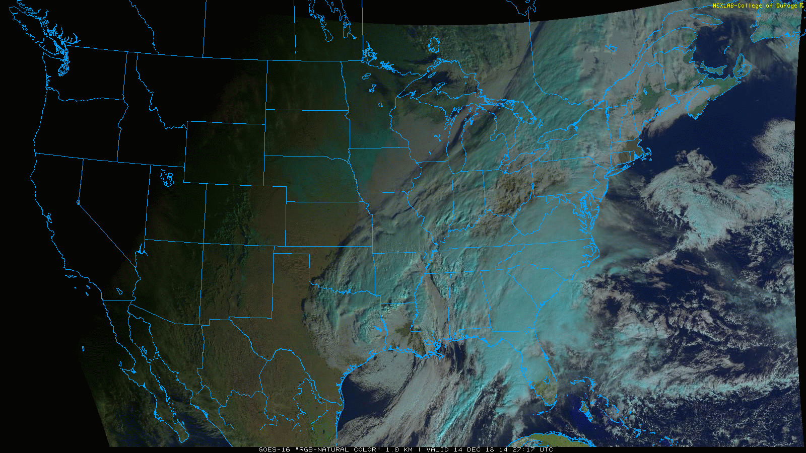
“Natural” color imagery loop of the unfolding complex storm system in the eastern US on Friday morning; courtesy NOAA/GOES-16, College of DuPage
Overview
A complex weather pattern is unfolding for the weekend that will feature multiple surface low pressure systems supported all weekend by the volatile combination of a deep and slow-moving wave of upper-level energy. As a result, the threat for precipitation will extend from late today into Sunday night and it is likely to come in two waves. The front end is likely to feature occasional plain rain in the Mid-Atlantic region from late today into early tomorrow night, but the back end forecast becomes a bit trickier for the period from late tomorrow night into Sunday night. Colder air will seep into the Mid-Atlantic region during the second half of the weekend and this could lead to a mix with or a changeover of the rain to snow and/or sleet; especially, in areas to the north and west of the big cities along the I-95 corridor. Another cold shot will arrive late Monday following the departure of the complex weekend storm and NW winds will become quite strong by Monday night and early Tuesday as Arctic air floods the region.

12Z NAM (12-km version) forecast maps at 500 mb for the next 72 hours (Friday morning to Monday morning) with a deep upper-level low moving from the Deep South to the Tennessee Valley and then to the Mid-Atlantic coastline; courtesy NOAA/EMC, tropicaltidbits.com
Details
The threat for precipitation around here will be for an extended period of time and will not completely cease until an impressive upper-level feature pushes off the east coast by late Sunday night or early Monday. Rain will spread into the DC metro region late in the day and to the Philly metro region in the overnight hours. However, it appears that the heaviest rain in this initial burst of precipitation from this complex storm system will largely be suppressed to the south of the PA/MD border by stubborn cold, high pressure to the north. A second batch of precipitation will arrive tomorrow night and continue on Sunday and that is when the trouble may begin as colder air filters in from the north.
In the upper atmosphere, a very potent wave of energy is currently located in the Deep South and it is beginning a push to the northeast. The upper-level system will be a slow-mover over the next 72 hours which is always troublesome when there is cold air around as there is in this unfolding pattern. The strong upper-level low will move from the southern states to the Tennessee Valley and then just to the south of the DC-to-Philly-to-NYC corridor by late in the weekend.
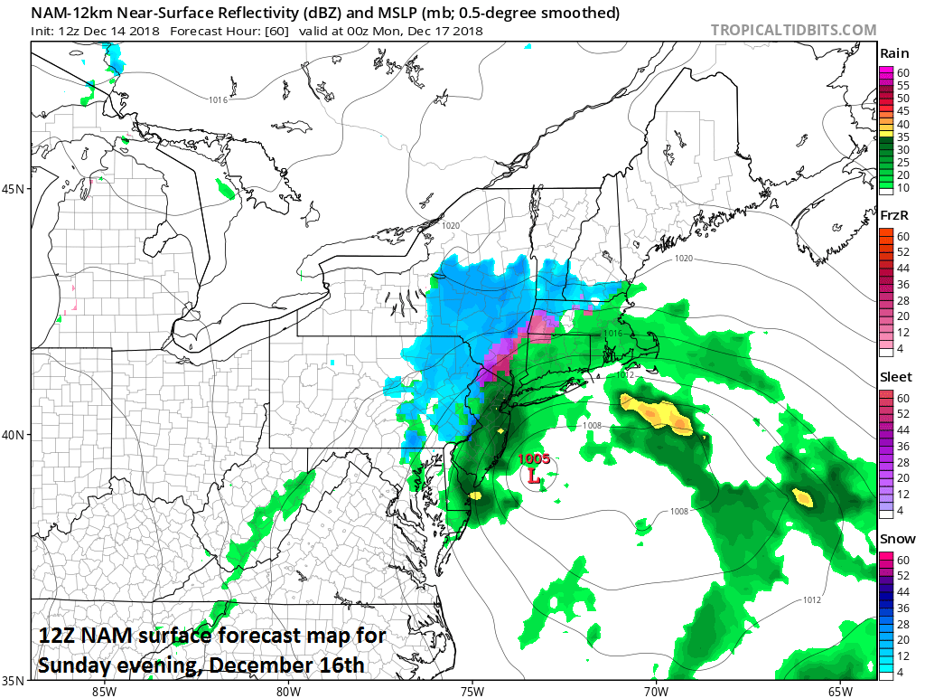
12Z NAM (12-km version) surface forecast map for early Sunday evening (snow in blue, rain in green/yellow, ice in pink/purple); courtesy NOAA/EMC, tropicaltidbits.com
At the surface, there will be one low pressure system pushing slowly to the northeast over the next 24 hours from the Deep South and into the Tennessee Valley. Another low pressure system will form near the Mid-Atlantic coastline late tonight and then head out-to-sea by late tomorrow. The Tennessee Valley low - supported by tremendous upper air energy - will then slide towards the Mid-Atlantic coastline by early Sunday likely moving right across the Delmarva Peninsula to the coastline. Given this potential track, colder air will begin to filter into the region from the north later Saturday night and into the day on Sunday as low-level winds increase in intensity out of the northeast. Temperatures will reach noticeably milder levels later today and remain relatively mild overnight and for much of the day on Saturday; however, as the surface and upper-level lows slide just south of here, they’ll likely drop to the 30’s on Saturday night and then struggle to escape the 30’s on Sunday in much of the Mid-Atlantic region. Rain could very well mix with or change to snow and/or sleet on Sunday or Sunday night from northwest-to-southeast as the colder air continues to seep in on the back side of the surface low pressure system near the Mid-Atlantic coastline and small accumulations cannot be ruled out.
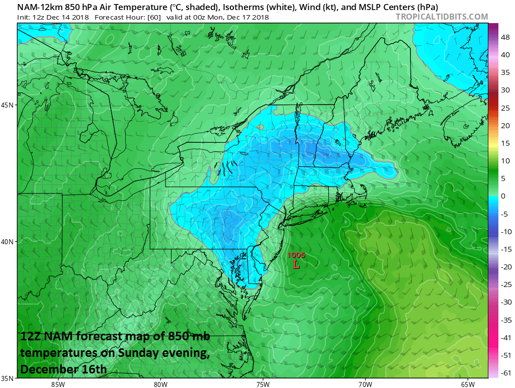
An impressive influx of cold air by Sunday evening into the Mid-Atlantic region on the back side of coastal low pressure; courtesy NOAA/EMC, tropicaltidbits.com
Once this complex storm system pushes off the east coast early Monday, the doors will open for another blast of Arctic air. Winds will increase noticeably as the day progresses on Monday out of the northwest and they’ll continue to be quite strong into Tuesday and temperatures will drop once again to below-normal levels for this time of year.
Meteorologist Paul Dorian
Perspecta, Inc.
perspectaweather.com
Video discussion: