
12:10 PM | ***Accumulating snow on the way for DC, Philly, NYC metro regions***
Paul Dorian

12Z NAM (high-resolution 3-km version) total snowfall forecast map for the upcoming weekend system; courtesy NOAA/EMC, tropicaltidbits.com
Overview
A fast-moving, but potent system will produce accumulating snow in the DC-to-Philly-to-NYC corridor late tomorrow and tomorrow night and some spots can receive several inches by early Sunday morning. Much colder air pours into the region late today and tonight as NW winds increase in intensity and then low pressure will head from the southern states on Saturday to a position off the Mid-Atlantic coastline by later tomorrow night. Following the winter weather this weekend, much warmer air will flood the region next week and highs by Tuesday and Wednesday may pass the 70 degree mark in much of the I-95 corridor - in other words, the snow will not last for long.

12Z NAM (high-resolution 3-km version) surface forecast map for 5 PM Saturday (snow in blue, rain in green, ice in pink/purple); courtesy NOAA/EMC, tropicaltidbits.com
Details
Temperatures started the day in the 50’s and 60’s along the I-95 corridor, but big changes are on the way over the next several hours. A strong cold front is now slowly working its way through the region from northwest-to-southeast and NW winds will intensify this afternoon and temperatures will begin to drop. At noon, temperatures were already down to 31 degrees in Erie, PA and 38 degrees in Pittsburgh, PA with the cold air pushing towards the I-95 corridor. The brunt of this new cold air mass will arrive in the overnight hours and low temperatures by early tomorrow will be in the 20’s across the region.

12Z NAM (high-resolution 3-km version) surface forecast map for 7 PM Saturday (snow in blue, rain in green, ice in pink/purple); courtesy NOAA/EMC, tropicaltidbits.com
On Saturday, cold high pressure will start the day directly overhead and then it'll move to a position off the Northeast US coastline by late in the day. With the high pressure system moving off the coastline, the door will open for precipitation associated with an intensifying low pressure system to advance our way from southwest-to-northeast. This low pressure will move from the southern states to a position off the Mid-Atlantic coastline by later tomorrow night and the result will be accumulating snow for the DC-to-Philly-to-NYC corridor.
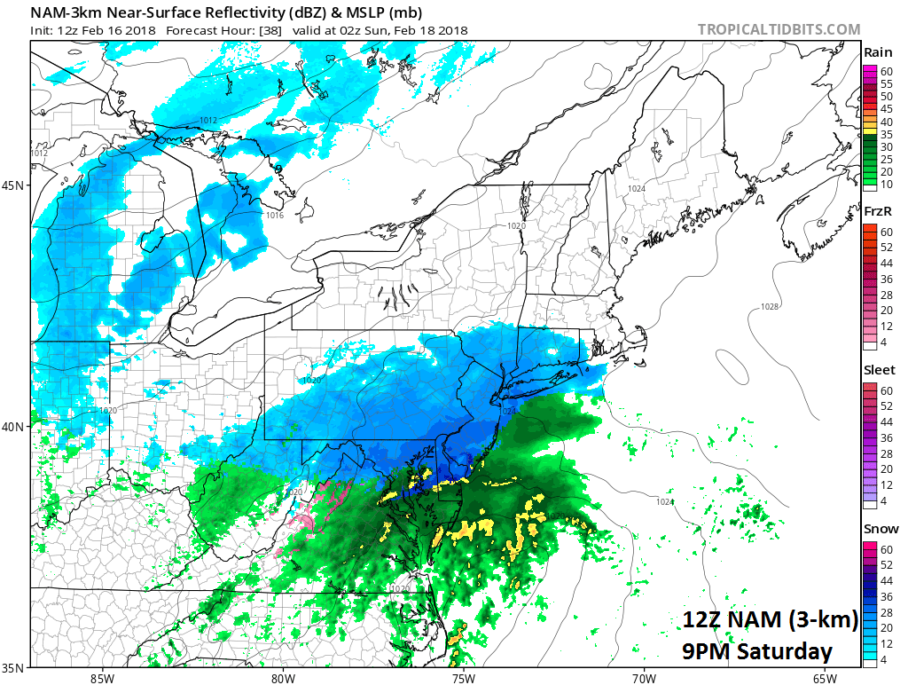
12Z NAM (high-resolution 3-km version) surface forecast map for 9 PM Saturday (snow in blue, rain in green, ice in pink/purple); courtesy NOAA/EMC, tropicaltidbits.com
Snow is likely to arrive in the DC metro region between 3 and 5 pm, and into Philly between 5 and 7 pm, and into New York City between 6 and 8 pm and with vigorous energy in the upper atmosphere, snowfall rates could be 1+ inches per hour during the initial phase of the storm. The precipitation is likely to stay primarily in the form of snow throughout this event in the Philly and NYC metro regions although sleet can certainly mix in at times. In the DC metro region, where it is a more difficult call on the precipitation type, snow is likely to change to a wintry mix fairly quickly in the immediate District region and to points south and east of there, but it should hold on longer as mainly snow in the northern suburbs (e.g., Rockville, MD, Frederick, MD). [There is a chance that the snow holds on longer as well in the District and points south and east in which case their accumulations will be bumped up to the 2-4 inch range as well matching the northern suburbs].
The current snowfall estimates are as follows: 2-4 inches in the northern suburbs of DC with a coating to 2 inches in the immediate District region and to nearby points south and east. The Philly and NYC metro regions can expect 3-5 inches of snow with the higher amounts in that range in the northern/western suburbs and the lesser amounts on the nearby southeast side of the cities. Little or no snow accumulation is expected at the southern New Jersey and Delmarva coastlines where rain will cut way down on any prospective snow accumulations. The precipitation ends in all areas by very early Sunday morning as it is a fast-moving low pressure system. The surface forecast maps from the 12Z high-resolution (3-km) version of the NAM are shown (5, 7, 9 PM) as well as the model forecast map of total snowfall accumulation (using Ferrier method for snow accumulation). [High-resolution computer forecast models such as the 3-km version of the NAM are shown here in this posting as they tend to have a better handle on such mesoscale features as the rain/snow line when this close to event time].

12Z GEFS 850 mb temperature anomalies for Tuesday, February 20th with much warmer-than-normal conditions in the Northeast US; map courtesy NOAA/EMC, tropicaltidbits.com
Following the winter weather this weekend, another big warm up is coming to the Mid-Atlantic region by the middle of next week in what is still an on-going overall mild weather pattern. In fact, temperatures should climb to at least the 60’s in DC, Philly and NYC by Tuesday and Wednesday of next week and perhaps into the 70's in some spots. Longer term, signs still point to a return to a colder-than-normal pattern as we head into the month of March and the month of March is looking quite interesting indeed.
Meteorologist Paul Dorian
Vencore, Inc.
vencoreweather.com
Detailed video discussion on the upcoming weekend storm: