
12:05 PM | *Interesting pattern to unfold near the east coast at the end of next week*
Paul Dorian

12Z Thurs Euro 500 mb height forecast map for Saturday morning, March 3rd, with a deep upper-level low situated right near the Mid-Atlantic coastline and strong ridging near Greenland; map courtesy WSI, Inc.
Overview
Record-warmth has been swept away from the Mid-Atlantic region by an overnight passage of a cold frontal system and the next couple of days will stay on the chilly side with occasional rain or drizzle. The weekend will feature milder conditions although still on the wet side and then much of next week looks relatively mild for this time of year. By the end of next week; however, important changes will be taking place to the overall upper-level pattern across North America. A deep upper-level trough of low pressure will begin to retrograde (i.e., move from east-to-west) to the east coast at the same time strong high-latitude blocking forms over northeastern Canada and Greenland. The ultimate result is likely to be a strong storm near the east coast at the end of next week and with colder air potentially wrapping into the system, accumulating snow may very well become a real threat in parts of the Mid-Atlantic region and Northeast US by the first weekend of March.
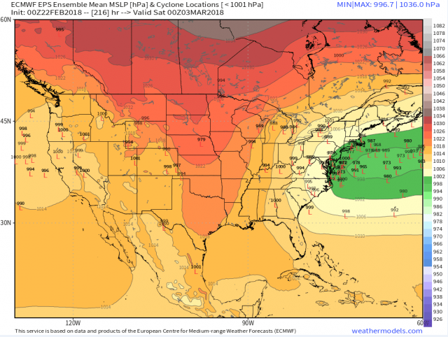
00Z Euro forecast map of low pressure locations for multiple "ensemble members" as of Friday night, March 2nd, with a "cluster" of storms near the Mid-Atlantic coastline; map courtesy weathermodels.com (Dr. Ryan Maue)
Discussion
The overall weather pattern looks like it will change significantly by the early part of March. Yesterday, there was an extremely strong (and perhaps record-breaking) upper-level ridge of high pressure over the western Atlantic, but in about a week-to-ten days, this same region is likely to feature a deep trough of low pressure. At the same time, strong blocking in the upper part of the atmosphere will take hold in the northern latitudes (northeastern Canada/Greenland) and this combination will result in a better chance for cold air masses to plunge into the eastern US as the month of March gets underway. In addition to these two changes at 500 mb, a ridge of high pressure will retrograde to a position over the Rockies, and yet another trough will move westward from the US west coast to the eastern Pacific Ocean.
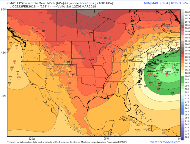
00Z Euro forecast map of low pressure locations for multiple "ensemble members" as of Saturday morning, March 3rd, with a "cluster" of storms just off the Mid-Atlantic coastline; map courtesy weathermodels.com (Dr. Ryan Maue)
This potential upper-level pattern across North America would not only likely result in colder-than-normal air for the Mid-Atlantic region as we begin March, but it also allows for the possibility of a strong storm along the east coast or over the western Atlantic Ocean. In fact, recent versions of the European computer forecast model have the look of a strong coastal storm at the end of next week. For example, its 00Z forecast maps of potential surface low pressure locations for multiple "ensemble members" as of next Friday night (March 2nd) and Saturday morning (March 3rd) support the idea of a strong coastal storm as we begin the month of March. The Euro model forecast map at 500 mb for Saturday morning, March 3rd, features a deep upper-level trough situated over the Mid-Atlantic coastal region and high-latitude blocking across northeastern Canada and Greenland. This is likely to be a slow-moving system that could begin as rain in the Thursday/Friday time frame in the Mid-Atlantic region, but then as colder air wraps into intensifying low pressure over the western Atlantic, accumulating snow could very well develop in at least portions of the region by the first weekend of March.
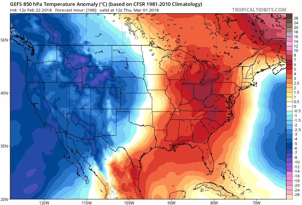
850 mb temperature anomalies reflect colder-than-normal conditions for much of the nation in the period of March 1st - March 10th; maps courtesy tropicaltidbits.com, NOAA/EMC
As far as temperatures are concerned, the overall pattern looks like it will change to generally below-normal for much of the nation during the first ten days of March. The 12Z GEFS loop of 850 mb temperature anomalies reflects this significant change in the overall temperature pattern for the eastern US and much of the nation.
Stay tuned, there could be quite a storm over the western Atlantic Ocean in a week-to-ten days.
Meteorologist Paul Dorian
Vencore, Inc.
vencoreweather.com