12:20 Sunday PM | **Snow from yet another unfolding intense ocean storm**
Paul Dorian
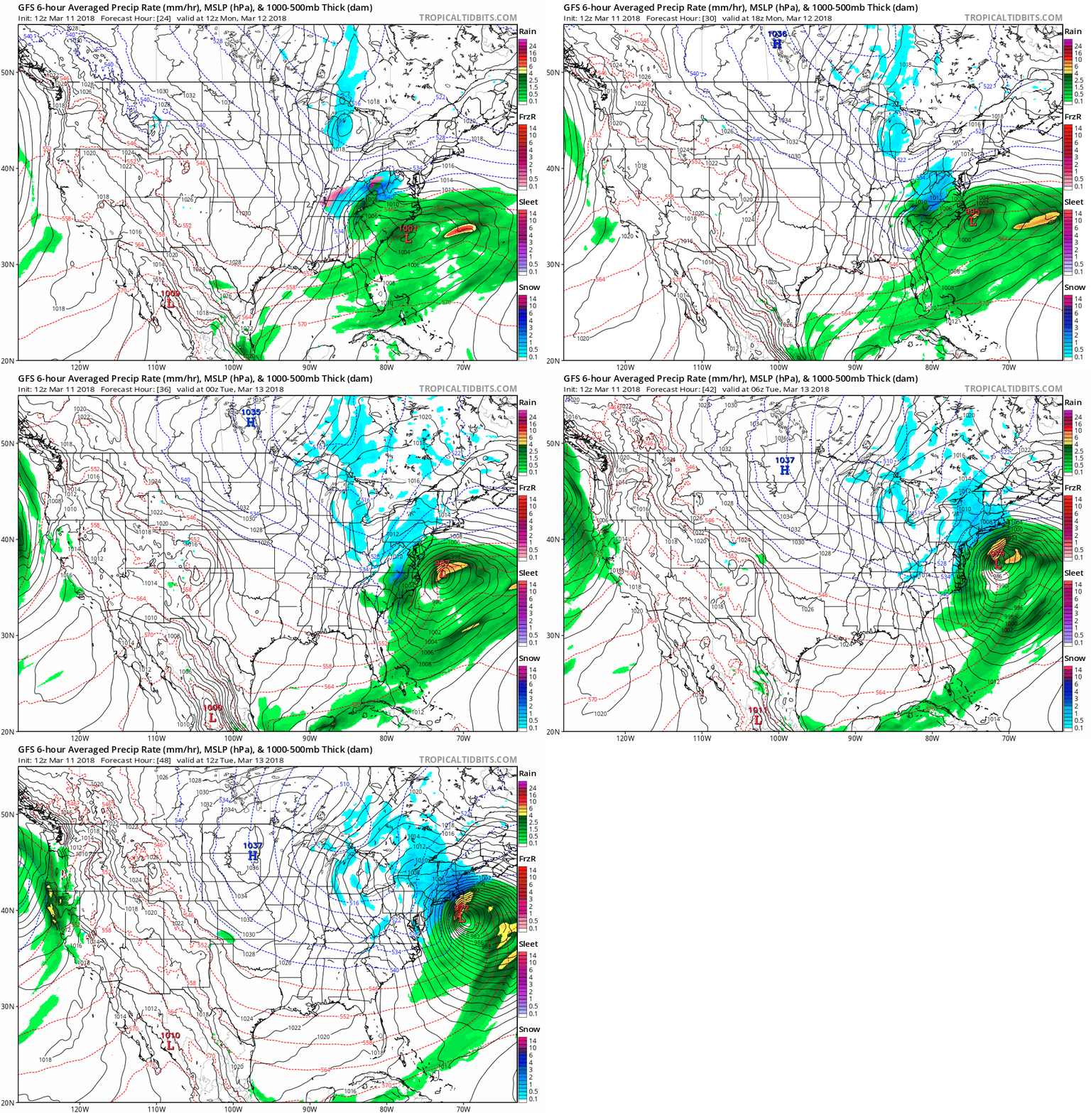
12Z Sunday GFS surface forecast maps in 6-hour increments from hour 24 (Monday morning) to hour 48 (Tuesday morning); courtesy NOAA/EMC, tropicaltidbits.com
Overview
Our recent cold and stormy March weather pattern continues this week with yet another ocean storm to deal with in the Mid-Atlantic/Northeast US. Strong low pressure will head towards the Carolina coastline on Monday morning and then take a turn to the northeast and intensify along the way as it heads to a position off the NJ coastline by early Tuesday and then off of eastern New England by late Tuesday. It looks like the storm will come close enough to the Mid-Atlantic coastline to generate some snow for the DC-to-Philly-to-NYC corridor, but exactly how close it comes to the coast is still somewhat of an open question and the precise track will help determine if this is a nuisance snow or something more significant. As with the prior coastal storms, the impact looks greater as one moves northeast along the coastline so that, for example, DC likely gets impacted less than NYC, and it could become an all-out blizzard for eastern New England.
Two key players in the upper atmosphere for the upcoming event include one wave of energy in the northern branch of the jet stream and one in the southern branch; map courtesy NOAA/EMC, tropicaltidbits.com
Discussion
In addition to the persistent high-latitude blocking to our north, two key players in the upcoming storm threat will be separate waves of energy in the northern and southern branches of the jet stream. These waves will ultimately consolidate into one deep upper-level trough over the Northeast US by Tuesday/Wednesday as a powerful storm churns by that time slowly northeastward off the eastern New England coastline. The latest models generally tend to phase these upper-level systems in time to produce some snow in the DC, Philly and NYC from tomorrow into early Tuesday, but there is still some question as to how close the storm will actually come to the Mid-Atlantic coast and low-level temperatures will be an issue; especially, in the DC metro region. A close-in track would result in a more significant snowfall for the I-95 corridor whereas a movement to a position well off the Mid-Atlantic coastline would produce a nothing more than nuisance snow.
Given the cold air mass in place, snow would likely be the favored precipitation type during this event in the immediate I-95 corridor; however, rain could be mixed in for awhile at the onset in Philly and NYC and perhaps throughout the event in the DC metro region. Closer to the coast (e.g., coastal NJ), there is likely to be some accumulating snow even with rain possible for a brief time at the onset. The precipitation would likely begin during the mid-day hours in the DC metro region on Monday, later in the afternoon in Philly, and early evening in NYC. “Daytime” snowfall in the DC metro region would make it more difficult for snow accumulations in that area whereas in Philly and NYC, the timing might be just right to allow for some nighttime snow accumulations (i.e., during Monday night). Preliminary snowfall estimates for this upcoming event are a coating to an inch or two in the DC metro region, 1-3" in Philly, and 2-4 inches in NYC.
Stay tuned.
Meteorologist Paul Dorian
Vencore, Inc.
vencoreweather.com


