12:30 PM | **”March Madness”…no signs of spring and another potential nor’easter**
Paul Dorian
Three nor'easters have occurred this month and there are strong signs for a fourth one next week; images courtesy Weather Optics, NOAA
Overview
If you had a chance to bet on the over/under for the number of nor’easters this month, I hope you took the over. There have been three nor’easters in the past ten days or so and there is the threat for another one around Tuesday of next week. In fact, as we approach the middle of March, it is hard to find any sign of sustained spring-like weather for the Mid-Atlantic/Northeast US and the colder-than-normal temperature pattern is looking like it will go right into early April. In addition, instability in the upper-atmosphere will bring much of the region snow showers this afternoon with isolated snow squalls and perhaps a repeat tomorrow afternoon.
06Z GEFS shows no sign of warmer-than-normal in the Mid-Atlantic/Northeast US during the next 15 days; maps courtesy NOAA/EMC, tropicaltidbits.com
General Discussion
Back in the 1950’s, 1960’s and 1970’s, the month of March was quite often colder-than-normal in the Mid-Atlantic region and this year is certainly heading in that direction. In that same time period, there were several years featuring multiple nor’easters in a short period of time - similar to what we are experiencing this year. For example, three nor’easters took place in a short period of time in January 1966, and again during February/March 1969, and again in January 1978. We have had three nor’easters this month and a fourth is possible next week and some long-range models even suggest a fifth could occur towards the end of the month.
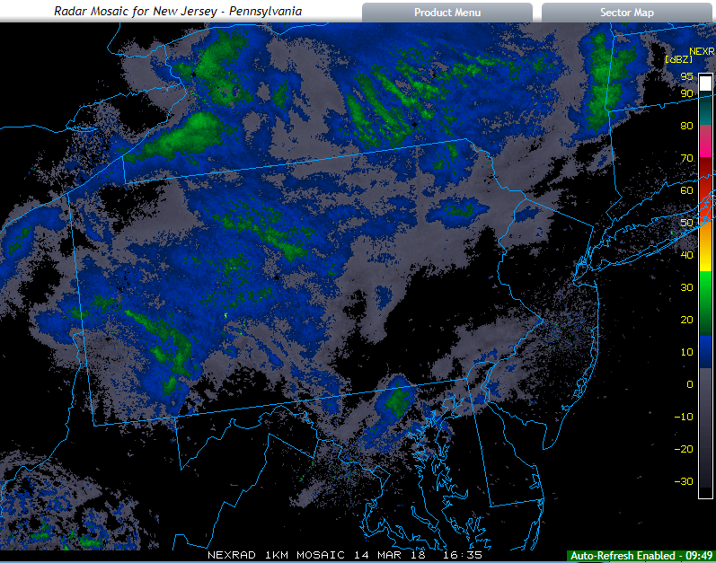
Mid-day radar with numerous snow showers in upstate PA which could work their way into the I-95 corridor later this afternoon; courtesy College of DuPage, NOAA
Short-term threat
One of the main keys to the recent cold and stormy pattern we are experiencing in the Mid-Atlantic/Northeast US is strong high-latitude blocking (negative NAO) positioned to our north over northern Canada and Greenland. This blocking pattern will continue to be a factor for the foreseeable future. As a result of the blocking, the deep upper-level trough of low pressure now over the Northeast US will be held at bay and short-wave pieces of energy will rotate through over the next couple of afternoons. One such short-wave will cause very unstable conditions later today and this will contribute to strong wind gusts of up to 40 mph or so in the DC-to-Philly-to-NYC corridor. In addition, numerous snow showers are likely to form this afternoon over the higher elevation of upstate PA and then likely move across eastern PA, NJ this afternoon perhaps even down into the DC metro region. Furthermore, an isolated snow squall or two may develop this afternoon which could result in a quick accumulation in a given area with a rapid drop in visibility. Another upper-level wave of energy looks like it will rotate through the deep upper-level trough on Thursday afternoon and this too could cause some shower activity; however, temperatures later tomorrow will be a tad warmer than today so any shower that forms tomorrow could be in the form of rain some kind of a mix whereas snow is most likely today.
12Z GFS forecast map for next Tuesday afternoon, March 20, with yet another nor'easter in the making; map courtesy NOAA/EMC, tropicaltidbits.com
Next week’s coastal storm threat
Looking ahead, after what appears to be a relatively quiet and mild weekend, the overall weather pattern will get quite interesting again early next week. There are signs that high-latitude blocking will re-establish itself to our north after a break for a few days and this will allow for colder air to return to the Northeast US on Monday. At the same time, low pressure will be trekking across the country towards the Ohio Valley region by Tuesday. At this time, energy could transfer to the Mid-Atlantic coastline and form yet another nor’easter which could produce more late-season snow for at least the interior sections of the Mid-Atlantic and Northeast US. Stay tuned…still several days away.
DC snow jinx
One final note, with three nor’easters in the past ten days or so, one would think DC got in on some of the action as far as snow accumulations are concerned. Not really, there have been some “coatings” of snow in the DC metro region, but certainly nothing significant this winter – at least not so far. It is not, however, the least snowy winter in DC’s history. That honor goes to the El Nino winter of 1997-1998 when the region saw 0.1 inches of slush. This year Reagan national Airport (DCA) has recorded 3.7 inches of snow which ranks as the 11th wimpiest winter on record. The average seasonal snowfall at Reagan National Airport is 15.4 inches. Dulles Airport averages 22 inches of seasonal snow, but little more than 6 inches has fallen there so far. By the middle of March, the odds of measurable snow decrease markedly in the DC metro region. In fact, the average latest date of accumulating snow for the District has already passed. There have been a couple of accumulating snow events during the month of April in DC including half an inch that fell on April 7, 2007 and the latest measureable snow on April 28, 1898 when half an inch was recorded downtown. All it takes is one big storm to erase all of the bad memories of this winter for snow lovers in the DC metro area and stranger things have happened.
Meteorologist Paul Dorian
Vencore, Inc.
vencoreweather.com
Extended morning video discussion


