11:20 AM | **April to start with a “wall of cold”**
Paul Dorian

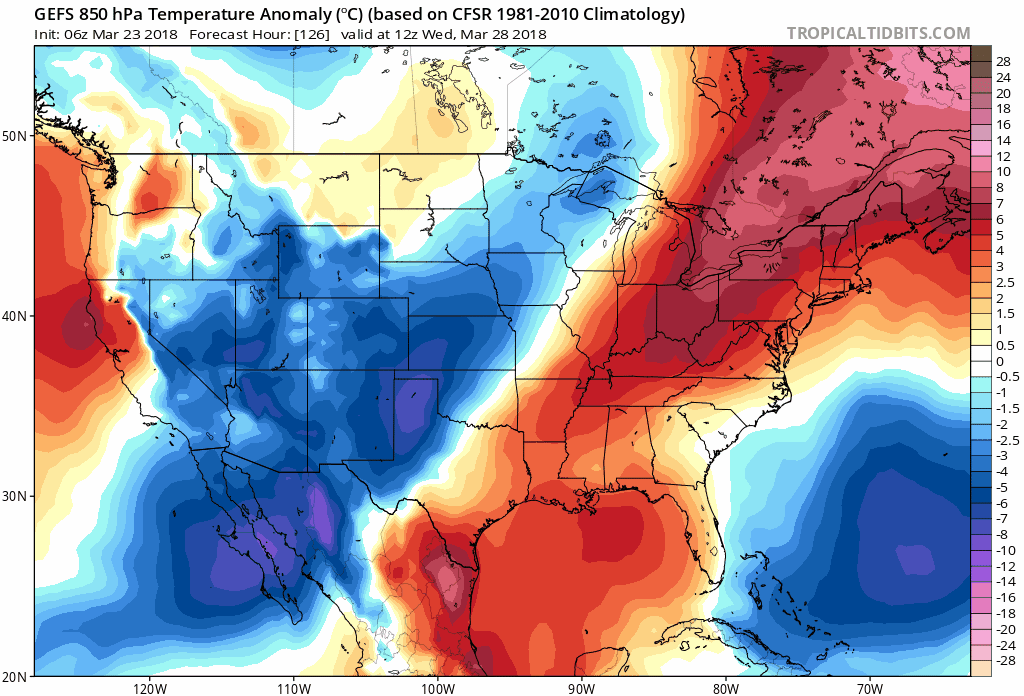
06Z GEFS forecast maps of 850 mb temperature anomalies for the 5-day period from Wednesday, March 28th to Monday, April 2nd with a "wall of cold" expanding later in the period from southern Canada into the northern US. courtesy NOAA/EMC, tropicaltidbits.com
Overview
There will be a noticeable warm up next week in the Mid-Atlantic region, but it looks like it’ll be just a temporary spring tease as colder-than-normal conditions are likely to return in time for the beginning of April and they may continue right into the middle of the month. A colder-than-normal air mass will first appear later next week across southwestern and south-central Canada and then expand south and east so that by next weekend there will be a “wall of cold” virtually covering all of southern Canada and the northern US including right here in the Mid-Atlantic region.

06Z GEFS forecast map of 500 mb height anomalies on Easter Sunday, April 1st with large area of below-normal heights centered over Canada and the northern US (blue) and the return of high-latitude blocking over Greenland (orange); courtesy NOAA/EMC, tropicaltidbits.com
Discussion
Temperatures will remain below-normal right through the upcoming weekend in the DC-to-Philly-to-NYC corridor and into the early part of next week. Highs are supposed to be around 55 degrees right now in Philly, 58 degrees in DC, and 52 degrees in New York City, but they’ll generally hold in the 40’s through Monday of next week. By Tuesday, it’ll turn noticeably milder with highs back to 50 degrees (still below-normal though) and then perhaps to the 60 degree mark for highs by next Thursday.

06Z GEFS forecast map of 850 mb temperature anomalies on Easter Sunday, April 1st with large area of colder-than-normal centered over Canada and the northern US; courtesy NOAA/EMC, tropicaltidbits.com
By the latter part of next week, an upper-air pattern will be unfolding that will ultimately allow for cross-polar flow and the penetration of cold air masses from Canada into the central and eastern US. Deep upper-level low pressure will set up over Canada and begin to expand to the south and east at the same time high-latitude blocking returns over Greenland (-NAO) and strong ridging pops up near Alaska (-EPO).
Cold air will be building across Canada later next week and Gulf of Mexico moisture will begin to flow northward into the Deep South. Low pressure is likely to form in the Deep South by Thursday and ride northeastward along a developing cold frontal boundary zone. The low pressure area and its accompanying cold frontal system are likely to arrive in the Mid-Atlantic region on Friday (March 30) perhaps with quite decent rainfall, and likely act as the transition between the (temporary) warmer weather of next week to the colder-than-normal weather expected for the first half of April.

Snowfall totals from the great spring snowstorm of April 6-7, 1982; courtesy NOAA
The snowstorm of April 6-7, 1982
Can we get accumulating snow in the Mid-Atlantic region during the month of April…sure, and one such example took place on April 6-7, 1982. This particular event turned into an all-out blizzard for New York City and much of the Northeast US and delayed the baseball season in many cities from Baltimore-to-Boston. It resulted in significant snow of more than a foot in many places from Pennsylvania-to-New England and winds gusted to 70+ mph in spots during the storm. Also, record cold poured in on the back side of the storm with many spots falling to 25 degrees below normal for that time of year shortly after the storm had passed. We’ll monitor the prospects for snow around here in April as we proceed through next week, but one thing is quite certain, colder-than-normal weather should return by early April after a brief warm spell.

Satellite images of four nor'easters during the month of March and this has led to the second snowiest March ever for Philly (courtesy NOAA)
One final note, this has become the second snowiest March in Philly history with 15.2 inches so far…the record March came in 1941 with 17.7 inches.
Meteorologist Paul Dorian
Vencore, Inc.
vencoreweather.com
Extended morning video discussion on the “wall of cold” coming by the beginning of April: