11:25 AM | **Despite the current warmth, accumulating snow is actually on the table for late Sunday night/early Monday**
Paul Dorian
12Z NAM surface forecast map for early Monday morning with snow (in blue) in the Mid-Atlantic; map courtesy NOAA/EMC, tropicaltidbits.com
Overview
Temperatures at mid-day on Friday are near 70 degrees in the DC metro region and in the 60’s in the Philly and NYC metro regions, but next week continues to look quite different with colder-than-normal air masses headed our way. In additional to the colder air masses, there are two snow threats that will have to be monitored – one late Sunday night into early Monday and then another is possible at the end of next week or next weekend.
Record or near record cold across Canada early Friday (circled) and this will be a source region for cold here in the Mid-Atlantic during the first part of April; map courtesy coolwx.com
Temperatures
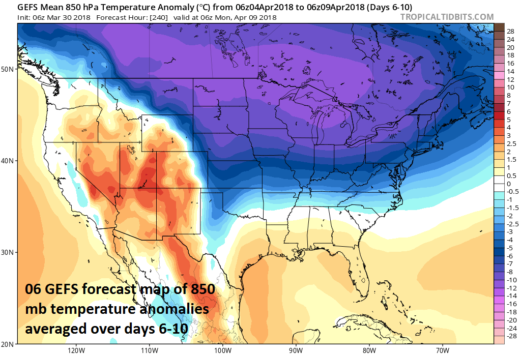
At the same time the eastern US warmed up noticeably during the past couple of days, a much colder-than-normal air mass has expanded over central Canada where there is now some record or near record cold. It is from this source cold region that cold air outbreaks will originate over the next couple of weeks before they drop to the south and east and likely result in numerous days with below-normal temperatures in the Mid-Atlantic region during the first ten days or so of April. Not every day will be colder-than-normal, but the average over 5-day periods during the first part of April are likely to be below-normal in the DC-to-Philly-to-NYC corridor (days 6-10 shown below). A cold frontal system is pushing through the region today and it will usher in colder air mass for tonight and Saturday and then a second cold front will arrive early Sunday and it’ll be followed by a chilly air mass to start next week. A third cold front will arrive at mid-week and it’ll usher in a colder air mass for late next week and next weekend.
12Z NAM forecast map of 2-meter temperatures early Monday which should be supportive of snow in the DC-to-Philly-to-NYC corridor; map courtesy NOAA/EMC, tropicaltidbits.com
Snow threats
There will be a couple different low pressure systems to monitor next week as our pattern turns colder and snow cannot be ruled out with either system. The first threat of snow comes late Sunday night and early Monday when low pressure will head eastward in the southern part of the Mid-Atlantic region and temperatures could be just cold enough for snow to fall in the DC-to-Philly-to-NYC corridor. In fact, there is a chance for some snow accumulations to begin the new work week aided in part by the favorable timing of the potential snow (i.e., not during the daytime when the April sun inhibits chances). The most recent computer forecast models have become more and more impressed with this particular wave of low pressure and have expanded its precipitation field a bit farther to the north and have increased its intensity as well.
06Z GEFS forecast map of 850 mb temperature anomalies averaged over a 5-day period from April 4 to April 9 (days 6-10); map courtesy NOAA/EMC, tropicaltidbits.com
By late next week, another cold air mass for this time of year originating from central Canada will arrive in the Mid-Atlantic region and it could set the stage for quite an interesting scenario right around the anniversary of the great April blizzard in 1982 (April 6-7). Low pressure may have to be dealt with at the end of next week or next weekend and the air in place should be quite cold for this time of year...stay tuned.
Meteorologist Paul Dorian
Vencore, Inc.
vencoreweather.com


