12:55 PM | *****Heaviest snow on Wednesday to occur north and west of the metro regions…mixing in the big cities will limit accumulations somewhat in those spots*****
Paul Dorian
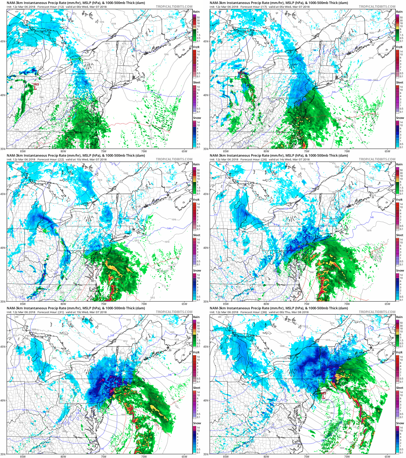
12Z NAM (3-km) surface forecast maps from 7PM tonight to 7PM tomorrow night in hourly increments; maps courtesy NOAA/EMC, tropicaltidbits.com
Overview
An intensifying coastal storm on Wednesday will have a major impact on the I-95 corridor from Philly-to-NYC-to-Boston with significant accumulations of snow in suburban areas to the north and west of these metro regions. In the big cities, the precipitation will likely be mixed for several hours during this event and this would limit somewhat overall accumulations in those particular areas. As far as the DC metro region is concerned, much of the intensification with this coastal storm will take place to the northeast and this will limit the overall impact in that area, but some accumulating snow is still on the table. The snow will be of the heavy, wet variety and, unfortunately, this can lead to a fresh round of power outages.
Details
Low pressure will develop along the Carolina coast early tomorrow and intensify rapidly while heading to a position near the NJ coastline later in the day. Precipitation should arrive in the DC-to-Philly-to-NYC corridor late today or early tonight and it can go back-and-forth between rain and snow for awhile into the overnight hours. With the close approach of the low to the NJ coastline on Wednesday morning, enough warm air from the ocean may cause the big cities to continue as a mixture for awhile. However, in the northern and western suburbs, colder air will filter in from the north and precipitation is likely to change to all snow during the morning hours.
"Frontogenesis" (purple) later tomorrow could result in heavy snow bands over eastern PA, NJ and southeastern NY; map courtesy NOAA/EMC, tropicaltidbits.com
During the mid-day and afternoon hours, intense “frontogenesis” will take place in the atmosphere and heavy snow bands are likely to develop across eastern PA, NJ and southeastern NY. These small-scale heavy snow bands can cause snow to pile up in a hurry (up to a few inches per hour) and may even include some “thunder snow”. [The 12Z high-resolution NAM (3-km) surface forecast maps for tomorrow display these heavy snow bands (in dark blue, red) and strong “frontogenesis” in eastern PA, NJ, southeastern NY during the mid-day and afternoon hours].
12Z Euro forecast maps for 30 hours (left) and 36 hours (right); courtesy WSI, Inc.
In terms of snowfall, the big cities from Philly-to-NYC-to-Boston will likely experience several hours of rain or a mixture of snow and rain and this will limit overall accumulations to perhaps 2-4 inches with locally higher amounts (e.g., in higher elevations locations). As one moves to the north and west of Philly, NYC and Boston, snow accumulations will rise quickly with 4-8 inches likely in those suburbs and there will likely be locally higher amounts with a foot of snow on the table.
In the DC metro region, snowfall accumulations will be limited as the main intensification of the coastal storm will take place to its northeast. A coating to 2 or 3 inches of snow is still possible in the DC metro region with the higher amounts in that range to the north and northeast of the District and the lower amounts to the south and west.
One final note, power outages have to be mentioned as a real concern for this upcoming event given the expectation of heavy, wet snow which is likely follow some rain.
Stay tuned…any slight change in the storm track can have a big impact on the location of the axis of heaviest snow.
Meteorologist Paul Dorian
Vencore, Inc.
vencoreweather.com
Video discussion:


