7:30 PM (Tuesday evening) | *****Major snowstorm on Wednesday in much of I-95 corridor with the potential of intense snow bands and even “thunder snow”*****
Paul Dorian
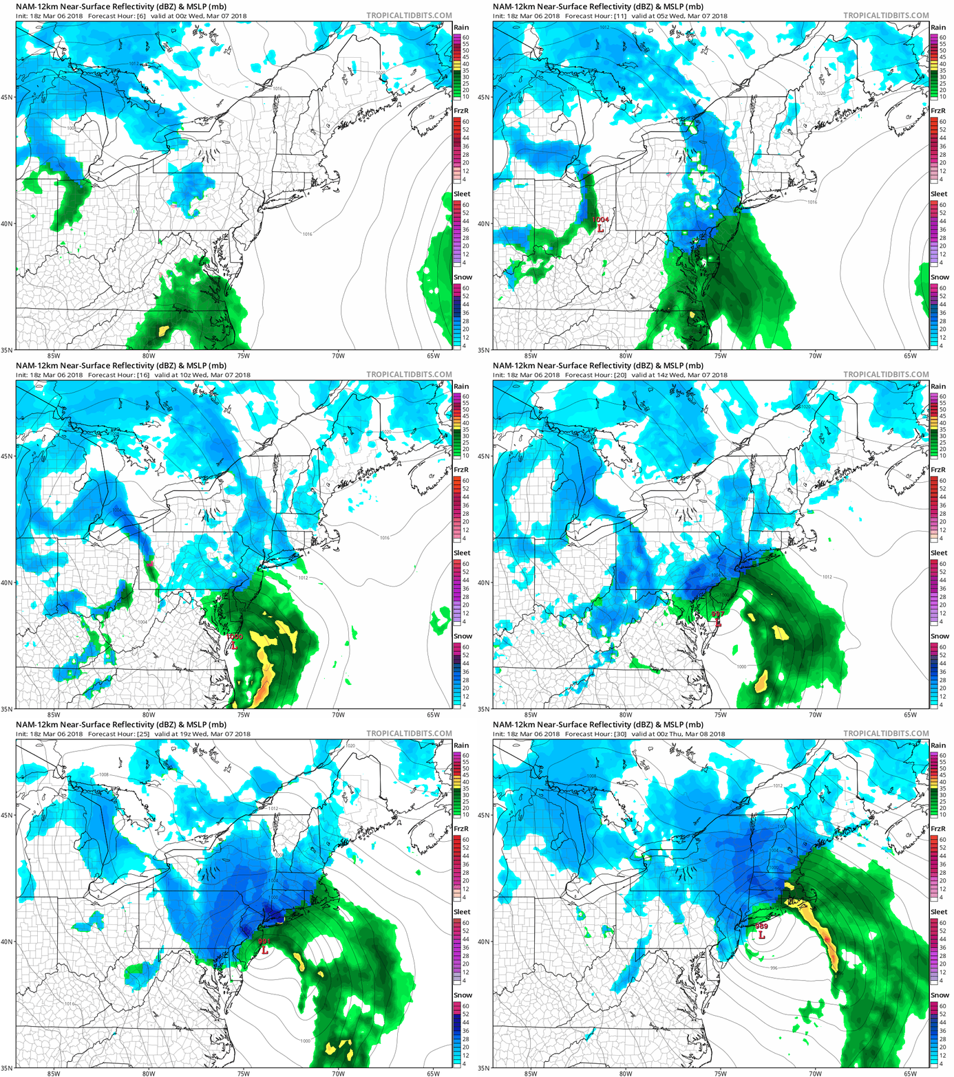
18Z NAM (12-km version) forecast maps from 7pm Tuesday to 7pm Wednesday; maps courtesy NOAA/EMC, tropicaltidbits.com
Overview
An intensifying and very dynamic coastal storm on Wednesday will have a major impact on the I-95 corridor from Philly-to-NYC-to-Boston with significant accumulations of snow in suburban areas to the north and west of these metro regions. In the big cities, the precipitation will likely be mixed for a longer period than in the suburbs and this should limit slightly overall accumulations in those particular spots. In the DC metro region, much of the intensification with this coastal storm will take place to the northeast and this will limit the overall impact in that area, but some accumulating snow is still on the table including in the overnight hourrs. The snow will be of the heavy, wet variety and, unfortunately, this can lead to a fresh round of power outages.
Details
Low pressure will develop along the Carolina coast early tomorrow and intensify rapidly while heading to a position near the NJ coastline later in the day. Precipitation will increase in coverage and intensity in the overnight hours in the DC-to-Philly-to-NYC corridor and it can go back-and-forth between rain, sleet and snow for awhile. As the intensifying storm makes a close approach to the NJ coastline on Wednesday morning, enough warm air from off the ocean may cause the mixture in the big cities to linger for a longer period than in the suburbs. However, in the northern and western suburbs, colder air will filter in from the north and the precipitation is likely to change to all snow by the early morning hours.
18Z NAM forecast map for 3pm on Wednesday with tremendous "frontogenesis" at 850 mb which may cause intense snow bands; map courtesy NOAA/EMC, tropicaltidbits.com
During the mid-day hours on Wednesday the upper-level low associated with the developing coastal surface storm will go negatively-tilted (axis orientation from NW-to-SE) and this will generate strong upward motion in the Mid-Atlantic region. In addition, during the mid-day and afternoon hours, intense “frontogenesis” will take place in the atmosphere and heavy snow bands are likely to develop across eastern PA, NJ and southeastern NY. These small-scale heavy snow bands can cause snow to pile up in a hurry (up to a couple inches per hour) and may even include some “thunder snow”. [The 18Z high-resolution NAM (12-km) surface forecast maps for a 24-hour period from early tonight to early tomorrow night display these heavy snow bands (in dark blue, red) and strong “frontogenesis” in eastern PA, NJ, southeastern NY during the mid-day and afternoon hours].
In terms of snowfall, the big cities from Philly-to-NYC-to-Boston will likely experience a mixture of precipitation for a longer period of time than the suburbs and this will reduce overall accumulation amounts somewhat in those spots to perhaps 4-8 inches though locally higher amounts are possible. As one moves just to the north and west of Philly, NYC and Boston, snow accumulations will rise quickly with 8-14 inches likely in those suburbs with possible locally higher amounts (such as in higher elevation locations).
In the DC metro region, snowfall accumulations in the overnight hours and on Wednesday will be limited compared to places up the coastline as the main intensification of the coastal storm will take place to its northeast. A coating to 2 or 3 inches of snow is still possible in the DC metro region with the higher amounts in that range to the north and northeast of the District and the lower amounts to the south and west.
One final note, power outages have to be mentioned as a real concern for this upcoming event given the expectation of heavy, wet snow which is likely to follow some rain increasing the chances for tree limbs and power lines to be weighed down.
Meteorologist Paul Dorian
Vencore, Inc.
vencoreweather.com


