
10:15 AM | *Major warm up next week as the month of May begins, but not yet the permanent switch to summer*
Paul Dorian
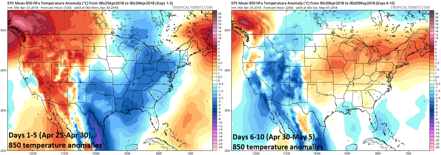
00Z Euro ensemble 5-day average of 850 mb temperature anomalies for days 1-5 (left) and days 6-10 (right); courtesy tropicaltidbits.com, ECMWF
Overview
There will be another chilly shot of air dropping southeastward this weekend into the Northeast US and Sunday will turn out to be cooler-than-normal for this time of year, but there are signs that a major warm up is coming next week. In fact, it looks like the major warm up will coincide quite nicely with the calendar change to May (on Tuesday) with the 80’s quite likely for highs during this warm stretch of weather - perhaps even with a run at the 90 degree mark at some point later next week. Looking even farther ahead, next week’s warm up does not appear to be the end of the cooler-than-normal air masses coming our way as it is likely to turn much cooler again during the second week of the new month.

06Z GFS surface forecast map for Friday afternoon, April 27th, with another low pressure system impacting the Mid-Atlantic region; map courtesy NOAA/EMC, tropicaltidbits.com
Details
It’ll stay cooler-than-normal on average in the Mid-Atlantic region during the current 5-day stretch as several systems have an impact on the region. First, low pressure is slowly working its way through the Mid-Atlantic region today and its associated clouds and rain are helping to keep temperatures confined to below-normal levels. After a nice day tomorrow, another low pressure system will bring us more clouds and showers on Friday – once again suppressing temperatures to below-normal levels. A strong cold front will approach the region on Saturday and while it’ll be mild ahead of it on Saturday, much cooler-than-normal air will return on Saturday night and Sunday as upper-level troughing persists in the eastern US.

00Z Euro ensemble 5-day average of 500 mb height anomalies for days 1-5 (left) and days 6-10 (right); courtesy tropicaltidbits.com, ECMWF
By Tuesday of next week (May 1st), upper-level troughing in the eastern US will begin to be replaced by a strong ridge in the upper part of the atmosphere. As a result, temperatures will surge on Tuesday beginning a warm up that should continue through at least Friday with temperatures really taking off during the latter part of next week. High temperatures well up in the 80’s are quite likely later next week – perhaps there will even be the first flirtation with the 90 degree mark in parts of the I-95 corridor during this warm period.
Next week’s major warm up, however, does not look like the permanent switch to summer just yet. There are signs that yet another batch of cooler-than-normal air will return to the Northeast US for the second week of May and that pattern may persist for awhile before sustained summer-like weather really takes over.
Meteorologist Paul Dorian
Vencore, Inc.
vencoreweather.com