
1:15 PM | **Abnormal April cold returns here this weekend and generally cold pattern continues into the second half of the month…low pressure that “hangs back” on Saturday still has to be monitored**
Paul Dorian
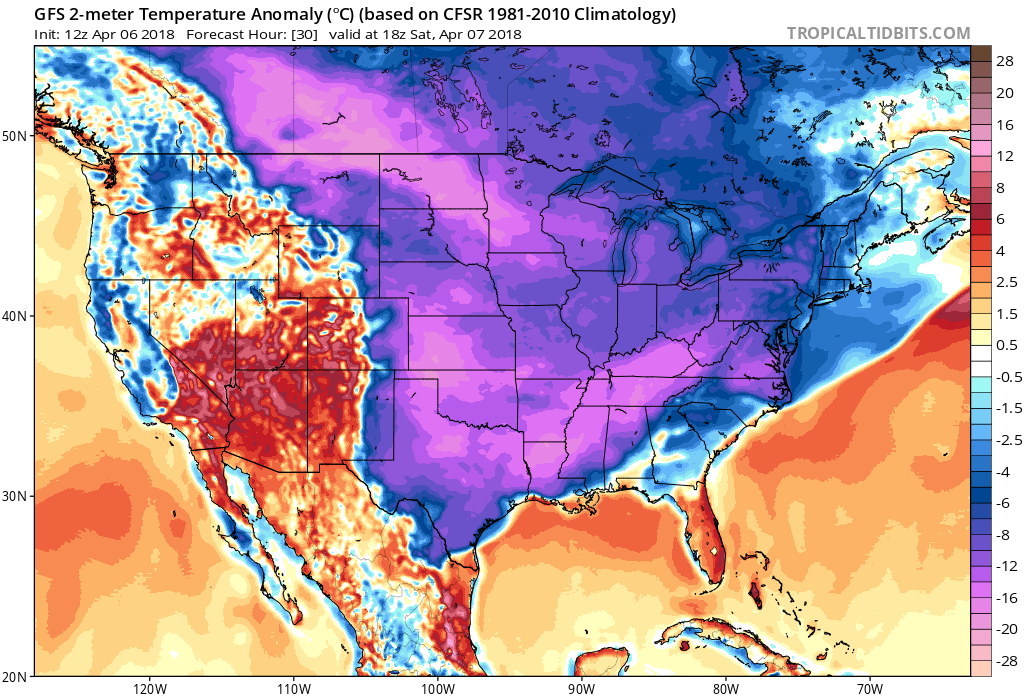
12Z GFS forecast map of 2-meter temperature anomalies for tomorrow afternoon with a widespread area of the eastern two-thirds of the nation well below-normal for this time of year; courtesy NOAA/EMC, tropicaltidbits.com
Overview
It is currently about as cold as it ever gets during the month of April in the Northern Plains and Upper Midwest and it’ll turn much colder here in the Mid-Atlantic region this weekend following a brief spike in temperatures this afternoon. In fact, temperatures here this weekend will be some 20-25 degrees below normal for this time of year and this seemingly never-ending colder-than-normal weather pattern is likely to continue into at least the second half of the month. A strong cold front will push through the region later tonight and usher in the next cold air mass for the weekend and a couple waves of low pressure will form along the frontal boundary zone on Saturday making snow an on-going threat in parts of the I-95 corridor.

Late morning surface temperatures were at record or near record levels across the Upper Midwest and Northern Plains; map courtesy coolwx.com
Details
A strong cold front will arrive here late tonight and its passage will usher in the next cold air mass for the Mid-Atlantic region. This air mass is very cold for the early part of April and there were many record or near record lows this morning across the Northern Plains and Upper Midwest. In fact, the mid-day temperatures at Bismarck, ND and Minneapolis, MN were respectively, 14 degrees and 19 degrees – very impressive cold for April; especially, considering both places were experiencing full sunshine. Even the Rocky Mountains are shivering today with mid-day temperatures at 24 degrees in Denver, CO where they are supposed to play their home opener in a couple of hours - oh yeah, it is snowing there as well.

The trend over the past 24 hours (left, 12Z Thursday run; right, 12Z Friday run) in NOAA's GFS computer forecast model has been to slow down the second wave of low pressure and to expand its precipitation field to the north and west. If there is a bit more of this trend at the surface-level then the system could end up having a bigger impact on the I-95 corridor. Maps courtesy NOAA/EMC, tropicaltidbits.com
The cold front and first wave of low pressure may result in some mixed precipitation around here late tonight and early Saturday and then there may be a break in the action for a few hours. Later tomorrow, a second wave of low pressure which “hangs back” for awhile looks like it will come close enough to produce some snow in the corridor from DC-to the Delmarva Peninsula-to southern New Jersey with the Philly metro region on the very northwest edge of the precipitation field. This second system has to be monitored over the next 12-24 hours to see if there is possible further expansion to the north and west of the precipitation field - a prospect still on the table if the system slows down a bit more.

The trend over the past 24 hours (left, 12Z Thursday run; right, 12Z Friday run) in NOAA's GFS computer forecast model has been to slow down the eastward progression of the upper-level trough axis. If there is a bit more of this kind of trend at the 500-mb level then the system could end up having a bigger impact on the I-95 corridor. Maps courtesy NOAA/EMC, tropicaltidbits.com
The computer forecast modelling trend in the 24-hour period from early yesterday to early today has been to slow down the second low pressure system and to expand the precipitation field a bit more to the north and west. An additional small change in the speed and strength of this system could have an important impact on the I-95 corridor; especially, in the DC-to-Delmarva-to southern New Jersey zone where more snow could fall.
Following the passage of the second wave of low pressure, dry weather should return here on Sunday, but it will remain well below-normal for this time of year with highs generally in the 40’s in the DC-to-Philly-to-NYC corridor (normal highs are now 63 degrees at DCA, 60 degrees at PHL, and 57 degrees at Central Park in NYC). Unfortunately, this on-going cold weather pattern looks like it will hang on at least into the second half of the month.
Meteorologist Paul Dorian
Vencore, Inc.
vencoreweather.com
Extended morning video discussion: