11:20 AM | **Back door cool front to bring big temperature changes this weekend and potential severe thunderstorm activity**
Paul Dorian

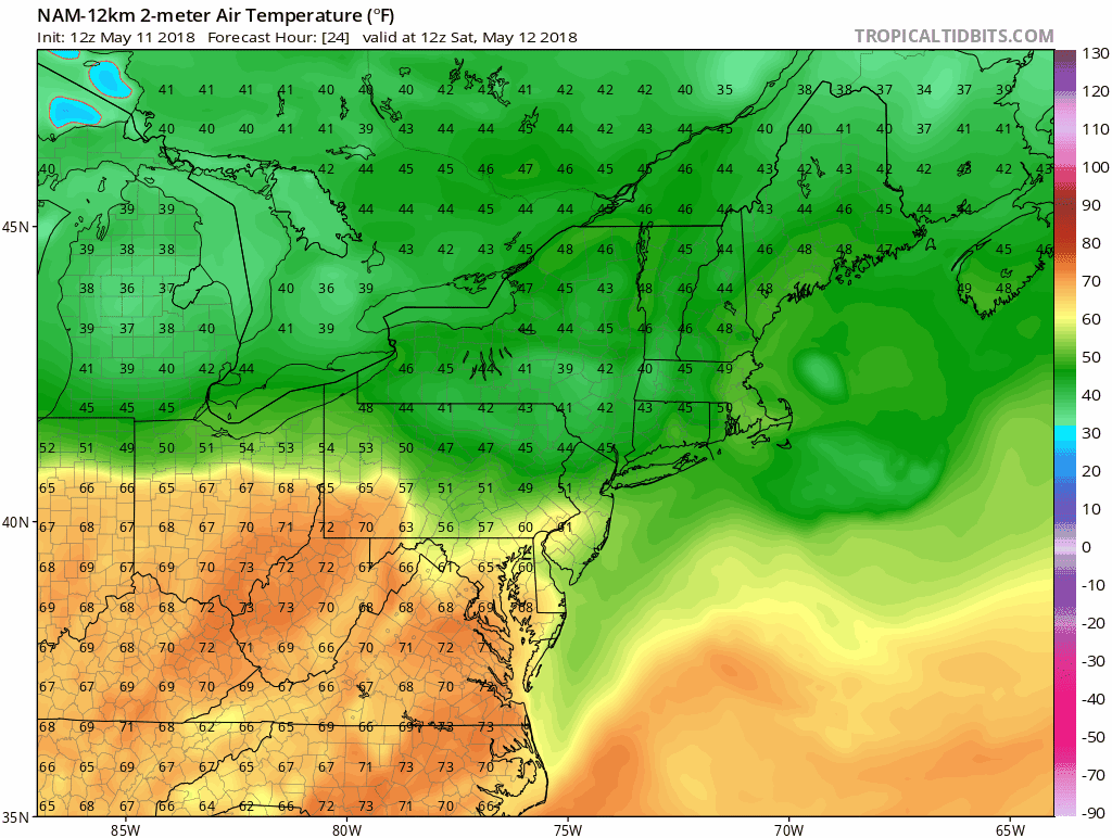
12Z NAM forecast maps of 2-meter temperatures from 24 hours (8AM Saturday) to 60 hours (8PM Sunday) with dramatically cooler air pushing from northeast-to-southwest on Sunday following the passage of a back door cool front; maps courtesy NOAA/EMC, tropicaltidbits.com
Overview
Earlier this year, we experienced a dramatic weekend temperature drop here in the I-95 corridor following the passage of a strong back door cold front that brought temperatures down from the 70’s to the 30’s in just a several hour period. Though perhaps not quite as dramatic, this upcoming weekend could very well feature a big change in temperatures between Saturday afternoon and Sunday following the passage of another back door cool front. In addition, the arrival of this back door cool front could result in severe thunderstorm activity late tomorrow into tomorrow night in the I-95 corridor region from DC-to-Philly-to-NYC.

The 8AM Friday morning US surface map features a west-to-east oriented cool front cutting right across across the Mid-Atlantic region. This system will stall out today in the southern Mid-Atlantic region and then return to the north as a warm front early Saturday. By Saturday night, this same front will turn around one more time and drop southward as a cool front. Map courtesy NOAA/WPC
Meandering frontal system
The cool frontal system that passed through the region late yesterday will stall out just to our south later today and then return by early tomorrow as a northward-moving warm front. The arrival of the warm front late tonight and early tomorrow may result in some shower activity in the DC-to-Philly corridor, perhaps even an isolated thunderstorm around daybreak with the greatest chance of rain north of the PA/MD border. Following the passage of the warm front, much warmer and more humid air will push northward into the DC and Philly metro regions and afternoon temperatures on Saturday are likely to climb into the 80’s around Philly and to near 90 degrees for highs in the DC metro region.
Low pressure will then move eastward along the front in the northern Mid-Atlantic region on Saturday night and this will help to push the frontal system back to the south as a cool front. The passage of this back door cool front late tomorrow night will result in big temperature changes around here between Saturday afternoon (80’s) and Sunday (50’s in Philly, 60’s in DC) as much cooler air moves from northeast-to-southwest. (While DC may reach 90 degrees on Saturday, Boston will struggle to rise much past 50 degrees). The threat for showers will continue here on Sunday to go along with the much cooler conditions and there can be another few thunderstorms.

An impressive wave of energy in the upper atmosphere (circled region) will enhance chances for severe thunderstorms late tomorrow/tomorrow night as much cooler air to the north clashes with very warm, humid air to the south of the frontal boundary zone; map courtesy NOAA/EMC, tropicaltidbits.com
Severe weather threat late tomorrow/tomorrow night
The ingredients are coming together for a potential severe weather outbreak late tomorrow/tomorrow night in the DC-to-Philly-to-NYC corridor as the frontal system begins its turnaround and drops southward as a cool front. In addition, very warm and humid air will be in place in the DC-to-Philly corridor by later tomorrow and this will set up quite a clash with the much cooler and heavier air advancing southward from the northern Mid-Atlantic region. Furthermore, upper-air conditions will be very favorable for strong convection later tomorrow and tomorrow night as upward motion and winds will become quite strong with the approach of a vigorous short-wave of energy and deep-layer wind shear will become quite high. This type of environment could result in thunderstorm cells that can produce damaging wind gusts (bow echoes) and perhaps even large hail. Isolated tornadoes are also possible from northern Maryland to southern Pennsylvania and New Jersey as low-level wind shear increases to the northeast of a surface low pressure system that should form just south of the Mason-Dixon Line.

12Z NAM-Nest forecast map of updraft helicity swath for 8PM Saturday evening suggesting there will be "spin" in the atmosphere across Pennsylvania and NJ contributing to the severe weather threat; map courtesy NOAA/EMC, College of DuPage
Looking ahead to next week's heavy rain potential
This same frontal system may actually impact the region through much of next week as it should remain in relative close proximity to the DC-to-Philly-to-NYC corridor. As a result, unsettled weather conditions are likely for much of next week with multiple chances of additional showers and thunderstorms. Heavy rain totals are quite possible by the end of next week and localized flooding may eventually become a real concern in the Mid-Atlantic region.
Meteorologist Paul Dorian
Vencore, Inc.
vencoreweather.com