
9:50 AM | **Tropical moisture riding northward from the Caribbean Sea and Gulf of Mexico to likely result in significant rainfall around here next five days**
Paul Dorian
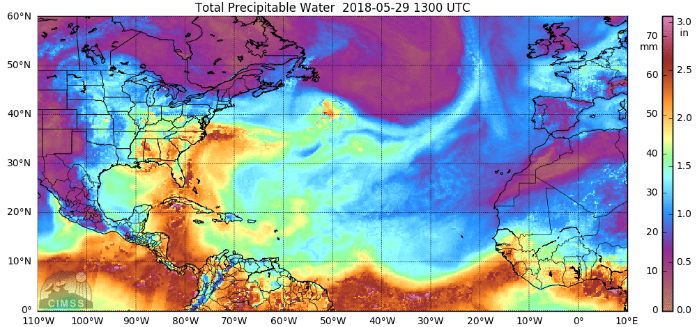
The total precipitable water loop for the past 24 hours shows an influx of tropical moisture into the eastern US from the Caribbean Sea and Gulf of Mexico (indicated by yellows/oranges/reds). This deep layer of moisture will contribute to soaking rainfall around here during the next five days or so; maps courtesy University of Wisconsin/CIMMS
Overview
The grounds are already well saturated in the DC-to-Philly corridor after recent soaking rains and there is more significant rainfall on the way. Tropical moisture is riding northward from the Caribbean Sea and Gulf of Mexico and it is now firmly entrenched in the eastern third of the nation. Disturbances in the upper atmosphere will head our way from the Midwest over the next several days and tap into this abundant moisture and the result is likely to be downpours later this week and during the upcoming weekend.
Details
The combination of high pressure pushing eastward along the Northeast US coastline and low pressure over the Midwest associated with the remains of Tropical Storm Alberto is resulting in an influx of tropical moisture in our area riding northward from the Caribbean Sea and Gulf of Mexico. Meanwhile, an upper-level trough will shift eastward from the Great Lakes over the next few days and this will “squeeze” out the deep moisture in the atmosphere likely resulting in some downpours in DC, Philly and perhaps as far north as NYC. The upper-level trough may actually "close off" for a time this weekend enhancing the possibility of heavy rainfall in parts of the I-95 corridor. The result of a "closed-off" low will likely be the formation of surface low pressure this weekend in the I-95 corridor region and this could lead to downpours in the Saturday-Sunday time frame.

Upper-level disturbances including this one over the Mid-Atlantic region this weekend (indicated by yellow) will combine with entrenched tropical moisture to produce soaking rainfall; map courtesy NOAA, tropicaltidbits.com
Grounds are already well saturated in parts of the Mid-Atlantic region from recent rains and additional downpours over the next five days can lead to flash flooding problems. For the month of May so far, Philly is 1.74 inches above-normal for monthly rainfall and DC has been very wet with an above-normal measurement of 3.68 inches. On the back side of the surface low pressure system, Sunday and Monday are likely to turn cooler with high temperatures possibly confined to 70 degrees or so for daytime highs.
Meteorologist Paul Dorian
Vencore, Inc.
vencoreweather.com
Extended morning video discussion on the soaking rain threat over the next five days or so: