
10:50 AM | **The next week or so should be the worst stretch of heat and humidity this summer in the Northeast US**
Paul Dorian
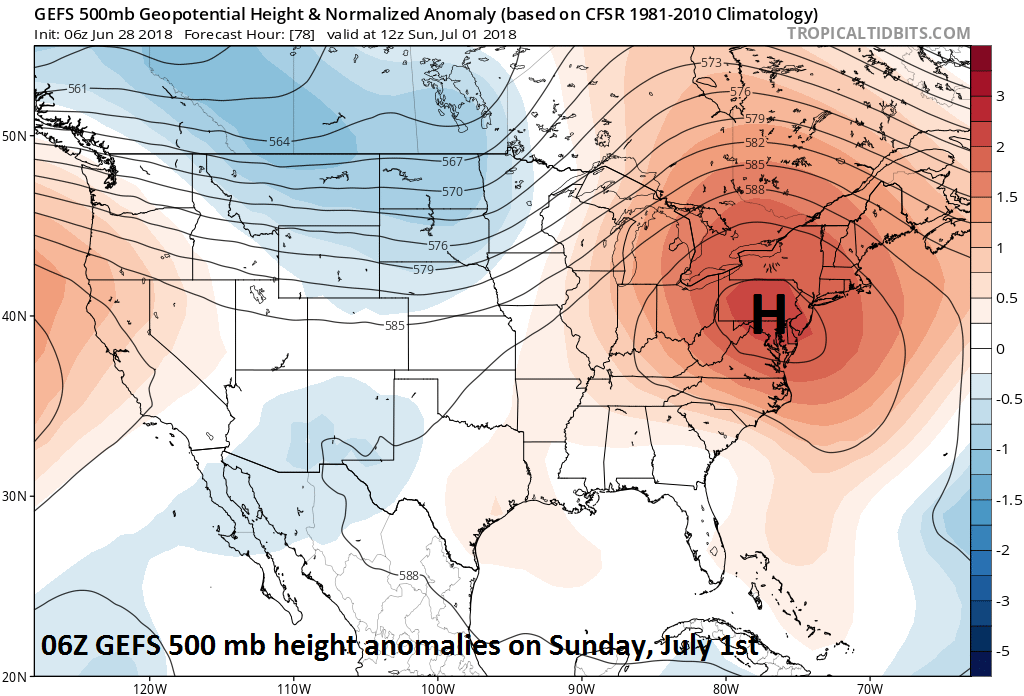
06Z GEFS forecast map of 500 mb height anomalies on Sunday, July 1st with abnormally strong high pressure ridging centered over the Northeast US; courtesy NOAA, tropicaltidbits.com
Overview
Showers and embedded strong thunderstorms in the overnight hours were associated with the passage of a warm frontal system that has resulted in noticeably warmer and more humid air for the Mid-Atlantic region; especially, when compared to the last few comfortable cooler-than-normal days. Today’s temperatures will climb well into the 80’s and the humidity levels have climbed to uncomfortable levels and these harsh conditions will only intensify over coming days. In fact, temperatures should easily reach the 90 degree mark for highs on Friday in the DC-to-Philly-to-NYC corridor and then climb well into the 90's on Saturday, Sunday and Monday - perhaps even a flirtation with the 100 degree mark in some spots on those three days. This stretch of hot and humid weather will likely last for a week or so from its beginning on Friday. The good news is that this extended stretch of heat and humidity could very well be the worst of the summer in the Northeast US as there are signs for more comfortable weather conditions during the second half of July and during the month of August.

06Z GEFS forecast map of 500 mb height anomalies on Friday, July 6th with abnormally strong high pressure ridging centered over the interior western US; courtesy NOAA, tropicaltidbits.com
Details
Upper-level ridging will build into the Northeast US over the next 24 hours or so and then it’ll expand and intensify over the weekend. By the time Sunday rolls around, abnormally high heights at 500 millibars will be centered right over the Mid-Atlantic region and temperatures will respond by climbing well into the 90’s for highs - perhaps even to the 100 degree mark in some spots - and this will go along with very uncomfortable humidity levels. This high heat and humidity will continue into at least the latter part of next week and there will likely be some record highs that fall over this time period. Perhaps even more likely is the possibility that record warm low temperatures will be set in the Mid-Atlantic region as several of the upcoming nights will likely feature only a minimal overnight drop in temperatures. As far as rainfall is concerned, rain-free conditions are likely on Friday, Saturday and Sunday and then there will be a slowly increasing threat for scattered showers and thunderstorms during the first half of next week. The best place for relief during the next several days of high heat and humidity will be at the beaches where a sea breeze is quite likely to form on a daily basis reducing coastal temperatures considerably compared to inland locations.

06Z GEFS forecast map of 850 mb temperature anomalies for days 6-10; courtesy NOAA, tropicaltidbits.com
By the latter part of next week, there will be interesting changes taking place in the overall upper-level pattern of the atmosphere. Specifically, the main axis of the abnormally high heights at 500 mb will "retrograde" (i.e., shift westward) from the Northeast US to a position centered over the interior western US by late next week. The result of this retrogression in the upper-level ridging pattern will be the eventual lessening of the excessive heat in the Northeast US and the likely worsening of the above-normal heat in the interior western US.

06Z GEFS forecast map of 850 mb temperature anomalies for days 11-15; courtesy NOAA, tropicaltidbits.com
As the upper-level ridging shifts westward to the interior western US, the upper-level flow of air over the Northeast US will become northwesterly and this change in direction aloft should allow for a cool frontal passage at the end of next week and more seasonal temperatures. Looking even farther ahead, there are some signs that much of the second half of July and even the month of August might be closer-to-normal in the Mid-Atlantic region with respect to temperatures as an upper-level trough forms near the Great Lakes and Northeast US.

12Z GFS forecast map of 2-meter temperatures on Sunday afternoon, July 1st, with outrageous highs of 100+ degrees in the I-95 corridor; courtesy NOAA/EMC, tropicaltidbits.com
One final note, whenever abnormally strong high pressure ridging sets up in a position over the Northeast US this time of year - as it will do this weekend and into the middle of next week - one has to monitor the tropical region near the Bahamas, Florida and the Gulf of Mexico. With strong high pressure situated to the north, there tends to be low-level convergence in this particular part of the Atlantic Basin tropical region and the flow of air would likely push westward any tropical system that may actually form.
Meteorologist Paul Dorian
Perspecta, Inc.
perspectaweather.com