1:15 PM | *Significant rain for much of the Northeast US/Mid-Atlantic next several days will fall on already well-saturated grounds**
Paul Dorian

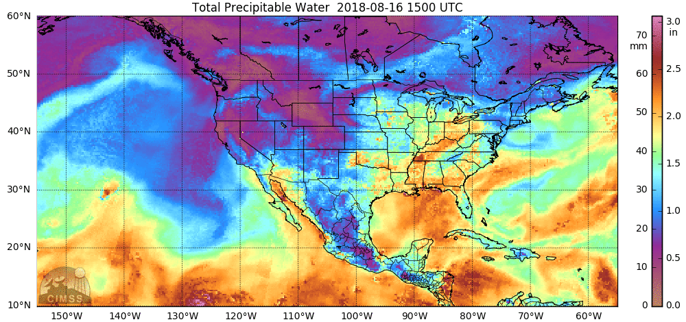
High levels of moisture (shown in orange, yellow) continue to flow northward from the Gulf of Mexico into the Midwest/Mid-Atlantic/Northeast US. This pattern has been quite persistent during the past several weeks and will be persistent over the next several days. Credit NOAA, University off Wisconsin/CIMMS
Overview
It has been a very wet summer in much of the Northeast US/Mid-Atlantic and significant rain is likely to fall in many areas over the next several days. In fact, I think the chances are quite high that some spots see several inches of new rainfall between late today and the middle of next week and this will fall on already well-saturated grounds. A slow-moving cool frontal system will only grudgingly move across the area over the next 48 hours and this will result in numerous rounds of showers and thunderstorms beginning late today and lasting well into the upcoming weekend. This will make it the 10th weekend of the past 13 with some rainfall in at least parts of the Northeast US/Mid-Atlantic. Another front will approach the area late Tuesday and it’ll be supported by a vigorous upper-level energy which is likely to result in more downpours come late Tuesday/early Wednesday.

NOAA's forecast map of 7-day rainfall amounts with significant levels depicted in the eastern US and this is a reasonable prediction, in my opinion, based on the continuing flow of very moist air and vigorous upper-level systems headed into the eastern US.
Late today/tonight
Late this afternoon, a pre-frontal trough will develop to the west of the I-95 corridor and this will led to considerable low-level convergence and the formation of showers and embedded strong thunderstorms. Given the increasing atmospheric instability and high moisture content, any shower or thunderstorm that forms late today/early tonight can produce heavy rainfall in a short period of time. Flash flooding is certainly a concern given the saturated grounds, but perhaps somewhat limited in this particular initial round of rainfall as the storms should move along at a fairly good clip - unlike earlier this week and during the past weekend where they were slow movers.

Shower and thunderstorm threat through the weekend in the Northeast US/Mid-Atlantic aided by strong upper-level energy (circled region). Credit NOAA, tropicaltidbits.com
Weekend
The initial round of showers and thunderstorms is likely to taper off after midnight, but that will not be the end of the rainfall in the Northeast US/Mid-Atlantic. In fact, while neither day this weekend will be a total washout, it'll turn out to be yet another weekend with some rain for this part of the country as a front slowly works its way through the region. On Saturday, low pressure will form along the nearly stationary frontal boundary zone and this is likely to lead to additional rounds of showers and thunderstorms in the Northeast US/Mid-Atlantic and some of the weekend rainfall will be heavy at times. The best chance for heavy rain and strong storms on Saturday will come from mid-afternoon through the nighttime hours.

Shower and thunderstorm threat late Tuesday into Wednesday in the Northeast US/Mid-Atlantic aided by another piece of strong upper-level energy (circled region). Credit NOAA, tropicaltidbits.com
Next week’s rain threat
By Monday, high pressure across New England will be edging its way across the area and the new work week is likely to start off relatively rain-free. However, another vigorous upper-level low will drop southeastward across the Great Lakes on Tuesday and this is likely to result in additional showers and thunderstorms here late Tuesday into Wednesday and – given the expected high moisture content – some of this rainfall can be heavy at times. After that, there are signs for some nice weather later next week (Thursday, Friday) as comfortable high pressure moves in, but there may be quite a bit of soaking rainfall between now and then in an already very soaked part of the country.
Final word...don't be surprised if flash flood watches are put up for much of the Mid-Atlantic and be on the lookout for localized flash flooding between tonight and the middle of next week.
Meteorologist Paul Dorian
Perspecta, Inc.
perspectaweather.com