2:00 PM | ***Weekend accumulating snow for much of the Mid-Atlantic region...looks like a prolonged event for some***
Paul Dorian

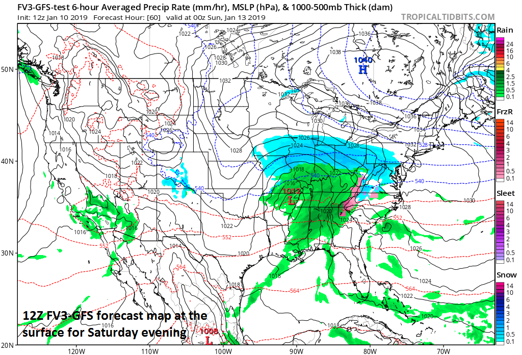
Surface forecast map for Saturday evening with snow (blue) edging eastward into the Mid-Atlantic region (12Z FV3-GFS); courtesy NOAA, tropicaltidbits.com.
Overview
Accumulating snow continues to be a threat for the weekend in the Mid-Atlantic region with signs pointing to heavier amounts during this event in areas to the south of the PA/MD border. Low pressure will pull out of the southern US on Saturday and head towards the Tennessee Valley before ultimately winding up near the Outer Banks of North Carolina by late Sunday. Snow will break out on Saturday in the central Mississippi Valley and then push eastward to the Ohio Valley and then to the Mid-Atlantic region during the PM hours. On Sunday, as low pressure heads towards the North Carolina coastline, snow will continue in the Mid-Atlantic region with the heaviest amounts likely across Virginia, Maryland, Delmarva Peninsula and perhaps southern New Jersey.

Surface forecast map for Sunday afternoon with snow (blue) generally confined to areas south of the PA/MD border (12Z FV3-GFS); courtesy NOAA, tropicaltidbits.com.
Weekend snow
Early Saturday, low pressure will pull out of the southern states and heads northeast towards the Tennessee Valley. At the same time, strong cold Arctic high pressure will slide eastward across southern Canada providing the Mid-Atlantic region with reinforcing cold air for the weekend event. Significant snow will break out across the central Mississippi Valley on Saturday with several inches likely in places like Missouri and Illinois. The upper-level support for this system on Saturday will be rather impressive with a well-defined feature at 500 mb and this will support the heavy snowfall for the Mississippi Valley. As the upper-level system pushes to the east, the upper-level support will tend to get “strung out” and this may tend to reduce the intensity somewhat of the snow that reaches the Mid-Atlantic region later in the day and eventually, it may actually prolong the entire event with snow possibly lingering in parts of the Mid-Atlantic until late Sunday night (e.g., in Virginia). In addition, the low-level of the atmosphere in the Mid-Atlantic region will be quite cold and very dry on Saturday and this may delay the arrival of the snow for awhile – at least that which reaches the ground (i.e., virga) - until the atmosphere gets better saturated. The bottom line, while snow is likely Saturday afternoon and Saturday evening in the Mid-Atlantic region, accumulations may be somewhat limited as compared with, for example, what the central Mississippi Valley sees earlier in the day.

“Well-defined” upper-level wave of energy as of Saturday afternoon (12Z FV3-GFS)
By late Saturday night and Sunday, the snow may actually pick up in intensity in at least parts of the Mid-Atlantic region as surface low pressure intensifies some as it heads towards the North Carolina coastline. It currently appears that the biggest impact on Sunday from the low pressure/southern stream energy will be in areas south of the PA/MD border. In fact, there is a chance that the heaviest snow on Sunday takes place in much the same area that got hit hardest by the December snowstorm (e.g., in the region from Charlottesville, VA to Richmond, VA).

“Strung-out” upper-level energy as of Sunday afternoon (12Z FV3-GFS)
There are still a couple of days to go and a small change in the track and intensity of the important upper-level features can have an important impact for the weekend event. Early snowfall estimates for the Mid-Atlantic range from a coating to 2 inches in New York City, 1-3 inches in the Philly metro area, and 3-6 inches in the DC metro region. The heavier amounts in those accumulation estimates are likely across southern and western sections of the metro regions and the lower amounts in the northern suburbs.
Looking ahead
One final point, the snowstorm in December that hit southern parts of the Mid-Atlantic region and the one in November that hit the DC-to-NYC corridor quite hard turned out to be relatively isolated snow events. This weekend snow event, however, may be just the opening act in what promises to be a long-term colder and snowier weather pattern that’ll get underway in earnest by the third week of January.
Meteorologist Paul Dorian
Perspecta, Inc.
perspectaweather.com
Video discussion: